This item has been sold, but you can get on the Waitlist to be notified if another example becomes available, or purchase a digital scan.
1724 Delisle Map of the Eastern Hemisphere (w/ Sea of Korea)
HemisphereOriental-delisle-1724$550.00

Title
Hemisphere Oriental.
1724 (dated) 19 x 20 in (48.26 x 50.8 cm) 1 : 54000000
1724 (dated) 19 x 20 in (48.26 x 50.8 cm) 1 : 54000000
Description
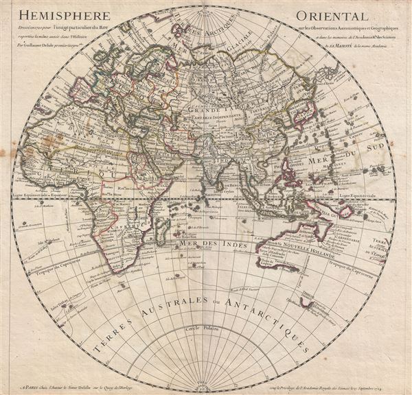
An attractive 1724 map of the Eastern Hemisphere by the well-regarded French cartographer Guillaume Delisle. The map covers the Eastern Hemisphere from Pole to Pole and, along the Equator, from Western Africa to Eastern Australia, including all of Africa, Europe and Asia, as well as what little was known of Australia. Though rife with speculation, Delisle attempts to present a grand overview of the known world based upon the best reconnaissance available in the early 18th century. Northeastern Asia, the interior of Africa, the Arctic, Antarctic, and Antipodes were, for all intent and purposes, unexplored. The routes of well-known explorers, including Halley and Abel Tasman, are noted.
By the early 17th century most of the coasts of Europe, Africa, and South Asia were well known, as reflected in this map. The map comes to life in those lesser known regions, including Australia, the interior of Africa, and the lands to the north and east of Japan. Our overview of this map will therefore begin in Australia, which had just begun to take concrete form following the explorations of Abel Tasman and others. The map clearly illustrates the western coasts of Australia, here identified as Nouvelle Hollande, though it leaves the eastern shores undefined. Delisle suggest a possible connection with New Guinea, through does not go so far as to unite the two landmasses. Van Diemen's Land or Tasmania appears to the southeast of the mainland of New Holland, but at this point in history only its southern shores had been mapped, and those only tenuously. It remained unclear that Tasmania was an island until the late 17th century navigations of Captain James Cook. Far to the east, at the border of the map itself, is another landmass labeled Terre Australe du S'Espirit, with several rivers but no western shore. Terre Australe du S'Espirit, in fact the New Hebrides, was mis-mapped by the near insane and zealously Catholic 17th century Portuguese navigator Pedro Fernandes de Queiros, who proclaimed that he had discovered the long speculated Great Southern Continent, or Terre Australis. Not to be confused with modern day Australia, Terre Australis was a vast theoretical continent that supposedly covered much of the southern hemisphere in Aristotelian symmetry with the bulk of Asia in the Northern Hemisphere.
Another area of exceptional interest and great speculation are the islands to the north of Japan, here identified as 'Terre de Yeco,' 'Terre de la Compagnie,' and 'Terre vue par Dom Jean de Gama.' 'Yeco' or 'Jesso' is a name usually associated with Hokkaido (which here is drawn as part of mainland Asia), this land mass is often mapped either as or together with Gama or Gamaland and Compagnie. Jean de Gama is a mysterious 17th century Spanish explorer who rumors claim discovered islands rich in gold and silver northeast of Japan - a kind of Asian El Dorado. The Dutch navigators Maerten de Vries and Cornelis Jansz Coen were among the first navigators to sail into this unknown region in search of Gama's islands. Both Gama and Compagnie as presented here reflect preliminary sightings of the Japanese Kuril Islands in 1643 by de Vries and Coen. Two other apocryphal islands, set to the east of Japan, also have some bearing on this legend and are named only 'Rica de Oro' and 'Rica de Plana' ('Rich in Gold' and 'Rich in Silver'). Delisle presumably realized that neither Gama nor Compagnie were Juan de Gama's mineral rich islands, but found the legend too compelling to give up altogether. The seas to the north of the Detroit d'Uriez, are identified as Mer D'Amur (often called Mer D'Amor) and represent pure unfounded speculation.
The interior of Africa is also mostly speculative. Zones suggestive of actual cartographic knowledge are limited to North Africa, Egypt and Abyssinia, the western part of the Niger River Valley as far as Timbuktu, the Congo, and Gold Coast, and the region opposite Madagascar identified as Momomotapa. North of Monomotapa, a long lake, identified near the city of Maravi, bears a striking resemblance to Lake Malawi, and suggests some early knowledge of the great Rift Valley lakes, most likely drawn from indigenous accounts. In the Nile Valley itself Delisle has chosen to focus on the Blue Nile, with its known source at Lake Tana in Abyssinia (modern day Ethiopia), as the primary tributary of the Nile, rather than the White Nile, which he allows to taper ojf just south of Gondar. Delisle has fully abandoned the Montes del Luna and other speculations on the source of the Nile - a remarkably sophisticated decision that few other cartographers were bold enough to embrace.
The sea between Japan and Korea, whose name, either the 'Sea of Korea,' 'East Sea,' or the 'Sea of Japan,' is here identified in favor of Korea (Mer de Coree). Historically, Korea has used the term 'East Sea' since 59 B.C., and many books published before the Japanese annexed Korea make references to the 'East Sea' or 'Sea of Korea.' Over time, neighboring and western countries have identified Korea's East Sea using various different terms. The St. Petersburg Academy of Sciences referred to the East Sea as 'Koreiskoe Mope' or 'Sea of Korea' in their 1745 map of Asia. Other seventeenth and 18th century Russian maps alternate between 'Sea of Korea' and 'Eastern Ocean.' The 18th century Russian and French explorers Adam Johan von Krusenstern and La Perouse called it the 'Sea of Japan,' a term that became popular worldwide. Nonetheless, the last official map published by the Russians name the East Sea the 'Sea of Korea.' The name is currently still a matter of historical and political dispute between the countries.
This map was published by Guillaume Delisle form his offices at Quay de l'Horloge, Paris. The first edition was drawn in 1720. The present example represents and updated and revised edition presented to and approved by the Acadamie Royale des Sciences on the 15th of September, 1724. It proved popular with this and subsequent editions being published and revised throughout the 17th century.
Cartographer
The De L'Isle family (fl. c. 1700 - c. 1760) (also written Delisle) were, in composite, a mapmaking tour de force who redefined early 18th century European cartography. Claude De L'Isle (1644 -1720), the family patriarch, was Paris based a historian and geographer under Nicholas Sanson. De L'Isle and his sons were proponents of the school of "positive geography" and were definitive figures, defining the heights of the Golden Age of French Cartography. Of his twelve sons, four, Guillaume (1675 - 1726), Simon Claude (1675 - 1726), Joseph Nicholas (1688 - 1768) and Louis (1720 - 1745), made a significant contributions to cartography. Without a doubt Guillaume was the most remarkable member of the family. It is said that Guillaume's skill as a cartographer was so prodigious that he drew his first map at just nine years of age. He was tutored by J. D. Cassini in astronomy, science, mathematics and cartography. By applying these diverse disciplines to the vast stores of information provided by 18th century navigators, Guillaume created the technique that came to be known as "scientific cartography", essentially an extension of Sanson's "positive geography". This revolutionary approach transformed the field of cartography and created a more accurate picture of the world. Among Guillaume's many firsts are the first naming of Texas, the first correct map of the Mississippi, the final rejection of the insular California fallacy, and the first identification of the correct longitudes of America. Stylistically De L'Isle also initiated important changes to the medium, eschewing the flamboyant Dutch style of the previous century in favor of a highly detailed yet still decorative approach that yielded map both beautiful and informative. Guillaume was elected to the French Academie Royale des Sciences at 27. Later, in 1718, he was also appointed "Premier Geographe du Roi", an office created especially for him. De L'Isle personally financed the publication of most of his maps, hoping to make heavy royalties on their sales. Unfortunately he met an untimely death in 1728, leaving considerable debt and an impoverished child and widow. De L'Isle's publishing firm was taken over by his assistant, Phillipe Buache who became, posthumously, his son in law. The other De L'Isle brothers, Joseph Nicholas and Louis De L'Isle, were employed in the Service of Peter the Great of Russia as astronomers and surveyors. They are responsible for cataloguing and compiling the data obtained from Russian expeditions in the Pacific and along the northwest coast of America, including the seminal explorations of Vitus Bering and Aleksei Chirikov. The De L'Isles, like their rivals the Vaugondys , must be considered speculative geographers. Speculative geography was a genre of mapmaking that evolved in Europe, particularly Paris, in the middle to late 18th century. Cartographers in this genre would fill in unknown areas on their maps with speculations based upon their vast knowledge of cartography, personal geographical theories, and often dubious primary source material gathered by explorers and navigators. This approach, which attempted to use the known to validate the unknown, naturally engendered many rivalries. The era of speculatively cartography effectively ended with the late 18th century explorations of Captain Cook, Jean Francois de Galaup de La Perouse, and George Vancouver. More by this mapmaker...
Condition
Good. Original centerfold exhibits some wear. Lower and upper margins narrow, but intact. Platemark visible. Some discolorations left center extending into the margins.
References
Rumsey 4764.003. East Asian Map Collection, Sea of Korea Collection, EAMC 163.