This item has been sold, but you can get on the Waitlist to be notified if another example becomes available, or purchase a digital scan.
1879 Gray Map of the World in Two Hempispheres
Hemispheres-gray-1879$100.00

Title
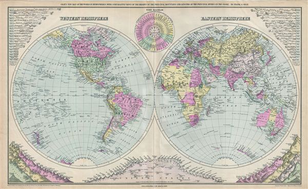
Gray's New Map of the World in Hemispheres, with Comparative Views of the Heights of the Principal Mountains and Lengths of the Principal Rivers on the Globe.
1879 (dated) 17 x 27 in (43.18 x 68.58 cm)
1879 (dated) 17 x 27 in (43.18 x 68.58 cm)
Description
This is a beautiful example of Frank A. Gray's 1879 map of the world on a hemispherical projection. This map is significant as, in addition to a world map, it must be considered the first modern comparative mountains and rivers chart. Gray combines Mitchell Jr.'s hemispheres into a single global double hemispheric projection and incorporates correctly scaled comparative data in each of the map's corners. The advantages of this system are obvious, for not only does Grey offer comparative data isolated hemispherically, he also places each in such that it can also be compared globally. Possibly pandering to his audience, Gray also incorporates a center weighted chart that details the peaks of the United States. Subsequent comparative mappings of the world's mountains and rivers generally follow the Gray model.
An interesting time diagram near the top center margin indicating the local time in the fifty principal cities of the world, while noon in Washington. The Antarctic continent is shown only sketchily, representing the relatively primitive state of Antarctic exploration in 1879. This map was drawn by Frank A. Gray and engraved by William H. Holmes. Dated, copyrighted, and entered according to Act of Congress, in the year 1879, by O. W. Gray & Sons, in the office of the Librarian of Congress at Washington.
An interesting time diagram near the top center margin indicating the local time in the fifty principal cities of the world, while noon in Washington. The Antarctic continent is shown only sketchily, representing the relatively primitive state of Antarctic exploration in 1879. This map was drawn by Frank A. Gray and engraved by William H. Holmes. Dated, copyrighted, and entered according to Act of Congress, in the year 1879, by O. W. Gray & Sons, in the office of the Librarian of Congress at Washington.
Cartographer
Ormando Wyllis Gray (March 3, 1829 – July 6, 1912) was a mid to late 19th century map publisher with offices in New York City, Philadelphia, PA, and Danielsonville, Connecticut. Born in Townshend, Vermont, he attended Norwich College where he studied civil engineering and became a civil engineer and surveyor. Gray's first commercial atlas was an 1869 survey of Windhamd and Toland counties, Connecticut. His most important work seems to have been done in conjunction with other, more prominent map publishers, including Henry Walling and G.W. and C.B. Colton. Gray is best known for his state and county atlases, though did, with his sons, also independently issue at least two national atlases in the late 1870s. He retired from the map publishing business in 1890. He died at home in Bernardston, Massachusetts. He married Roxcena L. Arnold in 1851, with whom he had three daughters and one son. More by this mapmaker...
Source
Gray, F., Atlas of the State of Maine, (Philadelphia: O.W. Gray and Sons) 1879.
Condition
Very good. Original centerfold visible. Minor wear along top and bottom edges.
References
Rumsey 1537.050 (1885 edition).