This item has been sold, but you can get on the Waitlist to be notified if another example becomes available, or purchase a digital scan.
1839 Mitchell Map of the World in Hemispheres (Northern, Southern, Eastern and Western)
Hemispheres-mitchell-1839$37.50

Title
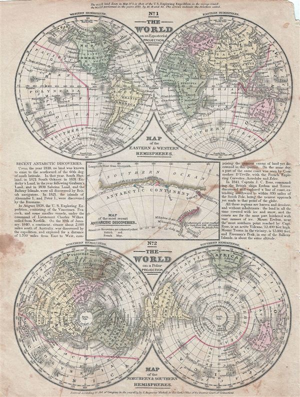
No. 1 The World on an Equatorial Projection. No. 2 The World on a Polar Projection. No. 3 Map of the most recent Antarctic Discoveries.
1839 (dated) 12 x 9.5 in (30.48 x 24.13 cm)
1839 (dated) 12 x 9.5 in (30.48 x 24.13 cm)
Description
This is an example of Mitchell's 1839 map of the World in hemispheres. Divided into three separate maps, the first map details the world on an equatorial projection, covering the Western and eastern Hemispheres. The route of the 'U.S. exploring expedition' in the years 1838 – 1842 is noted. The second map features the world on a polar projection featuring the Southern and the Northern Hemispheres. Maps are coded according to continents, countries are named but boundaries are not shown. Various important cities, rivers, deserts, and several other topographical details are noted. The third map details the Antarctic continent according to the latest discoveries of the time. Notes the southernmost point reached by Ross in 1841 (830 miles from the South Pole). This map is color coded according to discoveries made by the America, British and French explorers. Text on each side of the map notes the progress of discoveries made on the Antarctic continent from 1819 to 1841. Map is dated and copyrighted 'entered according to Act of Congress in the year 1852 by S. Augustus Mitchell in the Clerk's Office of the District Court of the eastern district of Pennsylvania.'
Cartographer
Samuel Augustus Mitchell (March 20, 1792 - December 20, 1868) began his map publishing career in the early 1830s. Mitchell was born in Bristol, Connecticut. He relocated to Philadelphia in 1821. Having worked as a school teacher and a geographical writer, Mitchell was frustrated with the low quality and inaccuracy of school texts of the period. His first maps were an attempt to rectify this problem. In the next 20 years Mitchell would become the most prominent American map publisher of the mid-19th century. Mitchell worked with prominent engravers J. H. Young, H. S. Tanner, and H. N. Burroughs before attaining the full copyright on his maps in 1847. In 1849 Mitchell either partnered with or sold his plates to Thomas, Cowperthwait and Company who continued to publish the Mitchell's Universal Atlas. By about 1856 most of the Mitchell plates and copyrights were acquired by Charles Desilver who continued to publish the maps, many with modified borders and color schemes, until Mitchell's son, Samuel Augustus Mitchell Junior, entered the picture. In 1859, S.A. Mitchell Jr. purchased most of the plates back from Desilver and introduced his own floral motif border. From 1860 on, he published his own editions of the New General Atlas. The younger Mitchell became as prominent as his father, publishing maps and atlases until 1887, when most of the copyrights were again sold and the Mitchell firm closed its doors for the final time. More by this mapmaker...
Condition
Good. Some spotting at various places. Overall toning. Narrow top and bottom margins. Blank on verso with erased pencil marks.