This item has been sold, but you can get on the Waitlist to be notified if another example becomes available, or purchase a digital scan.
1951 Humorous Pictorial Postcard Map of Texas
HereLiesTexas-randolph-1951$100.00

Title
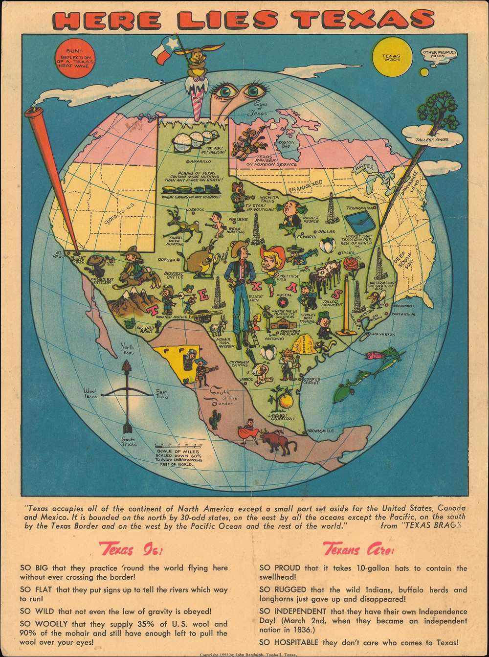
Here Lies Texas.
1951 (dated) 10.5 x 7.75 in (26.67 x 19.685 cm)
1951 (dated) 10.5 x 7.75 in (26.67 x 19.685 cm)
Description
This is a 1951 John Randolph oversize pictorial postcard map of Texas. The map depicts North America dominated by a grossly outsized Texas dominating the continent from the Pacific Ocean to the Great Lakes and from the Arctic Ocean to the Yucatan. The western United States was 'ceded to [the] U.S.', while the northern plains are labeled as 'unannexed'. The northeast is 'Dam Yankee Land' and the south is simply 'Deep South Suh!'. Canada is unlabeled, with a 'Texas Ranger on Foreign Service', while Mexico and Central America are referred to by the phrase 'South of the Border'. Numerous cities are labeled throughout the state, including Austin, Dallas, Fort Worth, El Paso, San Antonio, Houston, and Corpus Christi. A compass in the lower left corner, in the form of a bow and arrow, points the way to 'North Texas', 'East Texas', 'South Texas', and 'West Texas'.
Pictorial vignettes are used to illustrate the superlatives used to describe the state. Some, like the 'wheat grains on [the] way to market' or the view of the Alamo are fairly straight forward. Others provide a much more comic element, such as the 'beefiest cattle' with a very round cow standing on a scale, or the 'finest deer hunting' which features a buck standing on its hind legs carrying a rifle. Another such vignette is the one illustrating the 'orneriest rattlers', embodied by a rattlesnake with two arms shaking a baby rattle. 'Swiftest justice' is portrayed by a cowpoke blasting the head off another man with only a bullet. Randolph also makes it clear that 'everything is bigger in Texas' by including the 'tallest smoke stack', the 'tallest pines', and the 'tallest men', which are second only to the 'prettiest girls'. A Texas Moon, situated in the upper right, also dwarfs 'other people's moon'. Randolph also apparently foresaw our current political environment, since, in the northern part of Texas he includes an illustration of a man playing a guitar with the caption, 'TV Star? No, Politician'.
Pictorial vignettes are used to illustrate the superlatives used to describe the state. Some, like the 'wheat grains on [the] way to market' or the view of the Alamo are fairly straight forward. Others provide a much more comic element, such as the 'beefiest cattle' with a very round cow standing on a scale, or the 'finest deer hunting' which features a buck standing on its hind legs carrying a rifle. Another such vignette is the one illustrating the 'orneriest rattlers', embodied by a rattlesnake with two arms shaking a baby rattle. 'Swiftest justice' is portrayed by a cowpoke blasting the head off another man with only a bullet. Randolph also makes it clear that 'everything is bigger in Texas' by including the 'tallest smoke stack', the 'tallest pines', and the 'tallest men', which are second only to the 'prettiest girls'. A Texas Moon, situated in the upper right, also dwarfs 'other people's moon'. Randolph also apparently foresaw our current political environment, since, in the northern part of Texas he includes an illustration of a man playing a guitar with the caption, 'TV Star? No, Politician'.
Publication History and Census
This map was created by John Randolph and published in 1951. This map is fairly rare, with only three known examples in institutional collections and only one other instance when it has been on the private market in recent years.Cartographer
John Hayward Randolph (1908 - 1972) was an American artist and author best known for the 'Texas Brags' series of books, published between 1944 and 1972. Before World War II, Randolph was in advertising. He joined the 124th Cavalry , a unit of the Texas National Guard, in 1942. The unit was soon federalized and became the last unit in the United States Army to be mounted on horses and mules. Originally posted at Fort D. A. Russell during the winter if 1943-44 near Marfa, Texas, Rudolph was bored out of his mind guarding the Mexican border, according to his wife. While in Marfa, Randolph began thinking about an advertising campaign he had worked on before the war for Jax beer that was called 'Texas Brags and Drinks Jax Beer'. He soon wrote his wife and asked her to send him his files from that campaign and began working on the manuscript for the first edition of Texas Brags while not on duty for four months. He sent the finished manuscript to his wife just before his unit was transferred to Fort Riley, Kansas in preparation for deployment to India to clear the Japanese from the Burma Road. Before leaving, Randolph arranged for his friend Mark Storm to illustrate the manuscript and for the finished product to be published by the Anson Jones Press. Once he got back to the United States in 1945, 160,000 copies had sold. More by this mapmaker...
Condition
Very good. Postcard. Even overall toning. Wear along original centerfold. Text and writing on verso.
References
Cornell University, Persuasive Maps: PJ Mode Collection, 1340.01. Rumsey 8209.002. OCLC 46325337.