1947 Japan Travel Bureau Bird's-Eye View of Hiroshima
Hiroshima-travelbureau-1947$1,200.00


Title
Map of Hiroshima.
1947 (dated) 20.5 x 29.5 in (52.07 x 74.93 cm)
1947 (dated) 20.5 x 29.5 in (52.07 x 74.93 cm)
Description
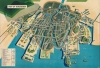
A poignant and surreal bird's-eye view of Hiroshima, Japan published by the Japan Travel Bureau in 1947. Outwardly a conventional tourist map, it also obliquely references the horrific atomic destruction that occurred there just two years prior.
The domed building near center was originally the Hiroshima Prefectural Industrial Promotion Hall. As it was built of stone and steel, it remained largely intact despite being located near the bomb's epicenter. As the city recovered from the war, the building became a symbol of remembrance and was preserved as the Hiroshima Peace Memorial, unofficially known as the Genbaku ('A-Bomb') Dome. In 1996, the Hiroshima Peace Memorial was designated a UNESCO World Heritage Site. In 2016, Barack Obama became the first sitting U.S. President to visit the memorial.
It is notable that this map is primarily in English and that it was produced by the Travel Bureau. Japan was not considered a desirable or easy place to travel to in 1947, suggesting that this was meant for (primarily American) foreign officials and military personnel.
It is worth noting that while the American public was quickly notified about the bombings and given some sense of their scale, military censors and newspaper editors worked to restrict photographs taken on the ground and limit knowledge about the effects on civilians. Once Japan had surrendered, American occupation authorities also controlled the spread of information about the Hiroshima and Nagasaki bombings within Japan.
A Closer Look
A bird's-eye view of the city is presented, oriented to the north-northwest. Though not explicitly stated, the irregular darkened ring at the city's center reflects the area of destruction caused by the atomic blast. Numbers throughout the city correspond to a bilingual index at bottom-left.The domed building near center was originally the Hiroshima Prefectural Industrial Promotion Hall. As it was built of stone and steel, it remained largely intact despite being located near the bomb's epicenter. As the city recovered from the war, the building became a symbol of remembrance and was preserved as the Hiroshima Peace Memorial, unofficially known as the Genbaku ('A-Bomb') Dome. In 1996, the Hiroshima Peace Memorial was designated a UNESCO World Heritage Site. In 2016, Barack Obama became the first sitting U.S. President to visit the memorial.
It is notable that this map is primarily in English and that it was produced by the Travel Bureau. Japan was not considered a desirable or easy place to travel to in 1947, suggesting that this was meant for (primarily American) foreign officials and military personnel.
The First City to Suffer an Atomic Bombing
On the morning of August 6, 1945, the Enola Gay, a B-29 bomber, flew over the city of Hiroshima and dropped the first atomic bomb ever used in warfare. 70,000 - 80,000 people were killed, either instantly by the explosion or in the resulting fire that engulfed the city, and a similar number were injured. Many thousands more died in the following months and years from burns, radiation sickness, and cancer. Nearly five square miles of the city were levelled, with just a handful of structures left standing.It is worth noting that while the American public was quickly notified about the bombings and given some sense of their scale, military censors and newspaper editors worked to restrict photographs taken on the ground and limit knowledge about the effects on civilians. Once Japan had surrendered, American occupation authorities also controlled the spread of information about the Hiroshima and Nagasaki bombings within Japan.
Publication History and Census
The Japanese text on the cover indicates that the map was printed on August 10, 1947 and distributed on August 15, strongly suggesting that it was meant to coincide with the second anniversary of the Japanese surrender. The publisher is listed as Okazaki Seiki (岡崎清記) of the Hiroshima Branch of the Japan Travel Bureau (日本交通公社廣島支社), with Matsui Tomiichi (松井富一) of the Hiroshima Printing Co. (廣島印刷株式會社) as printer. The meaning of the logo 'Nakao' at bottom-right is unclear. This map is not listed in the OCLC, and is only noted among the holdings of the British Museum, the Texas Medical Center Library, and the David Rumsey Historical Map Collection.Condition
Very good. Light wear along centerfold.
References
Rumsey 11265.002. Texas Medical Center Library Reference Code gi203709449. The British Museum Registration Number 2006,0320,0.1.