This item has been sold, but you can get on the Waitlist to be notified if another example becomes available, or purchase a digital scan.
1695 Van Keulen 'Pirate' Map of the Hispaniola and Eastern Cuba
HispaniolaCuba-vankeulen-1695$875.00

Title
Pas kaart Van de Noord Kust van Espaniola met d Eylanden daar Benoorden.
1695 (undated) 20.5 x 23.25 in (52.07 x 59.055 cm) 1 : 1778000
1695 (undated) 20.5 x 23.25 in (52.07 x 59.055 cm) 1 : 1778000
Description
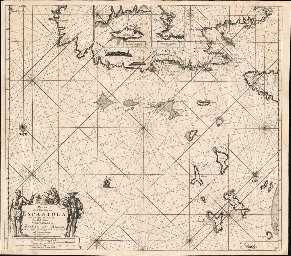
A beautifully engraved 1684 nautical chart or maritime map of the north coast of Hispaniola, the east end of Cuba, the Turks and Caicos islands, and the southeastern reaches of the Bahamas. This southern-oriented chart depicts the heart of the raiding territory of the 'Brethren of the Coast', the buccaneers.
Bad news for the navigator - a monkey appears to be about to make off with his cross-staff.
The Buccaneers
Sometimes, but by no means always with the license of the French, English, or Dutch, the buccaneers used their foothold in Hispaniola to prey on the Spanish at sea and on land throughout the Bahamas, and in Cuba. The Spanish drove most buccaneers were driven off Hispaniola by the 1630s, but they quickly reestablished themselves on the island of Tortuga just off the coast. (The island is here depicted at larger scale in an inset at the top of the map, as is the neighboring harbor of Guanives.) Thus, the heartland of Caribbean piracy is highlighted on this map, printed during what was still their golden age.The Carrrtouche
The chart is one of the very few to actually depict pirates (setting aside those bearing the image of Sir Francis Drake.) The bandanna-wearing sailor, looking sidelong at the viewer whilst displaying navigator's instruments and a plumb line, could arguably be a crewman on any vessel of his day; the dandyish, mustachioed swordsman standing opposite him can be nothing but a buccaneer captain.Bad news for the navigator - a monkey appears to be about to make off with his cross-staff.
The Taíno Discover Columbus
Also marked on this chart is the island of Guanahami, or San Salvador. This is reputed to be the first land in the New World sighted and visited during Christopher Columbus' first voyage, on October 12, 1492. It is worthy of note that the chart preserves the native Taíno name Guanahani as well as Columbus' appellation, San Salvador.Golden Age of Caribbean Piracy (c. 1650 - 1730)
This map appeared at the height of the Golden Age of Caribbean Piracy (c. 1650 - 1730) when the Greater Antilles, Florida, and the Bahamas provided the most fertile hunting ground. Dutch pirates operating with the support of the Dutch West India Company dominated the 17th century until the rise of English piracy in the 1690s. Ultimately, the English (and many other) pirates began establishing themselves in the Bahamas, which were ideally situated to raid Spanish treasure galleons on en route from Havana to St. Augustine, their last stop in the New World before veering to open water for Europe. By early 1700s, Nassau had been declared a 'Pirate Republic' and more than 1,000 pirates had established themselves in the region.Publication History and Census
Although Van Keulen's charts can generally be assigned dates based on typographical changes, this chart does not exhibit those and we have not observed state changes. This chart was introduced to the Van Keulen atlases in 1687, based on the presence of a single page number in the lower right corner in every example we have examined. We suspect this to be a c. 1695 issue of the map, despite there being only one page number rather than two, as appear in most later issues of Keulen charts. The location of the cartouche may have dissuaded the artist from adding the left-hand number block. OCLC only reveals six examples in institutional collections. Several examples of the chart have appeared at auction and in dealer's catalogues over the past ten years.CartographerS
Johannes Van Keulen (1654 – 1715) was a Dutch cartographer active in Amsterdam during the late 17th century. Van Keulen was the son of Lucas van Keulen. Van Keulen's firm, ‘In de Gekroonde Lootsman' (In the Crowned Pilot), was founded in 1678 and registered with the Amsterdam bookseller's guild as 'Cross staff-maker and bookseller.' (The cross-staff is a nautical instrument used to determine latitude.) Two years later, in 1680, they obtained a patent from the States General of Holland and West Friesland to publish nautical charts and atlases. Together with his partner, the cartographer Claes Janz Vooght, Van Keulen published numerous atlases and nautical charts, including the Zee Atlas and Nieuwe Lichtende Zee-Fakkel. It was a massive five-volume atlas containing more than 130 nautical charts. The Zee-Fakkel established the Van Keulen firm as the pre-eminent maker of Dutch sea charts in the late 17th and early 18th century. In 1714, one year before Johannes Van Keulen's death, his son, Gerard van Keulen (1678 - 1726), took charge. Gerard continued to update and republish the Zee-Fakkel until his own death in 1726. The firm was later passed on to Gerard's son, Johannes II Van Keulen (1704 - 1755), who significantly updated the atlas, especially with regard to Asia, issuing the 1753 4th Volume, known as the 'Secret Atlas'. The final editions of the atlas were published by Gerard Hulst van Keulen (1733 - 1801), Joannes II's son. The final true Van Keulen edition of the Zee-Fakkel was published posthumously in 1803. It is noteworthy that though ostensibly controlled by the Van Keulen men, it was the Van Keulen widows who maintained and managed the firm in the periods following their husbands' deaths. After the death of Gerard Hulst Van Keulen's son, Johannes Hulst Van Keulen, ownership of the family plates and business fell into the hands of the Swart family, who continued to publish until the company closed its doors 1885, ending a cartographic legacy spanning nearly 207 years. More by this mapmaker...
Claes Jansz Vooght (1638 – 1696) was a Dutch astronomer, mathematician, teacher, surveyor and cartographer active in Amsterdam during the 17th century. Vooght described himself as a 'surveyor and teacher of mathematics and the art of navigation' and published extensively on these subjects. His is known to have been a surveyor for the Council of Holland and co-authored several books with Rembrantsz Dirck van Nierop. Though little is known of Vooght's life, his most important cartographic work appeared in conjunction with the prominent Johannes Van Keulen firm, with whom he partnered in 1680. Vooght was responsible for creating and compiling most of the maps in Van Keulen's seminal Nieuwe Lichtende Zee-Fakkel, with many early editions bearing only his name. Learn More...
Source
Keulen, J. van, De Nieuwe Groote Lichtende Zee-Fakkel, Part IV (Amsterdam) c. 1695. Also in: Keulen, J. van, Zee-Atlas (Amsterdam) c. 1695.
Condition
Very good condition. Some marginal mends. Two wormholes in water areas not affecting printed image.
References
OCLC 1139000804.