This item has been sold, but you can get on the Waitlist to be notified if another example becomes available, or purchase a digital scan.
1875 Sheafer Map of Pennsylvania
HistoricalPenn-sheafer-1875$225.00

Title
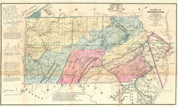
An Historical Map of Pennsylvania showing the Indian Names of Streams and Villages, and Paths of Travel; the Sites of Old Forts and Battle Fields; the Successive Purchases from the Indians; and the Names and Dates of Counties and County Towns, with Tables of Forts and Proprietary Manors.
1875 (dated) 22.5 x 39 in (57.15 x 99.06 cm) 1 : 644000
1875 (dated) 22.5 x 39 in (57.15 x 99.06 cm) 1 : 644000
Description
This is an 1875 P. W. Sheafer map of Pennsylvania. The map depicts the state of Pennsylvania from the border with Ohio to New Jersey, Long Island, and the Atlantic Ocean and from the border with New York to Maryland and West Virginia. Historically significant, a highly detailed history of the state of Pennsylvania is provided here. Captions note locations of battles, as well as changes in the borders between the different colonies / states. The different colored regions within Pennsylvania denote the different acquisitions of territory throughout the state's history. Pennsylvania's evolution is clearly visible.
The map was published by the Historical Society of Pennsylvania, which was founded in 1824. It is accompanied by its original binder, which also contains a 28 page booklet that was published along with the map, which is included.
The map was published by the Historical Society of Pennsylvania, which was founded in 1824. It is accompanied by its original binder, which also contains a 28 page booklet that was published along with the map, which is included.
Cartographer
Peter Wenrick Sheafer (March 31, 1819 - March 26, 1891) created several celebrated maps of Pennsylvania. He was a civil and mining engineer from Pottsville, Pennsylvania. Sheafer was born in Dauphin County, PA and studied engineering in New York. In 1838 he assisted in making the first geological survey of Pennsylvania, trading the line of what was known as 'Second Mountain, the basin of the southern Anthracite coal fields. He settled in Pottsville, PA, center of the mining industry, in 1848. With state support, he continued his survey work in 1849 - publishing, with Robert P. Smith, an important large-scale map of the Anthracite Fields. His mapmaking career included a 1855 Map of Schuykill County, Pennsylvania. He also published the first version of his Official Coal, Iron, Railroad and Canal Map of Pennsylvania and C. in 1863, which was so popular that it was included in the state document Reports of the Several Railroad Companies of Pennsylvania Communicated by the Auditor General of the Legislature. Versions of this map were published until around 1870 in the Auditor General’s reports. Sheafer’s Historical Map of Pennsylvania was published in 1873 and subsequently republished by The Historical Society of Pennsylvania in 1875 with a 28 page booklet of information. Sheafer died at a heath spa in Brown's Mills, New Jersey, not far from Atlantic City. More by this mapmaker...
Condition
Good. Backed on archival tissue for stability. Blank on verso. Comes with original binding Historical Map of Pennsylvania, 1875 which includes a 28 page booklet about the map.
References
OCLC 423610840.