This item has been sold, but you can get on the Waitlist to be notified if another example becomes available, or purchase a digital scan.
1740 Senex / Overton Map of the Netherlands
Holland-overton-1740$375.00

Title
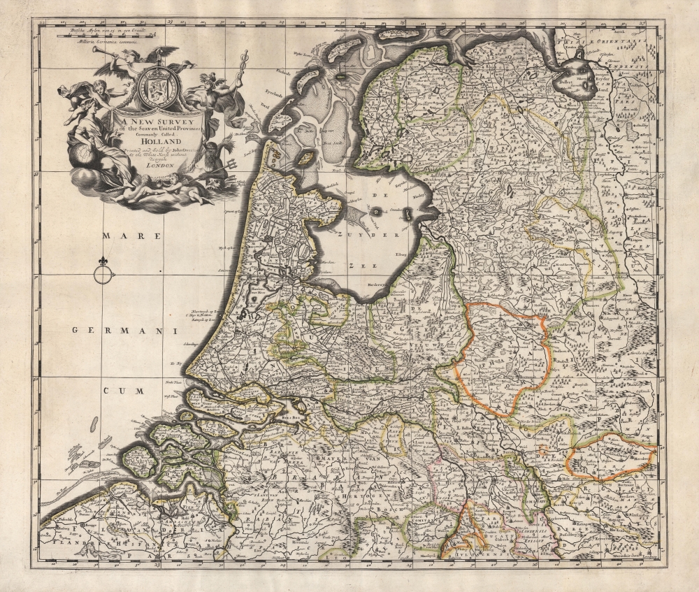
A New Survey of the Seaven United Provinces Commonly Called Holland.
1740 (undated) 18.5 x 20.25 in (46.99 x 51.435 cm) 1 : 600000
1740 (undated) 18.5 x 20.25 in (46.99 x 51.435 cm) 1 : 600000
Description
An unrecorded c. 1740 John Overton map of the Netherlands, based on the 1721 map of the same by John Senex, published in the latter's A New General Atlas of the World. Adopting the convention of the time, 'Holland' is used synonymously with the entire United Provinces.
Though this map postdates the Dutch Golden Age, wealthy Dutch cities, especially Amsterdam (near center) continued to carry significant economic and cultural heft. Rotterdam (at center towards bottom-left), Antwerp (at bottom towards left), Bruges (at bottom-left), Utrecht (near center), and other cities are clearly indicated. The Hague, which had acquired an important political role as the seat of government for both Hollands and the United Provinces writ large, appears here as 's-Gravenhage.'
From Senex's map, Overton has changed the title cartouche and made some slight alterations, such as the display of placenames on the island of Ysselmonde (IJsselmonde) near Rotterdam. Two scales were also added above the title, while the text 'Longitude from London' was removed. Overton's printing of the map does not appear in any institutional collections and has no known history on the market, while Senex's map is also quite scarce, only being independently cataloged among the holdings of four institutions in the OCLC (19708180).
A Closer Look
The entire Dutch Republic as well as portions of surrounding territories such as Flanders are covered in minute detail. Roads, rivers, mountains, forests, sandbars, fortifications, and other features are noted throughout.Though this map postdates the Dutch Golden Age, wealthy Dutch cities, especially Amsterdam (near center) continued to carry significant economic and cultural heft. Rotterdam (at center towards bottom-left), Antwerp (at bottom towards left), Bruges (at bottom-left), Utrecht (near center), and other cities are clearly indicated. The Hague, which had acquired an important political role as the seat of government for both Hollands and the United Provinces writ large, appears here as 's-Gravenhage.'
Publication History and Census
This map was published around the year 1740 by the firm John Overton, then managed by the founder and namesake's sons. It is based on John Senex's 1721 map 'The Dutch Netherlands or the Seven United Provinces commonly called Holland,' which appeared in his A New General Atlas of the World, itself strongly influenced by Jansonnius-Hondius' 'Belgii Foederati Nova Descriptio,' originally published around 1660.From Senex's map, Overton has changed the title cartouche and made some slight alterations, such as the display of placenames on the island of Ysselmonde (IJsselmonde) near Rotterdam. Two scales were also added above the title, while the text 'Longitude from London' was removed. Overton's printing of the map does not appear in any institutional collections and has no known history on the market, while Senex's map is also quite scarce, only being independently cataloged among the holdings of four institutions in the OCLC (19708180).
CartographerS
John Overton (1640 - 1708) was an English cartographer and map publisher active in the late 16th and early 17th century. He shop, a noted on many of his maps, was at the sign of the Whitehorse without Newgate. While little of Overton's cartographic work was original, he did fill an important gap by republishing the work of various influential cartographers of the previous generation. Overton acquired the map plates of Peter Stent, who died of the Plague in 1665, and published his first atlas around 1670. In 1700 he acquired, from Christopher Brown, the map plates originally produced for the John Speed firm. John passed his business to his sons, Henry Overton (fl. 1707 - 1749) and Philip Overton (17?? - 1751), in 1707, one year prior to his death. Henry republished John Speed's great atlas in 1713 and again in 1743. Philip Overton went on to partner with Robert Sayer (1725 - 1794) acquiring the map plates of John Senex and opening a shop at Ye Sign of ye Golden Buck by ye Mitre Inn. More by this mapmaker...
John Senex (1678 - 1740) was an English engraver and map maker active in London during the first half of the 18th century. Senex was born to upper middle class parents in Shropshire, England. As a young man, he was apprenticed to Robert Clavell, a London bookseller and member of the Stationers' Company, under whom he mastered the arts of engraving and printmaking. Around 1702 Senex completed his apprenticeship and established himself as a printer and bookseller in the Strand. A year later Senex partnered with Jeremiah Seller and Charles Price, the successors to the important mapmaker John Seller, and relocated to Cornhill. This was likely Senex's first introduction to mapmaking though he seems to have taken to it with abandon. In the subsequent years Senex established himself as one of the most prominent cartographers in London, publishing a number of beautiful and important maps that today rank among the finest examples from the Golden Age of British Cartography. In addition to a large corpus of flat maps, Senex also produced a number of important and highly desirable globes. Eventually Senex dissolved his partnership with Seller and Price and relocated to Fleet Street, where he maintained offices until his death in 1740. Senex was succeeded by his widow, Mary Senex, who continued to publish and update his works until about 1755, when the remaining globe and map plates were sold to James Ferguson. Learn More...
Condition
Excellent. Strong impression. Old color.