1850 Cruchley Map of Holland and Belgium
HollandBelgium-cruchley-1850$150.00

Title
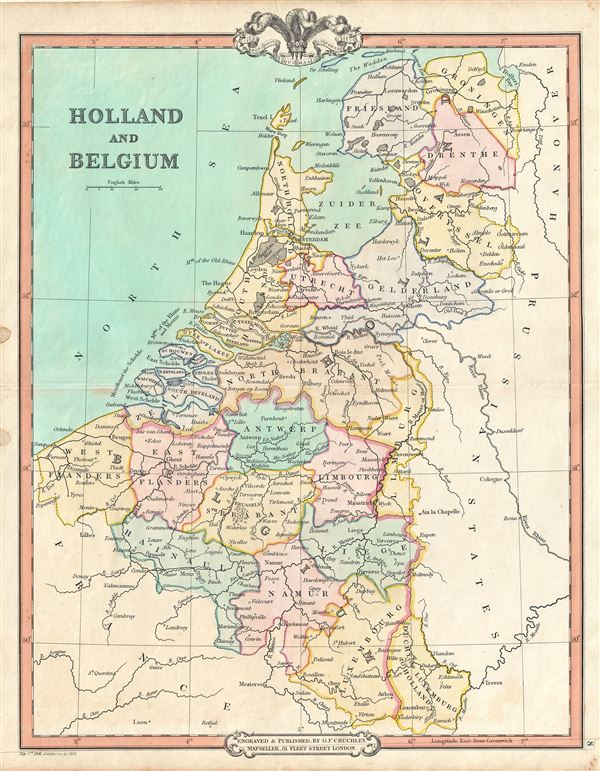
Holland and Belgium.
1850 (dated) 18 x 15 in (45.72 x 38.1 cm) 1 : 1050000
1850 (dated) 18 x 15 in (45.72 x 38.1 cm) 1 : 1050000
Description
A beautiful example of by George Frederick Cruchley's 1850 map of Holland (Netherlands) and Belgium. It covers the region from the North Sea to the Duchy of Luxemburg in the South. This map is color coded according the counties and provinces, showing important cities, towns, rivers, lakes, mountains and other important topographical features. Elevation is rendered in hachure.
In 1830, the Belgian Revolution led to the secession of Belgium from the United Kingdom of Netherlands and it's subsequently consolidation as the independent Kingdom of Belgium. Though Belgium had successfully attained self-rule, the Netherlands refused to recognize the new country until the 1839 Treaty of London.
Cruchley's General Atlas was unique for its period, employing a vivid color scheme extending even to the oceans, distinctive typography, and various uncommon decorative elements including a peacock feather crown and an imprint medallion, both of which break the printed border. Though many of the maps in this atlas are copyrighted in 1841, the atlas was first published in 1843 from the Cruchley office at 81 Fleet Street, London, and proving popular went through numerous reissues well into the 1850s.
Cartographer
George Frederick Cruchley (April 23, 1797 - June 16, 1880) was a London based book and map seller active in the middle part of the 19th century. Cruchley began his cartographic career as an apprentice at the venerable Aaroon Arrowsmith firm. Many of Cruchley's earliest maps bear the words 'From Arrowsmith's' on the imprint. In 1844, Cruchley acquired the massive stock of the important early 19th century firm of John Cary. Cruchley published his own maps as well as reissues of Cary's stock well into the 1870s. He is best known for his detailed plans of London, which in recent years have become increasingly scarce and desirable. Cruchley was based in London on 38 Ludgate Street until 1834 when he moved his offices to 81 Fleet Street. Shortly before his death in 1880 Cruchely auctioned (Hodgson's Auctions, Jan 16, 1877) his entire stock. Many of his map plates were thusly acquired by 'Gall and Inglis' who continued the Cruchley tradition well into the early 20th century. Cruchley's son, also George Frederick (1837 - 1882), continued to work as a book and map seller until his death. More by this mapmaker...
Source
Cruchley, G. F., Selection of Maps from Cruchley's General Atlas, for the use of Schools and Private Tuition, London, 1850.
Condition
Very good. Minor wear over original centerfold. Blank on verso.