1783 Janvier Map of Holland and Belgium
HollandBelgium-janvier-1783$200.00
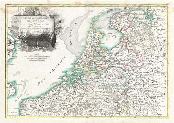

Title
Partie Septentrionale des Pays Bas, Comprenant Les Etats Generaus des Provinces Unies.
1783 (undated) 13 x 18 in (33.02 x 45.72 cm) 1 : 1130000
1783 (undated) 13 x 18 in (33.02 x 45.72 cm) 1 : 1130000
Description
A beautiful example of Jan Janvier's 1783 decorative map of the Low Countries or Pays Bas. This region covers modern day Holland and Belgium from Friesland south to France, west to the english Channel, and east to Germany. excellent detail is offered throughout with mountains, rivers, forests, national boundaries, regional boundaries, forts, and cities identified. Some undersea detail is included. A large decorative title cartouche depicting a merchant ship appears in the upper left quadrant. Drawn by Jan Janvier around 1783 for issue as plate no. 7 in Jean Lattre's 1783 issue of the Atlas Moderne.
CartographerS
Jean Denis Janvier (fl. 1746 - 1776), sometime also known as 'Robert', was a Paris based cartographer active in the mid to late 18th century. Janvier signed his maps Signor Janvier. By the late 18th century, Janvier was awarded the title of 'Geographe Avec Privilege du Roi' and this designation appears on many of his later maps. Janvier worked with many of the most prominent French, English and Italian map publishers of his day, including Longchamps, Faden, Lattre, Bonne, Santini, Zannoni, Delamarche, and Desnos. More by this mapmaker...
Jean Lattré (170x - 178x) was a Paris based bookseller, engraver, globe maker, calligrapher, and map publisher active in the mid to late 18th century. Lattré published a large corpus of maps, globes, and atlases in conjunction with a number of other important French cartographic figures, including Janvier, Zannoni, Bonne and Delamarche. He is also known to have worked with other European cartographers such as William Faden of London and the Italian cartographer Santini. Map piracy and copyright violations were common in 18th century France. Paris court records indicate that Lattré brought charges against several other period map publishers, including fellow Frenchman Desnos and the Italian map engraver Zannoni, both of whom he accused of copying his work. Lattré likes trained his wife Madame Lattré (né Vérard), as an engraver, as a late 18th century trade card promotes the world of 'Lattré et son Epouse.' Lattré's offices and bookshop were located at 20 rue St. Jaques, Paris, France. Later in life he relocated to Bordeaux. Learn More...
Source
Lattre, Jean, Atlas Moderne ou Collection de Cartes sur Toutes les Parties du Globe Terrestre, c. 1783.
Condition
Very good condition. Original centerfold exhibits toning. Blank on verso. Platemark visible. Some spotting near title.
References
Rumsey 2612.021. Phillips (Atlases) 664. National Maritime Museum, 215.