1927 Rand McNally Map of New York City, Holland Tunnel Opening
HollandTunnel-randmcnally-1927$400.00

Title
Map of Routes to the Holland Tunnel. / The Holland Tunnel Twin Tubes Map of Routes Description of Tunnel Toll Rates Traffic Regulations.
1927 (undated) 15.25 x 17.25 in (38.735 x 43.815 cm) 1 : 111000
1927 (undated) 15.25 x 17.25 in (38.735 x 43.815 cm) 1 : 111000
Description
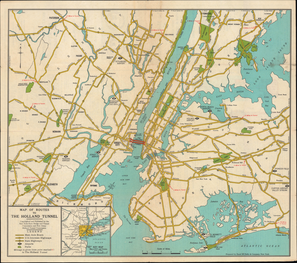
This is Rand McNally's c. 1927 map of New York City, produced to highlight the opening of the Holland Tunnel, the first direct automobile crossing of the Hudson River, and one of the great engineering marvels of its time.
Construction began on April 1, 1922. The tunnel was designed by Clifford Milburn Holland (1883 - 1924), who served as chief engineer on the project from 1919. Holland had prior experience designing tunnels under the East River for the subway. Holland's greatest challenge was ventilating carbon monoxide exhausted from automobiles, an issue he resolved with dozens of blowers and exhaust fans along with four massive ventilation shafts designed to be inconspicuous with exteriors resembling contemporary office buildings. At the same time, massive amounts of fresh air are blown into the tunnel so that the air fully circulates every minute and a half.
Holland worked so feverishly on the tunnel project that he suffered a nervous breakdown in 1924 and died shortly thereafter from a heart attack. In the wake of Holland's death, the tunnel project was renamed in his honor. His successor as chief engineer, Milton H. Freeman (1871 - 1925), also died after only four months on the job; a square near the tunnel's Manhattan entrance was named in his honor, Freeman Plaza. These tragedies left the Norwegian-born Ole Singstad (1882 - 1969) as chief engineer at the tunnel's opening. Singstad went on to design the Lincoln Tunnel, Brooklyn-Battery Tunnel, and Queens-Midtown Tunnel. Although the tunnel was opened some three years behind schedule and significantly over budget, it proved a popular and essential part of the infrastructure of New York City.
A Closer Look
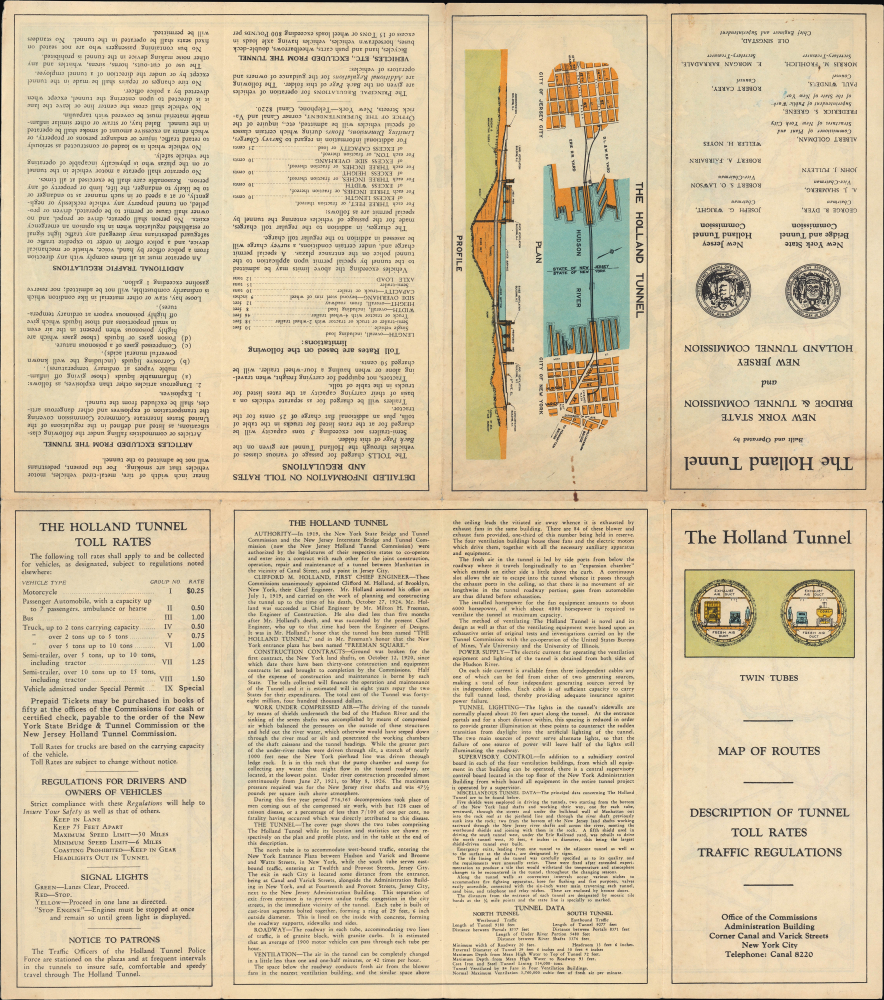
This map covers New York City and parts of Westchester County, New Jersey, and Long Island. Highways and other major roads are traced, with airports, parks, bridges, and neighborhoods identified. The Holland Tunnel is highlighted in red near center, while distances to the tunnel are recorded as red 'x's at highway and major road interchanges. A legend and inset map displaying the wider metropolitan area appear at bottom-left. Text on the verso describes the design and construction of the tunnel, toll rates, and regulations. This information is both informative and historically significant; for instance, the text states that the granite roadway was designed to accommodate 1900 vehicles per hour, though the demands placed on it soon exceeded these numbers, and today, the tunnel handles nearly double this number (largely due to increased night usage). The verso also includes a cross-section schematic of the tubes on the title panel, along with a plan and profile of the tunnel.Overcoming Engineering Challenges
Engineers in the early 20th century gained substantial expertise in tunnel construction in and around New York City through projects such as the Long Island Railroad, the Pennsylvania Railroad, and the Hudson and Manhattan Railroad (now part of the PATH system), which involved boring tunnels beneath both the Hudson and East Rivers. Their success provided impetus to early discussions of similar infrastructure for vehicular use. Explorations of a 'Hudson River Vehicular Tunnel' began as early as 1906 - remarkably prescient given the paucity of automobiles at that date. Planners were motivated by the inconvenience of relying on ferries for both passenger vehicles and freight. In addition to the usual wrangling over where to place the tunnel and how to fund its construction, designing a tunnel for automobiles presented other novel problems, in particular how to handle potentially deadly vehicular exhaust.Construction began on April 1, 1922. The tunnel was designed by Clifford Milburn Holland (1883 - 1924), who served as chief engineer on the project from 1919. Holland had prior experience designing tunnels under the East River for the subway. Holland's greatest challenge was ventilating carbon monoxide exhausted from automobiles, an issue he resolved with dozens of blowers and exhaust fans along with four massive ventilation shafts designed to be inconspicuous with exteriors resembling contemporary office buildings. At the same time, massive amounts of fresh air are blown into the tunnel so that the air fully circulates every minute and a half.
Holland worked so feverishly on the tunnel project that he suffered a nervous breakdown in 1924 and died shortly thereafter from a heart attack. In the wake of Holland's death, the tunnel project was renamed in his honor. His successor as chief engineer, Milton H. Freeman (1871 - 1925), also died after only four months on the job; a square near the tunnel's Manhattan entrance was named in his honor, Freeman Plaza. These tragedies left the Norwegian-born Ole Singstad (1882 - 1969) as chief engineer at the tunnel's opening. Singstad went on to design the Lincoln Tunnel, Brooklyn-Battery Tunnel, and Queens-Midtown Tunnel. Although the tunnel was opened some three years behind schedule and significantly over budget, it proved a popular and essential part of the infrastructure of New York City.
Publication History and Census
This map was designed by Rand McNally for the New York State Bridge and Tunnel Commission and the New Jersey Holland Tunnel Commission. It is undated but most likely corresponds to the opening of the tunnel in November 1927. Curiously, the map displays the Bayonne Bridge in New Jersey as 'under construction' when construction only began on it in 1928 but makes no mention of the George Washington Bridge, on which construction began in September 1927. Other details further confuse a precise dating, such as Curtiss Airport at Valley Stream on Long Island, which suggests a slightly later date. In any event, these details remain consistent with a date of 1927-1928. The map is scarce, only being noted among the holdings of the New York Public Library, Brooklyn Public Library, and Newberry Library. No known market history.Cartographer
Rand, McNally and Co. (fl. 1856 - present) is an American publisher of maps, atlases and globes. The company was founded in 1856 when William H. Rand, a native of Quincy, Massachusetts, opened a print shop in Chicago. Rand hired the recent Irish immigrant Andrew McNally to assist in the shop giving him a wage of 9 USD per week. The duo landed several important contracts, including the Tribune's (later renamed the Chicago Tribune) printing operation. In 1872, Rand McNally produced its first map, a railroad guide, using a new cost effective printing technique known as wax process engraving. As Chicago developed as a railway hub, the Rand firm, now incorporated as Rand McNally, began producing a wide array of railroad maps and guides. Over time, the firm expanded into atlases, globes, educational material, and general literature. By embracing the wax engraving process, Rand McNally was able to dominate the map and atlas market, pushing more traditional American lithographic publishers like Colton, Johnson, and Mitchell out of business. Eventually Rand McNally opened an annex office in New York City headed by Caleb S. Hammond, whose name is today synonymous with maps and atlases, and who later started his own map company, C. S. Hammond & Co. Both firms remain in business. More by this mapmaker...
Condition
Very good. Light wear along original fold lines. Verso repair to a fold separation. Very slight loss at a few fold intersections. Text and map of the Holland Tunnel on verso.
References
OCLC 288956600.