This item has been sold, but you can get on the Waitlist to be notified if another example becomes available, or purchase a digital scan.
1852 Meyer Map of the Duchy of Holstein, Germany
Holstein-meyer-1852$50.00

Title
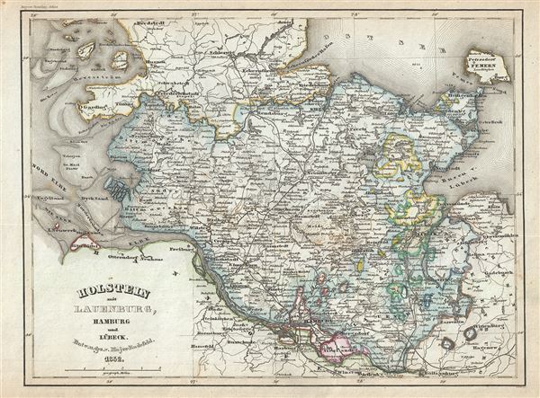
Holstein mit Lauenburg, Hamburg und Lubeck.
1852 (dated) 8.5 x 11 in (21.59 x 27.94 cm) 1 : 800000
1852 (dated) 8.5 x 11 in (21.59 x 27.94 cm) 1 : 800000
Description
This is a scarce 1852 map of the Holstein, Germany. It covers from Tonning south as far as Hamburg. Includes the Duchy of Holstein, Lauenburg, Hamburg and Lubeck. This extremely detailed map notes important cities, towns, rivers, roads, coastal features and other important topographical features. Various battlegrounds are also identified.
During the time this map was made, the region was in the midst of the First Schleswig War between Prussia, Germany and the duchies of Holstein and Schleswig against the Kingdom of Denmark. In 1848, when the King of Denmark, Frederick VII, proposed that the Duchies of Schleswig and Holstein be formally recognized as part of the Danish Kingdom, the predominantly German population of the two duchies rebelled for a free constitution, resulting in war. Denmark ultimately won the war and retained control of Schleswig-Holstein following the London Protocol of 1852. In 1863 Denmark once again tried to integrate the Duchy of Schleswig into the Kingdom of Denmark by passing the November Constitution, leading to the Second War of Schleswig in 1864 between Austria and Prussia on one side and Denmark on the other. In the end Denmark surrendered control over Schleswig, Lauenburg and Holstein to Prussia and Austria. The Second War of Schleswig would eventually culminate into the Austro-Prussian War of 1866 and Prussia would annex both Schleswig and Holstein to create the new province of Schleswig-Holstein.
This map was issued in Meyer's Zeitung Atlas. Although all the maps in this atlas are not individually dated, the title page and maps were often updated while the imprint with the date was not, causing confusion to the exact date for some of the maps. Moreover some maps in the atlas were taped in at a later date as an update to the atlas. We have dated the maps in this collection to the best of our ability.
Cartographer
Joseph Meyer (May 9, 1796 - June 27, 1856) was a German industrialist, merchant, and publisher, active in Germany in the early to mid 19th century. He is best known for publishing the encyclopedia Meyers Conversation-Lexicon. Born in Gotha, Germany, Meyer was educated as a merchant in Frankfurt am Main. He moved to London in 1816, but returned to Germany in 1820 after his stock speculations and business adventures fell through. Once back in Germany, he began by investing in the textile trade (1820 - 24). Meyer began creating business plans concerning how to start railways soon after the first steam-hauled railway began operation in December 1835. He founded the Deutsche Eisenbahnschienen-Compangie auf Actien (German Railway Rail joint stock company) in 1845. Meyer also found great success as a publisher, utilizing the system of serial subscriptions to publications, a new idea for the time. He founded a company, Bibliographisches Institut in Gotha in 1825, which published several versions of the Bible, works of classical literature, atlases, the world in pictures on steel engravings, and an encyclopedia. He moved the Institut from Gotha to Hildburghausen in 1828. He published several atlases, including Meyer's Groẞer Hand-Atlas (1843 - 1860). In 1848, he supported the Springtime of the Peoples Revolutions that took place throughout Germany and much of Europe. When the revolutions failed in 1849, Meyer was briefly imprisoned for his support of revolutionary activities. The revolutions also began to take a toll on Meyer's business interests, and when he died, in 1856, the Bibliographisches Institut was struggling financially. His son, Herrmann Julius Meyer, took over the firm, spearheading a rapid recovery. This, and other businesses prospered under Herrmann Julius (April 4, 1826 - March 12, 1909) and when he died in 1909, he led the richest family in Saxony, with more total wealth than the King of Saxony More by this mapmaker...
Source
Meyer, J., Meyer's Zeitung Atlas, 1852.
Meyer's Zeitung Atlas, formally titled Neuster Zeitungs-Atlas Fuer Alte und Neue Erdkunde was a popular German hand-atlas published in Heidelberg by Joseph Meyer between, roughly, 1848 and 1859. The atlas is well engraved in the German style with exceptionally dense detail and minimal decoration. Meyer's Atlas, and its constituent maps, are typically very difficult to date as later editions often contain earlier maps and earlier editions later paste-in updates. That said, the atlas' frequent updates and publication run during a turbulent decade provide a noteworthy cartographic record of the period.
Condition
Very good. Minor toning and spotting at places.