1540 / 1552 Münster Map of the Holy Land
HolyLand-munster-1552$1,100.00

Title
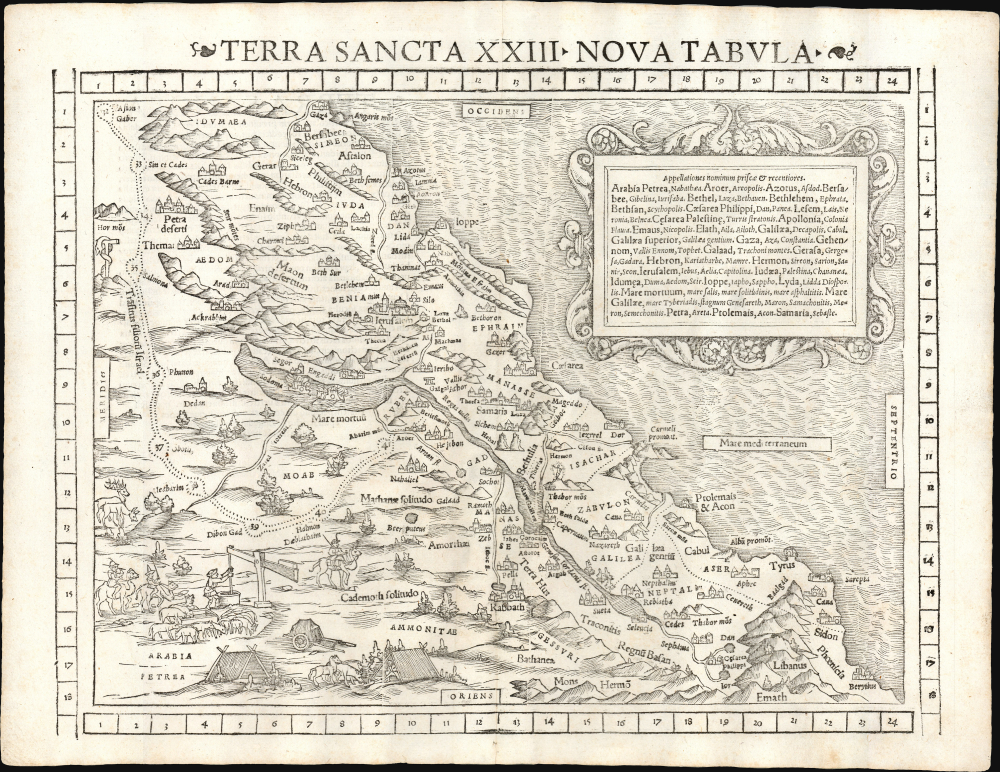
Terra Sancta XXIII Nova Tabula.
1552 (undated) 11.5 x 14.75 in (29.21 x 37.465 cm) 1 : 30000000
1552 (undated) 11.5 x 14.75 in (29.21 x 37.465 cm) 1 : 30000000
Description
This is Sebastian Münster's 1540 map of the Holy Land, here in the distinctive 1552 state (with coordinate bars) appearing in the last edition of Münster's Ptolemy. This attractive and evocative map was broadly influential. While predated by its source, Jacob Ziegler's 1532 Holy Land, Münster improved both on the aesthetics and content of the map. Moreover, the inclusion of this map both in Münster's Geographia and in his Cosmographia extended this geography far beyond the reach of Ziegler's scholarly works. Among the earliest printed maps of this part of the world, Münster's is the most decorative.
As is often the case with the tabulae modernae appearing in Münster's Geographia,, the map includes an extensive list (in an attractive cartouche) of the place names appearing on the map, comparing modern appellations with ancient ones.
A Closer Look
This west-oriented map depicts Palestine on both sides of the Jordan River. The Mediterranean coast is drawn from Gaza to Beirut. Mountains and cities are indicated pictorially. Shepherds, camel drivers, and travelers' tents are pictured in the lower left. As is the case with most early European maps of the Holy Land, the map's focus is less on contemporary Palestine and more on the Biblical era. The region is divided between the 12 tribes of Judaea. Jerusalem is prominent, as is Bethlehem. The final stretches of the Exodus are mapped, and its last ten stations are numbered. Along its route, Moses' bronze snake (Numbers 21:9) is depicted. The doomed Sodom and Gomorrah are shown in the Dead Sea.As is often the case with the tabulae modernae appearing in Münster's Geographia,, the map includes an extensive list (in an attractive cartouche) of the place names appearing on the map, comparing modern appellations with ancient ones.
Publication History and Census
This map was prepared for the 1540 edition of Münster's Geographia, appearing in all four editions of that work. Only the 1552 edition includes the coordinate borders visible on the present example. The map also appeared in the first editions of Münster's Cosmographia, but surprisingly, it was omitted from that work after 1550, reappearing only in the 1569, 1572, and 1574 editions. Thus, among Münster's full-size maps, this is among the scarcest. While editions of Geographia and Cosmographiaare well represented in institutional collections, OCLC lists 27 copies of the 1552 Geographia. Only two examples of this 1552 state of the separate map are cataloged in OCLC at the Sachsische Landesbibliothek and the Bayerische Staatsbibliothek.CartographerS
Sebastian Münster (January 20, 1488 - May 26, 1552), was a German cartographer, cosmographer, Hebrew scholar and humanist. He was born at Ingelheim near Mainz, the son of Andreas Munster. He completed his studies at the Eberhard-Karls-Universität Tübingen in 1518, after which he was appointed to the University of Basel in 1527. As Professor of Hebrew, he edited the Hebrew Bible, accompanied by a Latin translation. In 1540 he published a Latin edition of Ptolemy's Geographia, which presented the ancient cartographer's 2nd century geographical data supplemented systematically with maps of the modern world. This was followed by what can be considered his principal work, the Cosmographia. First issued in 1544, this was the earliest German description of the modern world. It would become the go-to book for any literate layperson who wished to know about anywhere that was further than a day's journey from home. In preparation for his work on Cosmographia, Münster reached out to humanists around Europe and especially within the Holy Roman Empire, enlisting colleagues to provide him with up-to-date maps and views of their countries and cities, with the result that the book contains a disproportionate number of maps providing the first modern depictions of the areas they depict. Münster, as a religious man, was not producing a travel guide. Just as his work in ancient languages was intended to provide his students with as direct a connection as possible to scriptural revelation, his object in producing Cosmographia was to provide the reader with a description of all of creation: a further means of gaining revelation. The book, unsurprisingly, proved popular and was reissued in numerous editions and languages including Latin, French, Italian, and Czech. The last German edition was published in 1628, long after Münster's death of the plague in 1552. Cosmographia was one of the most successful and popular books of the 16th century, passing through 24 editions between 1544 and 1628. This success was due in part to its fascinating woodcuts (some by Hans Holbein the Younger, Urs Graf, Hans Rudolph Manuel Deutsch, and David Kandel). Münster's work was highly influential in reviving classical geography in 16th century Europe, and providing the intellectual foundations for the production of later compilations of cartographic work, such as Ortelius' Theatrum Orbis Terrarum Münster's output includes a small format 1536 map of Europe; the 1532 Grynaeus map of the world is also attributed to him. His non-geographical output includes Dictionarium trilingue in Latin, Greek, and Hebrew, and his 1537 Hebrew Gospel of Matthew. Most of Munster's work was published by his stepson, Heinrich Petri (Henricus Petrus), and his son Sebastian Henric Petri. More by this mapmaker...
Jacob Ziegler (c. 1470 - 1549) was a Bavarian humanist and geographer. He received his education at the University of Ingolstadt and was friends with the scholar Willibald Pirckheimer (1470-1530). Despite having been a courtier to Pope Leo X, he would later embrace Protestantism. He taught at Vienna; claims that he had been a professor of mathematics at Uppsala University, while plausible, have not gone unchallenged. He is best known for his geographical treatise Quae intus continentur Syria, Palestina, Arabia, Aegyptus, Schondia, Holmiae... , which was published in Strasbourg in 1532 and contained new and particularly influential maps of Scandinavia and the Holy Land. His work would be adopted by Sebastian Münster and even Gerard Mercator, despite the latter's acknowledgment of Ziegler's errors. Learn More...
Heinrich Petri (1508 - 1579) and his son Sebastian Henric Petri (1545 – 1627) were printers based in Basel, Switzerland. Heinrich was the son of the printer Adam Petri and Anna Selber. After Adam died in 1527, Anna married the humanist and geographer Sebastian Münster - one of Adam's collaborators. Sebastian contracted his stepson, Henricus Petri (Petrus), to print editions of his wildly popular Cosmographia. Later Petri, brought his son, Sebastian Henric Petri, into the family business. Their firm was known as the Officina Henricpetrina. In addition to the Cosmographia, they also published a number of other seminal works including the 1566 second edition of Nicolaus Copernicus's De Revolutionibus Orbium Coelestium and Georg Joachim Rheticus's Narratio. Learn More...
Source
Münster, S., Geographia, (Basel: Petri) 1552.
Following in the footsteps of Martin Waldseemuller and Lorent Fries before him, Sebastian Munster edited and published a modernized version of Claudius Ptolemy's Geographia. This appeared in six Latin editions in 1540, 1541, 1542, 1545, 1551 and 1552. According to Karrow, Munster based the text on the Latin translation of Willibald Pirkheimer, but he carefully collated it with previous editions, adding notes of his own. The first three editions contained 48 maps, consisting of 27 based on Ptolemy's ancient geography, and 21 maps based on modern geographical knowledge. The latter three editions contained 54 maps, comprised of the same ancient works but with six of the modern maps discarded, and twelve new ones added. For the collector, the modern maps are of sharpest interest. Some were based on Waldseemuller's geography, but many were based on Munster's own surveys and those of other European geographers whose assistance Munster had been able to enlist. Most of these would be reprised in Munster's magnum opus, Cosmographia Universalis. A disproportionate number of Munster's modern maps show contemporary geographical knowledge of the their respective areas for the very first time: The first map to show the continents of the Western Hemisphere; the first map to focus on the continent of Asia; the first modern map to name the Pacific Ocean. Even in cases where earlier maps exist, Munster's works very often remain the earliest such acquirable by the collector.
Condition
Excellent.
References
OCLC 165596077. Rumsey 11623.098 (1540) Laor, E., Maps of the Holy Land: Cartobibliography of Printed Maps, 1475 - 1900, #618.