This item has been sold, but you can get on the Waitlist to be notified if another example becomes available, or purchase a digital scan.
1734 Seutter Map of the Holy Land with Beautifully Engraved Biblical Scenes
HolyLand-seutter-1734$250.00

Title
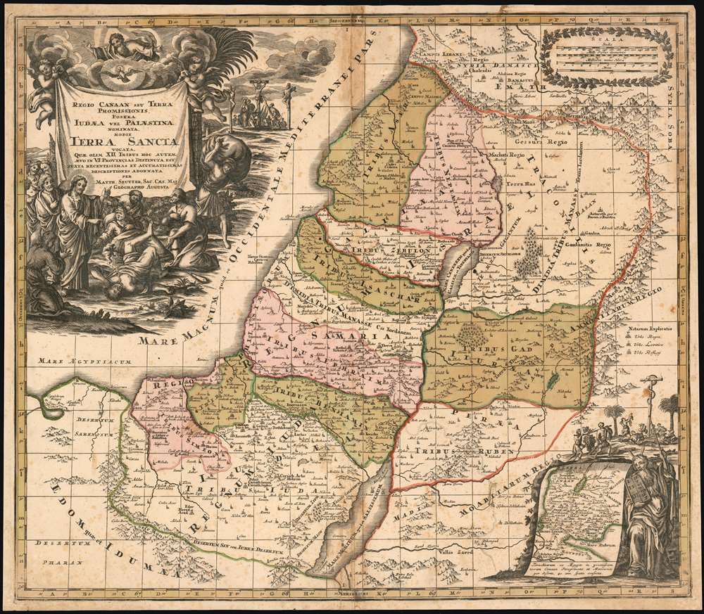
Regio Canaan Seu Terra Promissionis, Postea Iudaea Vel Palestina Nominata, Hodie Terra Sancta Vocata : Quae Olim XII Hoc Autem Aevo In VI Provincias Distincta Est Iuxta Recentissimas et Accuraissimas Descriptiones Adornata Per Matth. Seutter, Sac. Caes. Maj. Geographo Augusta.
1734 (undated) 19.75 x 22.75 in (50.165 x 57.785 cm) 1 : 745000
1734 (undated) 19.75 x 22.75 in (50.165 x 57.785 cm) 1 : 745000
Description
This 1734 Seutter map of the Holy Land reproduces the authoritative cartography of Nicolas Sanson with the bold, richly decorative cartouches of Seutter’s master engraver, Gottfried Rogg. The primary map shows Judaea, divided into the territories of the 12 Tribes. The tribal regions are distinguished from one another in rich, period wash and outline color. Mountains and forests are shown pictorially. The map uses a key to distinguish Royal Cities, Cities of Refuge, and Levite Cities from each other. It includes, also, cities the Bible records were destroyed: Sodom, Gomorrah, and Seboim. All of these can be found within the bounds of the Dead Sea. The superbly engraved cartouche shows a New Testament scene of Christ drawing a demon - appearing in the form of a wriggling, winged creature in a puff of smoke - out of the mouth of a possessed man, while a crowd of onlookers gasp in amazement. An inset map in the lower right shows the track of the Israelites out of Egypt and into Canaan: Moses appears to the right of the inset, and above is a depiction of Numbers 21:4-9 in which the Israelites gather close to a brazen serpent, set up by Moses to protect them from the flying fiery serpents assailing them. The presence of this allegory here is not accidental: it is placed in support of the crucifixion scene appearing in the background of the main cartouche (in John 3:14-16 an explicit comparison was drawn between the raising of the Brazen Serpent and the Crucifixion.)
Publication History and Census
This map first appeared in Seutter's Atlas Novus in 1728; We identify two further states corresponding to his 1734 Grosser Atlas and his c. 1740 Atlas Novus The present example corresponds to the 1734. Perhaps five copies of this state are clearly identified in institutional collections by OCLC, but this number may in actuality be greater, as differing states of this map are seldom catalogued precisely.CartographerS
Matthäus Seutter (1678 - 1757) was one of the most important and prolific German map publishers of the 18th century. Seutter was born the son of a goldsmith but apprenticed as a brewer. Apparently uninspired by the beer business, Seutter abandoned his apprenticeship and moved to Nuremberg where he apprenticed as an engraver under the tutelage of the prominent J. B. Homann. Sometime in the early 1700s Seutter left Homann to return to Augsburg, where he worked for the prominent art publisher Jeremiad Wolff (1663 - 1724), for whom he engraved maps and other prints. Sometime around 1717 he established his own independent cartographic publishing firm in Augsburg. Though he struggled in the early years of his independence, Seutter's engraving skill and commitment to diversified map production eventually attracted a substantial following. Most of Seutter's maps are heavily based upon, if not copies of, earlier work done by the Homann and De L'Isle firms. Nonetheless, by 1731/32 Seutter was one of the most prolific publishers of his time and was honored by the German Emperor Karl VI who gave him the title of Imperial Geographer, after which most subsequent maps included the Avec Privilege designation. Seutter continued to publish until his death, at the height of his career, in 1757. Seutter had two engraver sons, Georg Matthäus Seutter (1710 - 173?) and Albrecht Carl Seutter (1722 - 1762). Georg Matthäus quit the business and relocated to Woehrdt in 1729 (and probably died shortly thereafter), leaving the family inheritance to his wastrel brother Albrecht Carl Seutter, who did little to advance the firm until in own death in 1762. Following Albrecht's death, the firm was divided between the established Johann Michael Probst (1727 - 1776) firm and the emerging firm of Tobias Conrad Lotter. Lotter, Matthäus Seutter's son-in-law, was a master engraver and worked tirelessly on behalf of the Suetter firm. It is Lotter, who would eventually become one of the most prominent cartographers of his day, and his descendants, who are generally regarded as the true successors to Matthäus Seutter. (Ritter, M. Seutter, Probst and Lotter: An Eighteenth-Century Map Publishing House in Germany., "Imago Mundi", Vol. 53, (2001), pp. 130-135.) More by this mapmaker...
Nicolas Sanson (December 20, 1600 - July 7, 1667) and his descendants were the most influential French cartographers of the 17th century and laid the groundwork for the Golden Age of French Cartography. Sanson was born in Picardy, but his family was of Scottish Descent. He studied with the Jesuit Fathers at Amiens. Sanson started his career as a historian where, it is said, he turned to cartography as a way to illustrate his historical studies. In the course of his research some of his fine maps came to the attention of King Louis XIII who, admiring the quality of his work, appointed Sanson Geographe Ordinaire du Roi. Sanson's duties in this coveted position included advising the king on matters of geography and compiling the royal cartographic archive. In 1644, he partnered with Pierre Mariette, an established print dealer and engraver, whose business savvy and ready capital enabled Sanson to publish an enormous quantity of maps. Sanson's corpus of some three hundred maps initiated the golden age of French mapmaking and he is considered the 'Father of French Cartography.' His work is distinguished as being the first of the 'Positivist Cartographers,' a primarily French school of cartography that valued scientific observation over historical cartographic conventions. The practice result of the is less embellishment of geographical imagery, as was common in the Dutch Golden Age maps of the 16th century, in favor of conventionalized cartographic representational modes. Sanson is most admired for his construction of the magnificent atlas Cartes Generales de Toutes les Parties du Monde. Sanson's maps of North America, Amerique Septentrionale (1650), Le Nouveau Mexique et La Floride (1656), and La Canada ou Nouvelle France (1656) are exceptionally notable for their important contributions to the cartographic perceptions of the New World. Both maps utilize the discoveries of important French missionaries and are among the first published maps to show the Great Lakes in recognizable form. Sanson was also an active proponent of the insular California theory, wherein it was speculated that California was an island rather than a peninsula. After his death, Sanson's maps were frequently republished, without updates, by his sons, Guillaume (1633 - 1703) and Adrien Sanson (1639 - 1718). Even so, Sanson's true cartographic legacy as a 'positivist geographer' was carried on by others, including Alexis-Hubert Jaillot, Guillaume De L'Isle, Gilles Robert de Vaugondy, and Pierre Duval. Learn More...
Gottfried Rogg (1669-1742) was an Augsburg goldsmith, engraver and publisher. He was known for his decorative engraving, in particular having engraved a large number of the maps for Matthias Seutter’s atlases. Learn More...
Source
Seutter, M. Grosser Atlas(Augsburg) 1734
Condition
Good. Some foxing and centerfold stains.
References
cfRumsey 12041.060. OCLC 159823455. Laor 720. Nebenzahl 50.