This item has been sold, but you can get on the Waitlist to be notified if another example becomes available, or purchase a digital scan.
1864 Belcher Nautical Map of Hong Kong Island
HongKong-belcher-1864$9,000.00

Title
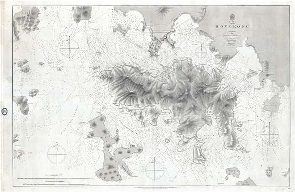
China Hong Kong Surveyed by Captn. Sir Edward Belcher in H.M.S. Sulphur 1841.
1864 (dated) 25 x 37 in (63.5 x 93.98 cm) 1 : 32000
1864 (dated) 25 x 37 in (63.5 x 93.98 cm) 1 : 32000
Description
An iconic map of the utmost importance and rarity, this is the 1864 issue of Edward Belcher's 1843 nautical map of Hong Kong (香港) and vicinity. Belcher's 1841 study is the first detailed British survey of Hong Kong and played a significant role in the British acquisition of the Crown Colony. The map covers all of Hong Kong Island (香港島) as well as the Kowloon (Kaulung /九龍) Peninsula and, either in part or full, the adjacent island of Lan Tao (大嶼山), Peng Chau (坪洲), Hei Ling Chau (喜靈洲), Lamma (南丫島), Sheung Sze Mun (雙四門), Po Toi (蒲苔羣島), and Tung Lung Chau (東龍洲). The map offers impressive detail to the level of individual buildings, especially Victoria, Central, and on the Kowloon Peninsula. Countless depth soundings in fathoms throughout.
Belcher surveyed Hong Kong Island and Harbour after landing the bombing and surveying vessel H.M.S. Sulphur on Possession Point on January, 26, 1841. At the height of the First Opium War (1839–42), Belcher's was the first British fleet to land on and take possession of Hong Kong for the British Crown. Belcher may have been unaware of the long-term significance of his conquest, but he was certainly a keen observer and recognized Hong Kong's strategic significance and commercial potential. As such, his impressive map, first published in May of 1843, set the standard upon which most subsequent nautical charts of Hong Kong were based well into the 20th century.
This chart has a long publication history and appeared in many editions, all of which are today exceedingly rare. The basic cartography dates to Belcher's original 1841 survey, which was not published in 1843. Corrections and revisions were added from 1857-1861, with this edition appearing in January of 1864. Although all examples well into the 20th century follow Belcher's initial survey lines, the differences between editions are significant. Soundings are corrected, new developments and streets are added to Hong Kong and Kowloon, and, in later editions, insets were incorporated.
This map was printed by J. and C. Walker for the British Admiralty Hydrographic Office as chart number 1466. The original seller for this chart appears to have been J. D. Potter, of King Street, Tower Hill, London. It subsequently found its way to Melbourne, Australia, where it was sold by Blundell and Ford, Agents for the sale of Admiralty Charts. All examples of this chart in all editions are extremely rare.
CartographerS
Sir Edward Belcher (February 27, 1799 – March 18, 1877) was a British naval officer, scientist, explorer, and marine surveyor active in the middle part of the 19th century. Belcher was born in Halifax, Nova Scotia, to a proud seafaring family. He entered the Royal Navy in 1812, at just 13 years of age. Thirteen years later, in 1825, he was assigned as official surveyor to the Frederick William Beechey expedition to the Pacific and the Bering Strait. By 1836 he was in command of his own surveying (and bombing) ship, the H.M.S. Sulphur in western Africa and the Pacific coast of South America. The Sulphur was ordered back to England via the Trans-Pacific Route in 1839. On the way, he was delayed and reassigned to China to take part in the First Opium War (1839 – 1842). During this period, on January 26 of 1841, he landed on Possession Point on the northern shore of Hong Kong Island. During this visit he made the influential first British survey of Hong Kong Harbor. On returning to England he was Knighted for his services and reassigned to the HMS Samarang to complete survey work throughout the East Indies, but most specifically in the Philippines. In 1852 he commanded the last and largest Admiralty expedition in search of the lost Arctic Explorer Sir John Franklin. The expedition had five ships, four of which were lost to the Arctic ice. Like all British naval officers who lose a ship, he was court-martialed on his return to England. Although exonerated, he never received another command. He died in London at the age of 78. Belcher is commemorated in Hong Kong through Belcher's Street, Belcher Bay and The Belcher's in Kennedy Town. His name is also commemorated in the Belcher Islands, in the Canadian Arctic. He is also commemorated with a plaque in the Admiralty Garden. Following his last active service, he was appointed Knight Commander of the Order of the Bath in 1867 and an admiral in 1872. More by this mapmaker...
The British Admiralty Office (1795 - Present) or the United Kingdom Hydrographic Office refers to the Branch of the English government that is responsible for the command of the British Navy. In 1795 King George III created the United Kingdom Hydrographic Office, known in short as the U.K.H.O., to provide top notch nautical charts to the vast Royal Navy. Prior the founding of the Admiralty the surveying and creation of nautical charts was primarily a commercial venture wherein the cartographer himself, more of than not, actually financed the printing of his own material. The great navigator Cook himself is known to have scrambled for funds to publish his own seminal charts - the most important and advanced of the period. The system of privately funded nautical mapping and publishing left vast portions of the world uncharted and many excellent charts unpublished. King George III, responding significant loss in trade revenue related to shipwrecks and delay due to poor charts, recognized the need for an institutionalized government sponsored cartographic agency - the Admiralty. The first head of the Admiralty, a position known as Hydrographer, was the important cartographer Alexander Dalrymple. Dalrymple started by organizing and cataloging obtainable charts before initiating the laborious process of updating them and filling in the blanks. The first official Admiralty Chart appeared in 1800 and detailed Quiberon Bay in Brittany. By 1808 the position of Hydrographer fell to Captain Thomas Hurd. Hurd advocated the sale of Admiralty charts to the general public and, by the time he retired in 1829, had issued and published some 736 charts. Stewardship of the organization then passed to Rear Admiral Sir Francis Beaufort. It was under Beaufort's administration that the Admiralty truly developed as a "chart making" as opposed to a "chart cataloging" institution. Beaufort held his post from 1829 to 1854. In his 25 years at the Admiralty Beaufort created nearly 1500 new charts and sponsored countless surveying and scientific expeditions - including the 1831 to 1836 voyage of the H.M.S. Beagle. By 1855 the Admiralty's chart catalog listed some 1,981 charts. Learn More...
John Walker (1787 - April 19, 1873) was a British map seller, engraver, lithographer, hydrographer, geographer, draughtsman, and publisher active in London during the 19th century. Walker published both nautical charts and geographical maps. His nautical work is particularly distinguished as he was an official hydrographer for the British East India Company, a position, incidentally, also held by his father of the same name. Walker's maps, mostly published after 1827, were primarily produced with his brothers Charles Walker and Alexander Walker under the imprint J. and C. Walker. Among their joint projects are more than 200 maps for the influential Society for the Diffusion of Useful Knowledge Atlas (SDUK). In addition they published numerous charts for James Horsburgh and the British Admiralty Hydrographic Office, including Belcher's important map of Hong Kong and Carless' exploratory map of Karachi. The J. and C. Walker firm continued to publish after both Walkers died in the 1870s. Learn More...
Condition
Very good. Backed on linen. A few minor discolorations, else fine.
References
OCLC 54871290.