This item has been sold, but you can get on the Waitlist to be notified if another example becomes available, or purchase a digital scan.
1874 Sudo Manuscript Map of Hong Kong
HongKong-sudo-1874$1,750.00

Title
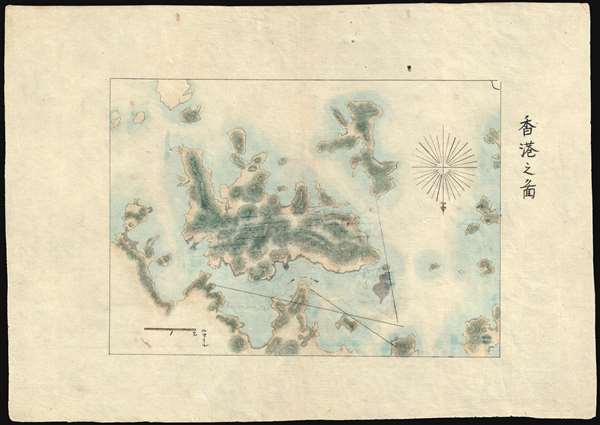
香港之圖 / Map of Hong Kong
1874 (undated) 9 x 12 in (22.86 x 30.48 cm) 1 : 114000
1874 (undated) 9 x 12 in (22.86 x 30.48 cm) 1 : 114000
Description
A finely executed early Japanese manuscript map of Hong Kong and some of the surrounding islands prepared around 1874 - likely the earliest Japanese map to focus specifically on Hong Kong. Oriented to the south, the map covers all of Hong Kong Island, Kowloon, and some of the surrounding lands. The map includes no development, suggesting the source must be the 1841 first edition of Sir. Edward Belcher's historic plan, which it also matches in scope of coverage.
Connections to Le Gendre and the Taiwan Punitive Expedition
The present example was found in a collection of manuscript maps relating to the American consul to Qing Taiwan, Charles William Le Gendre (1830–1899). Le Gendre relocated to Japan in the early 1870s, where he consulted on Formosa cartography, producing a number of important maps that were subsequently translated and transcribed into Japanese / Chinese and used to plan and execute the 1874 Taiwan Punitive Expedition against the Paiwan tribespeople of southern Formosa. Although this map does not directly relate to the Punitive Expedition, it is clearly in the same hand as the other charts, making it easy to date with reasonable confidence.Sudo Katsuzō (湏藤 or 湏藤勝三)
Some of the other maps in the series are attributed to a gentleman named Sudo Katsuzō (湏藤 or 湏藤勝三) and this map is also likely by his hand, although we have found no trace of him in the historical record. Sudo apparently died of illness shortly after the maps were made, at just 26, so it is not surprising that little is recorded regarding his history. His maps were subsequently collected by his brother and remained in the family until recently.Condition
Very good.