1929 Admiralty Nautical Chart or Map of Hong Kong: Victoria and Kowloon
HongKongKowloon-admiralty-1929$3,000.00

Title
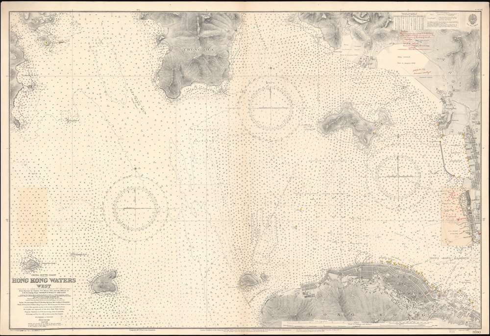
China-South Coast. Hong Kong Waters West.
1929 (dated) 27.5 x 40.5 in (69.85 x 102.87 cm) 1 : 12500
1929 (dated) 27.5 x 40.5 in (69.85 x 102.87 cm) 1 : 12500
Description
A detailed 1929 British Admiralty nautical chart or maritime map of Hong Kong Harbor and Kowloon. The map covers from eastern Lan Tau Island to Kowloon and from Tsing Yi (青衣, Chung Hue) to Victoria (Hong Kong Central, Sai Wan, Sai Ying Pun, and Sheung Wan. It exhibits copious c. 1930 manuscript updates in the vicinity of Kowloon, including a heavily annotated pastedown.
A scarce item. We have identified examples in the British Museum and the Hong Kong Maritime Museum. It does not appear in the OCLC. No other examples in any edition are known.
Urban Development
This map is noteworthy for being one of the few nautical charts of Hong Kong to exhibit extensive detail regarding the urban development of Hong Kong Victoria and Kowloon. In Hong Kong it notes land reclamation projects in Central and in Sai Wan, both then at the limits of the urban development. The map identifies factories, government offices, civil facilities, the Queen's College, the cricket grounds, markets and military instillations. One site 'APC' is identified in red manuscript, possibly 'Asia Pacific Cargo.' A pier has been added in Kowloon. A manuscript note suggests that the buoy locations of the west of the Man of War anchorages are incorrect.Census and Publication History
This chart was originally published in 1903 under the title Hong Kong Harbour - West. The chart name changed in 1920 to the present Hong Kong Waters West. It is based upon original survey work completed by the Royal Navy under Captains W. U. Moore and Morris H. Smith, and Lieutenants P. L. Hancock an F. A. Reyne. The original survey work was completed between 188 and 1893, with update surveys completed in 1902 and 1911. The present example exhibits minor updates to 1929, as well as a pastedown containing manuscript revisions and annotations to about 1930. Represents Admiralty chart no. 3280.A scarce item. We have identified examples in the British Museum and the Hong Kong Maritime Museum. It does not appear in the OCLC. No other examples in any edition are known.
Cartographer
The British Admiralty Office (1795 - Present) or the United Kingdom Hydrographic Office refers to the Branch of the English government that is responsible for the command of the British Navy. In 1795 King George III created the United Kingdom Hydrographic Office, known in short as the U.K.H.O., to provide top notch nautical charts to the vast Royal Navy. Prior the founding of the Admiralty the surveying and creation of nautical charts was primarily a commercial venture wherein the cartographer himself, more of than not, actually financed the printing of his own material. The great navigator Cook himself is known to have scrambled for funds to publish his own seminal charts - the most important and advanced of the period. The system of privately funded nautical mapping and publishing left vast portions of the world uncharted and many excellent charts unpublished. King George III, responding significant loss in trade revenue related to shipwrecks and delay due to poor charts, recognized the need for an institutionalized government sponsored cartographic agency - the Admiralty. The first head of the Admiralty, a position known as Hydrographer, was the important cartographer Alexander Dalrymple. Dalrymple started by organizing and cataloging obtainable charts before initiating the laborious process of updating them and filling in the blanks. The first official Admiralty Chart appeared in 1800 and detailed Quiberon Bay in Brittany. By 1808 the position of Hydrographer fell to Captain Thomas Hurd. Hurd advocated the sale of Admiralty charts to the general public and, by the time he retired in 1829, had issued and published some 736 charts. Stewardship of the organization then passed to Rear Admiral Sir Francis Beaufort. It was under Beaufort's administration that the Admiralty truly developed as a "chart making" as opposed to a "chart cataloging" institution. Beaufort held his post from 1829 to 1854. In his 25 years at the Admiralty Beaufort created nearly 1500 new charts and sponsored countless surveying and scientific expeditions - including the 1831 to 1836 voyage of the H.M.S. Beagle. By 1855 the Admiralty's chart catalog listed some 1,981 charts. More by this mapmaker...
Condition
Very good. Manuscript and pastedown updates. Original centerfold.
References
OCLC 176920917. Hong Kong Maritime Museum, 2008.0285.0002. Charting the Pearl River Delta (Hong Kong Maritime Museum), page 30.