1884 Loureiro Map of Hong Kong, Macau, and Guangdon (Canton) Province
HongKongMacao-loureiro-1884$1,200.00

Title
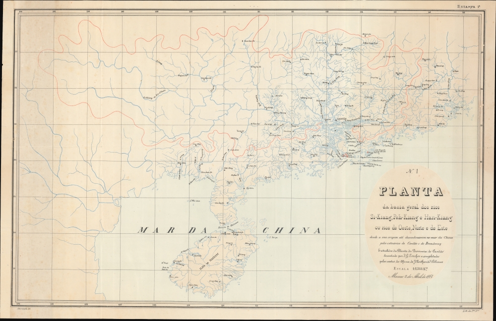
Planta da bacia geral dos rios Si-Kiang, Peh-Kiang e Han-Kiang ou rios do Oeste, Norte e de Este, desde a sua origem até desenbocarem no mar da China pelos estuários de Cantão e do Broadway.
1884 (dated) 16.5 x 25.5 in (41.91 x 64.77 cm) 1 : 2344000
1884 (dated) 16.5 x 25.5 in (41.91 x 64.77 cm) 1 : 2344000
Description
This is a remarkable 1884 Portuguese-language Adolfo Ferreira Loureiro map of Guangdong Province (广东; Canton), China, including Hong Kong, Macao, Guangzhou, and the Pearl River Estuary. The map was designed by Loureiro to assist in his engineering commission to control silt build-up in Macao Harbor. It thus focuses on the vast watershed that drains into the Pearl River, and is, as such, among the earliest works to address the complex river system.
This map is based somewhat on the scarce Jakob Gottlob Lörcher map of Canton, published in Switzerland in 1879, but offers broader coverage and a more specific focus on the watershed of the Pearl River Estuary. The title also attributes work on refining the map to 'J. Perthes' - this can only be the geographer Justus Perthes of Gotha, and one, 'Williams', who we cannot isolate.
A Closer Look
The map covers the China coast from Hainan (海南省) to Shantou (汕头市), and, although it is unnamed, reaches west nearly to Kunming (昆明市). As, the title suggests, the map is intended to detail the Pearl River (珠江) watershed, including its three primary tributaries the (Si-Kiang; 西江) Xijiang, (Peh-Kaing; 北江) Bei, and (Han-Kiang; 东江) Dong Rivers. The vast range of these systems is detailed, with important cities named. The full watershed is outlined in red.This map is based somewhat on the scarce Jakob Gottlob Lörcher map of Canton, published in Switzerland in 1879, but offers broader coverage and a more specific focus on the watershed of the Pearl River Estuary. The title also attributes work on refining the map to 'J. Perthes' - this can only be the geographer Justus Perthes of Gotha, and one, 'Williams', who we cannot isolate.
Publication History and Census
This map is widely attributed Adolfo Ferreira Loureiro, a Portuguese civil engineer active in Macao in the 1880s. It was published by the Imprensa da Universidade de Coimbra and lithographed in two colors by António José Saldanha Assumpção. This is one of only two known examples, the other being held by the Biblioteca Nacional de Portugal.CartographerS
Adolfo Ferreira Loureiro (December 12, 1836 - November 22, 1911) was a Portuguese soldier, engineer, writer, poet, and politician. Loureiro was born in São Bartolomeu, Coimbra, Portugal. He studied mathematics and civil engineering at the University of Coimbra and entered the military in 1858. In 1883, he traveled to British India, Ceylon, Singapore, China, and Macau. In Macao, he accepted a commission as Captain of Engineering and Major of the General Staff, working on desilting the port of Macao. At the same time, he became involved in politics and was elected in 1890 as 'Deputado' to the 1.° Círculo Eleitoral de Macau. A prolific writer, he penned more than 24 works, but is best known for his travel narrative, De Nápoles à China (diário de viagem) (Lisboa: Imprensa Nacional, 1896). Loureiro returned to Portugal where he had a distinguished engineering and academic career. He even curated and built an extensive historical collection of arms and armaments, which were donated to a museum. He was vice-president of the Lisbon Geographic Society, and was also president of the Geodesy section. He was president of the Almeida Garrett Literary Society. Member of the Academia de Ciencias de Portugal. More by this mapmaker...
António José Saldanha Assumpção (1850 - 1900) was a Portuguese lithographer active the late 19th century. His birth and death dates are those given by the Biblioteca Nacional de Portugal, but we can find little confirmation or other information about this printer. He published several well-made chromolithograph maps of Portuguese colonies in Africa and Asia. Learn More...
Imprensa da Universidade de Coimbra (1537 - Present) is a Portuguese academic publisher associated with the University of Coimbra. Founded in 1537, just seven years after the introduction of the printing press into Portugal, it is one of the longest continuously running publishing concerns in the world. Printers where granted academic status as 'professors' and the Imprensa was required to provide two copies of all books printed to the University Library. In addition to official and university publications, as the only press in Coimbra, the Imprensa also took private contract work. It remains an active part of the Universidade de Coimbra. Learn More...
Condition
Very good. Some discoloration along left side. A few pinholes patched on verso. Left margin extended.
References
Biblioteca Nacional de Portugal, C.C. 697 A.