1960 Admiralty Chart of the Eastern Portion of Hong Kong
HongKongWatersEast-admiralty-1960$1,200.00


Title
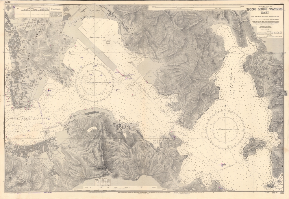
China - South Coast, Hong Kong Waters East, from the Latest Admiralty Surveys to 1959.
1960 (dated) 28 x 40.5 in (71.12 x 102.87 cm) 1 : 12150
1960 (dated) 28 x 40.5 in (71.12 x 102.87 cm) 1 : 12150
Description
An impressive nautical map of the waters between Hong Kong Island and Kowloon, produced in 1960 by the British Admiralty's Hydrographic Office, with minor corrections in handwriting to 1963. It reflects a city in transition, moving beyond its past as a colonial trade entrepôt dominated by wharves and warehouses and instead becoming a proper city in its own right (Hong Kong's population more than tripled between 1930 and 1960, in large part due to refugees fleeing warfare and revolution in mainland China).
The landward features highlight the city's changes and continuities over time. In addition to the aforementioned Tseung Kwan O New Town (which absorbed Futau Chau or Fat Tong Chau Island at right), a number of other large-scale land reclamation projects were undertaken in the years just preceding and postdating this chart. For instance, the open area to the north of the Royal Naval Recreation Grounds, at center towards bottom-left, was formerly a typhoon shelter that had been reclaimed; in 1957, it opened as Victoria Park.
The densely populated neighborhoods of Tsim Sha Tsui and Mong Kok in Kowloon, and Central and Wan Chai (then known as Victoria) on Hong Kong Island, are immediately recognizable. Landmarks are noted, some of them as 'conspicuous' for navigational purposes, including the Kowloon-Canton Railway Tower and the Hong Kong Observatory. Prominent at top towards left is Kai Tak Airport, Hong Kong's main international airport until 1998, famous for its harrowing approaches which skirted mountains and high-rise apartment blocks of Kowloon, including 'Old City Kowloon' or the Kowloon Walled City just to the west.
A Closer Look
Coverage stretches from the southern portion of the Kowloon Peninsula and the Central neighborhood of Hong Kong Island eastwards to what is now the Tseung Kwan O (here as 'Cheung Kwan O or Junk Bay') New Town, constructed on reclaimed land in the 1980s. A wealth of nautical information is marked, including soundings, detailed compasses with magnetic variations, lights, hazards, shoals, buoys, currents, and more. Handwritten annotations provide information updated since the latest printing of the chart in 1960, including an area of forbidden anchorage in Victoria Harbor.The landward features highlight the city's changes and continuities over time. In addition to the aforementioned Tseung Kwan O New Town (which absorbed Futau Chau or Fat Tong Chau Island at right), a number of other large-scale land reclamation projects were undertaken in the years just preceding and postdating this chart. For instance, the open area to the north of the Royal Naval Recreation Grounds, at center towards bottom-left, was formerly a typhoon shelter that had been reclaimed; in 1957, it opened as Victoria Park.
The densely populated neighborhoods of Tsim Sha Tsui and Mong Kok in Kowloon, and Central and Wan Chai (then known as Victoria) on Hong Kong Island, are immediately recognizable. Landmarks are noted, some of them as 'conspicuous' for navigational purposes, including the Kowloon-Canton Railway Tower and the Hong Kong Observatory. Prominent at top towards left is Kai Tak Airport, Hong Kong's main international airport until 1998, famous for its harrowing approaches which skirted mountains and high-rise apartment blocks of Kowloon, including 'Old City Kowloon' or the Kowloon Walled City just to the west.
Publication History and Census
This chart was initially published by the Admiralty in 1903 and updated regularly thereafter, with new editions appearing to 1949, major corrections to 1960, and minor corrections (handwritten) to 1963. The 1960 printing of the chart is only known to be held by the Chinese University of Hong Kong, while the National Library of Australia holds a 1952 printing (lacking the runway built into Kowloon Bay, operational from 1958).Cartographer
The British Admiralty Office (1795 - Present) or the United Kingdom Hydrographic Office refers to the Branch of the English government that is responsible for the command of the British Navy. In 1795 King George III created the United Kingdom Hydrographic Office, known in short as the U.K.H.O., to provide top notch nautical charts to the vast Royal Navy. Prior the founding of the Admiralty the surveying and creation of nautical charts was primarily a commercial venture wherein the cartographer himself, more of than not, actually financed the printing of his own material. The great navigator Cook himself is known to have scrambled for funds to publish his own seminal charts - the most important and advanced of the period. The system of privately funded nautical mapping and publishing left vast portions of the world uncharted and many excellent charts unpublished. King George III, responding significant loss in trade revenue related to shipwrecks and delay due to poor charts, recognized the need for an institutionalized government sponsored cartographic agency - the Admiralty. The first head of the Admiralty, a position known as Hydrographer, was the important cartographer Alexander Dalrymple. Dalrymple started by organizing and cataloging obtainable charts before initiating the laborious process of updating them and filling in the blanks. The first official Admiralty Chart appeared in 1800 and detailed Quiberon Bay in Brittany. By 1808 the position of Hydrographer fell to Captain Thomas Hurd. Hurd advocated the sale of Admiralty charts to the general public and, by the time he retired in 1829, had issued and published some 736 charts. Stewardship of the organization then passed to Rear Admiral Sir Francis Beaufort. It was under Beaufort's administration that the Admiralty truly developed as a "chart making" as opposed to a "chart cataloging" institution. Beaufort held his post from 1829 to 1854. In his 25 years at the Admiralty Beaufort created nearly 1500 new charts and sponsored countless surveying and scientific expeditions - including the 1831 to 1836 voyage of the H.M.S. Beagle. By 1855 the Admiralty's chart catalog listed some 1,981 charts. More by this mapmaker...
Condition
Very good. Wear at bottom-left corner in margin.
References
OCLC 176920911.