This item has been sold, but you can get on the Waitlist to be notified if another example becomes available, or purchase a digital scan.
1850 Walker Map of the Hooghly River Delta, India
HooglyRiver-walker-1850$250.00

Title
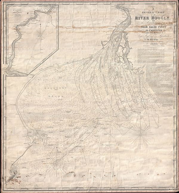
A General Chart of the River Hoogly and the Approaches to it from False Point to Calcutta, Compiled from the Surveys of Captn. Lloyd, and his Assistants, by John Walker.
1850 (dated) 33.5 x 30.5 in (85.09 x 77.47 cm) 1 : 282000
1850 (dated) 33.5 x 30.5 in (85.09 x 77.47 cm) 1 : 282000
Description
A scarce 1850 blueback nautical chart of the Hooghly River, West Bengal, India by John Walker. The chart covers the mouth of The Hooghly and the Bay of Bengal as far a south as False Point. An inset in the upper left quadrant continues to follow the course of the Hooghly as far north as Calcutta (Kolkata). The chart offers countless depth sounds, sailing instructions, and notes on offshore dangers, shoals, and other practical information for the mariner. The Hooghly us a navigable distributary of the Ganges River. The river was an important trade artery in the colonial period and was partially responsible for the British establishing themselves at Calcutta. This chart is extremely scarce and we have identified no other examples offered in recent history.
Cartographer
John Walker (1787 - April 19, 1873) was a British map seller, engraver, lithographer, hydrographer, geographer, draughtsman, and publisher active in London during the 19th century. Walker published both nautical charts and geographical maps. His nautical work is particularly distinguished as he was an official hydrographer for the British East India Company, a position, incidentally, also held by his father of the same name. Walker's maps, mostly published after 1827, were primarily produced with his brothers Charles Walker and Alexander Walker under the imprint J. and C. Walker. Among their joint projects are more than 200 maps for the influential Society for the Diffusion of Useful Knowledge Atlas (SDUK). In addition they published numerous charts for James Horsburgh and the British Admiralty Hydrographic Office, including Belcher's important map of Hong Kong and Carless' exploratory map of Karachi. The J. and C. Walker firm continued to publish after both Walkers died in the 1870s. More by this mapmaker...
Condition
Average. Chart has some creasing and staining at top. Linen backing and edging intact but exhibit wear. A good candidate for restoration work.