This item has been sold, but you can get on the Waitlist to be notified if another example becomes available, or purchase a digital scan.
1888 Wellge Bird's-Eye View Map of Hot Springs, Arkansas
HotSpringsArkansas-wellge-1888$2,000.00

Title
Hot Springs, Ark.
1888 (undated) 16.25 x 27 in (41.275 x 68.58 cm)
1888 (undated) 16.25 x 27 in (41.275 x 68.58 cm)
Description
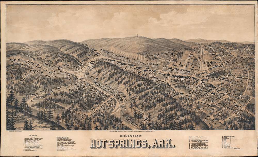
An exceptionally rare 1888 two-color chromolithograph bird's-eye view map of Hot Springs, Arkansas - arguably American's first national park and spa city. The view looks east on Hot Springs, possibly from a high point on nearby Sugarloaf Mountain - now part of Hot Springs National Park. Central Avenue, with its bath houses and grand hotels, cuts laterally across the page. Eleven bath houses are noted and keyed alphabetically in the lower right - curiously, they are lettered A-M, but 'I' and 'J' have been omitted. In addition, some 33 other locations, ranging from hotels to stationers and jewelers, are noted and keyed numerically. In the background, the wooden observation tower built in 1877 on top of Hot Springs Mountain by local mill owner Enoch Woolman is identifiable - this was replaced by the current metal tower in 1906.
City views were being produced in the United States as early as the 1830s, but the genre exploded after the American Civil War (1861 - 1865). Bridging the gap between maps and pictures, most 19th century American bird's-eye views presented cities to the public from high vantage points. Some were imagined, but others were drawn from hot-air balloons or nearby hills. The presentation, combining high elevation, commercial interest, and new printing technology, created a uniquely American art form, as described by historian Donald Karshan,
America's First Resort
Hot Springs, Arkansas is one of America's first resort cities. As one might guess, the city gets its names from mineral thermal springs that produce nearly one million gallons of c. 143°F water per day. The area was sacred to First Nations people who called it the 'Valley of the Vapors' and regarded as a neutral ground where even warring tribes could visit for healing. The conquistador Hernando de Soto visited the springs in 1541, claiming them in the name of Spain. In 1832, Andrew Jackson named Hot Springs the first 'Federal Reservation', essentially a national park, but predating the official creation of the national park system by nearly 40 years. By the late 19th century, Hot Springs transformed into an elegant resort city, with grand hotels, spacious bath houses, and fine restaurants - as seen here. On a darker note, during Prohibition, it became a haven for moneyed mobsters, who enjoyed the city's creature comforts and isolation. Al Capone, Frank Costello, Bugs Moran, and Lucky Luciano are just a few of the infamous criminals who regularly visited. Today, Hot Springs has been fully folded into the National Park System.American Bird's-Eye City Views
The tradition of the bird's-eye city view emerged in the United States in the middle part of the 19th century and coincided with the commercial development of lithographic printing. While before the rise of lithography, the ability to own and display artwork in the home was largely limited to the extremely wealthy, lithographic printing made it possible for everyone to own visually striking artwork. A robust trade developed in portraits of political leaders, allegorical and religious images, and city views.City views were being produced in the United States as early as the 1830s, but the genre exploded after the American Civil War (1861 - 1865). Bridging the gap between maps and pictures, most 19th century American bird's-eye views presented cities to the public from high vantage points. Some were imagined, but others were drawn from hot-air balloons or nearby hills. The presentation, combining high elevation, commercial interest, and new printing technology, created a uniquely American art form, as described by historian Donald Karshan,
Some print connoisseurs believe that it was only with the advent of the full-blown city-view lithograph that American printmaking reached its first plateau of originality, making a historical contribution to the graphic arts. They cite the differences between the European city-view prints and the expansive American version that reflects a new land and a new attitude toward the land.The vogue for bird's-eye city views lasted from about 1845 to 1920, during which period some 2,400 cities were thus portrayed, some multiple times. Although views were produced in many urban centers, the nexus of view production in the United States was Milwaukee, Wisconsin. The major American viewmakers were Stoner, Wellge, Bailey, Fowler, Hill, Ruger, Koch, Burleigh, Norris, and Morse, among others.
Chromolithography
Chromolithography is a color lithographic technique developed in the mid-19th century. The process involved using multiple lithographic stones, one for each color, to yield a rich composite effect. Oftentimes, the process would start with a black basecoat upon which subsequent colors were layered. Some chromolithographs used 30 or more separate lithographic stones to achieve the desired product. Chromolithograph color could also be effectively blended for even more dramatic results. The process became extremely popular in the late 19th and early 20th centuries, when it emerged as the dominate method of color printing. The vivid color chromolithography produced made it exceptionally effective for advertising and propaganda imagery.Publication History and Census
This view was drawn by Henry Wellge and lithographed in Milwaukee, Wisconsin, by Beck and Pauli. The view is exceedingly rare. We note one example at the Library of Congress. Reps notes a second example at the Amon Carter Museum of Western Art in Fort Worth, Texas. According to Reps, this is one of just 4 known bird's-eye views of anywhere in Arkansas, the others representing Little Rock (1871 and 1887) and Texarkana (1888).CartographerS
Henry Wellge (1850 – 1923) was an American panoramic bird's-eye view publisher, artist, and cartographer active in Milwaukee in the late 19th and early 20th century. Wellge was born in Germany in 1850. His first view, in 1878, was of Chilton Wisconsin, but most of his early work is in association with J. J. Stoner, another prolific view maker. Eventually established his own firm Henry Wellge and Company. Later his published and Norris, Wellge and Company. Ultimately though, most of his work appears under the imprint of the American Publishing Company. He continued to publish views until about 1910 with about 152 views bearing his imprint. Wellge is known for large dramatic views illustrated with emphasis on the horizontal dimension. More by this mapmaker...
Beck and Pauli (fl. c. 1878 – 1889) was a Milwaukee, Wisconsin based lithography firm founded in 1878 by Clemens J. Pauli and Adam Beck. The firm published hundreds of lithograph city views for many of the most prominent viewmakers of the period, including Lucien Rinaldo Burleigh, J. J. Stoner, Henry Wellge, Pauli himself, and others. The company was most active in the mid-1880 until about 1889, when the partners went separate ways and closed the company. Learn More...
Condition
Good. Exhibits older but excellent restoration on verso, including corner repairs and remargining. Warm even toning.
References
Reps, John, Views and Viewmakers of Urban America (University of Missouri, Columbia, 1984), #24. Library of Congress, G4004.H6A3 1888 .W4.