This item has been sold, but you can get on the Waitlist to be notified if another example becomes available, or purchase a digital scan.
1855 Beckwith Railroad Survey of Humboldt Mountains and the Mud Lakes, Nevada
HumboldtMountainstoMudLakes-beckwith-1855$125.00

Title
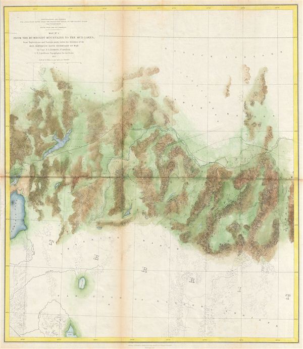
Map No. 3 From the Humboldt Mountains to the Mud Lakes, from Explorations and Surveys made under the direction of the Hon. Jefferson Davis Secretary of War by Capt. E. G. Beckwith 3rd Artillery F. W. Egloffstein Topographer for the Route 1855.
1855 (dated) 18.5 x 21 in (46.99 x 53.34 cm)
1855 (dated) 18.5 x 21 in (46.99 x 53.34 cm)
Description
This is a rare and important 1855 map of parts of Nevada prepared for the Pacific Railroad Survey. This map covers from the Humboldt Mountains (West Humboldt Range), at the western end of the Great Basin, westward was far as Pyramid Lake and the Mud Lakes. Offers superb topographical detail – most attributable to the expedition topographer F. W. egloffstein. This is the third of a series of four maps drawn and surveyed By Captain e. G. Beckwith with the intention of determining the best route for a railroad from the Mississippi to the Pacific. The route suggested here follows the Humboldt River through the West Humboldt Range before turning southwest to pass between Mud Lake and Mud Lake Peak. Prepared under the direction of Secretary of War Jefferson Davis (future president of the Confederacy) by Captain e. G. Beckwtih and F. W. egloffstein. engraved by Selmar Siebert in Washington D.C.
Cartographer
The Pacific Railroad Surveys (1853 - 1855) were established in 1853 with the goal of identifying the best possible routes for a transcontinental railroad from the Mississippi to the Pacific. The need for transcontinental railroad made itself evident shortly after the California Gold rush when the westward expansion was at its heights. The federal government, acting under the Sectary of War, Jefferson Davis (of Civil War fame), initiated a series of expeditions of the western territories. These expeditions included surveyors, cartographers, artists, zoologists, botanists and geographers. The resultant work, a 12 volume compendium entitled Reports of Explorations and Surveys, to ascertain the most practicable and economical route for a railroad from the Mississippi River to the Pacific Ocean eventually led to the constructions of several different transcontinental railroads. More by this mapmaker...
Source
Reports of Explorations and Surveys, to Ascertain the Most Practicable and Economical Route for a Railroad From the Mississippi River to the Pacific Ocean. Made Under the Direction of the Secretary of War, In 1853-56, According to Acts of Congress of March 3, 1853, May 31, 1854, and August 5, 1854. Volume XI. Washington: George W. Bowman, Printer. 1861. 36th Congress, 2d Session, Senate, Ex. Doc. (Washington) 1855.
Condition
Very good. Some light spotting and toning on original fold lines. Else clean. Backed with archival tissue.
References
Rumsey 0693.030. Wheat, C., The Mapping of the Transmississippi West, 1540-1861, #825.