This item has been sold, but you can get on the Waitlist to be notified if another example becomes available, or purchase a digital scan.
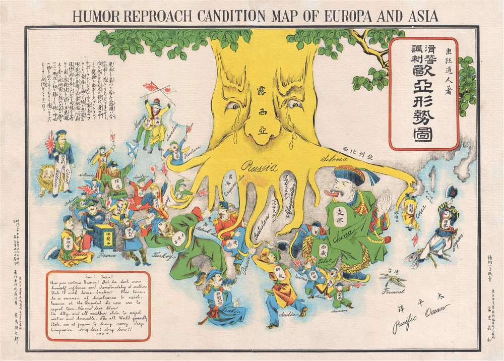
1904 Japanese Serio-Comic Map of Asia and Europe (Russo-Japanese War)
HumorReproachCandition2-japanese-1904$3,750.00

Title
Humor Reproach Candition Map of Europa and Asia. / 滑稽諷刺歐亞形勢圖
1904 (dated) 15 x 21 in (38.1 x 53.34 cm)
1904 (dated) 15 x 21 in (38.1 x 53.34 cm)
Description
A previously unknown Meiji 37 or 1904 Japanese broadsheet serio-comic map relating to the Russo-Japanese War. This map was issued in May 28 of 1904, immediately following Japan's successful siege and bombardment Russian held Port Arthur (Dalian). Of the four Japanese serio-comic maps associated with the Russo-Japanese war, this is the second, predated only by Kisaburō Ohara's April 1904 A Humorous Diplomatic Atlas of Europe and Asia.
Understanding the Map
Unlike Ohara's map, which was issued one month earlier during the Siege of Port Arthur, this map postdates the siege by nearly a month. Here the Russian Octopus has been replaced by a gigantic yellow weeping tree with tentacle-like roots extending into Europe and Asia. Japan, from its island stronghold, hacks at Russia with a mighty axe, chopping at its roots and yielding serious damage in the vicinity of Port Arthur. Throughout Europe and Asia Japanese flags and Japanese's Imperial Naval ensigns are being waved in celebration of the Japanese victory. The exceptions are Germany, which as a Russian ally is waving the Russian Naval ensign, and Denmark, which waves a Swiss flag indicating neutrality. China claps its hands and childishly sticks out its tongue in the direction of Russia.Japan's Message to the West
While the presence of a large English text block in the lower left suggests this map was intended for both European, specifically English, and Japanese audiences, it is so poorly written that we can safely assume the map never developed a following in Europe. Although difficult to interpret, the text reads as follows,See! See!Our interpretation is that the author wants to suggest that Russia, having been defeated by Japan, is suffering an existential crisis. This was indeed the first time in modern history that a European power suffered a major defeat at the hands of an East Asian power. The victory over Russia at Port Arthur cemented Japan's position as a world power and forced European powers to reevaluate their own position in the world. The defeat also cost Russia the respect of its allies and subject states, potentially inspiring others to stand against the giant.
How poor riotous Russian! Bat he dont now himself influence and disordinately at another state to work house-breaker. This time he is occasion of hopelessness to exist. Because, at the Oriental he now are to repeat tear-war and tear war. He ally and all another stete to reject riotias and accusable. The all world generally state are at Japan to bring mercy deep compassion. Long Live! Long Live!!
Japanese Serio Comic Maps of the Russo-Japanese War
Although Serio-Comic maps were common in Europe from at least the 1860s, they were first discovered by Japanese artists and printers during the Russo-Japanese War, when they became popular tools for both internal propaganda and communicating Japanese solidarity with European powers, specifically England. Five Japanese Serio-Comic maps were issued to illustrate the Russo-Japanese War at different points. They are issued by different artists and publishers, but appear sequentially, by month, suggesting central planning - possibly the Tomizu Group or Anti-Russian Society (対露同志会). All are rare, but the first map in the series, by Kisaburō Ohara and Shingo Nakamura, is the most common. The others are exceedingly scarce. We offer a breakdown of known maps from this series,- April 1904 - Kisaburō Ohara / 小原喜三郎 - A Humorous Diplomatic Atlas of Europe and Asia / 滑稽欧亜外交地圖.
- May 3, 1904 - Nakayama Kyūshirō / 中山久四郎 - New Commemorative Print of Various Countries Sympathies in the Russo Japanese War. / 崭新纪念画 日露戰爭列國义同情.
- May 1904 - Unknown - Humor Reproach Candition Map of Europe and Asia. / 滑稽諷刺歐亞形勢圖
- June 1904 - Kamijo Yomotaro - New Comical Atlas / 滑稽万国形勢新地圖.
- July 1904 - Haru EiDō / 春榮堂- New Funny Map of Europe and Asia / 亞細亞歐羅巴嶄新滑稽地圖.
Publication History and Census
The map was printed on May 24th, 1904, and distributed on May 28th. This map is exceedingly rare. There are no other known examples of this map. Owned jointly with Boston Rare Maps.Condition
Very good. Professional restoration at fold intersection. Blank on verso.