
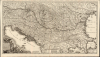
1700 / 1719 Joachim Ottens Map of Hungary and the Danube


This item has been sold.
Novissima tabula regni Hungariae et regionum quondam ei unitarum ut Transilvaniae, Valachiae, Moldaviae, Serviae, Romaniae, Bulgariae, Bessarabiae, Croatiae, Bosniae, Dalmatiae, Slavoniae, Morlachiae et reipublicae Ragusanae...
Centuries of War.
- Digital Map Information
- Suitable for large format printing
- File Size: 44.02 MB
- File Type: ZIP / TIFF
- ICC color profile embedded
- Delivered instantly via download link
Centuries of War.
Joachim Ottens' rare, large, and beautifully engraved c. 1700 map of the lands about the Danube captures the region in the wake of the 1699 Treaty of Karlowitz, which brought the Great Turkish War (1683 - 1699) to a close. Ottens' map encompasses the theatre of that war and records key battles in that region, stretching back to the 14th century.A Closer Look
Tracing the course of the Danube, the map depicts Austria, Transylvania, Sclavonia, Croatia, Bosnia, Serbia, and Dalmatia. Portions of Austria, Greece, and Italy appear as well. Vienna, Buda and Pest, Belgrade, and Constantinople are among the major cities appearing here. A legend at the bottom center enumerates the map's symbols, indicating cities and towns of varying sizes, bishoprics and archbishoprics, universities, lighthouses, defenses, castles, and battle sites.Of these latter, there are many. Although the Great Turkish War had spanned just over 30 years, Ottens' map marks a much broader span of conflict, including an abundance of battles from the 15th century and the first major battle against the Ottoman Empire, the 1396 Battle of Nicopolis (a resounding defeat for the Christians). The map presents a convoluted history. For example, the Serbian city of Niš (Nissa on the map) has marked the dates of its 1366 absorption by the Ottomans, its 1689 capture by the Austrian army, and its recapture by the Ottomans the following year.
A Triumphal Cartouche
The main title cartouche at the bottom-left, surmounted by the Hungarian coat of arms, is a celebration of victory in the Great Turkish War. The Holy Roman Emperor, Leopold I (1640 - 1705), stands before the cartouche, directing a band of surrendering Turkish soldiers to kneel as they present their swords. A battle still rages in the background.Publication History and Census
This map was engraved on two plates by Jacob Keyser for inclusion in Joachim Ottens' atlas as early as 1700. We see institutional copies with an additional title, in French, in the upper margin, credibly dated 1700 and 1710. This example (lacking the French title but retaining Joachim Ottens' imprint) corresponds to examples dated 1719. After 1725, Joachim's imprint is replaced with that of his heirs, Josue and Reiner. None of these states is common. Of the 13 separate examples listed in OCLC, only one corresponds to this state. It is scarce on the market.Cartographer
Ottens (fl. c. 1680 - 1785) was a prominent Amsterdam map publishing family active for nearly 100 years. Joachim Ottens (1663 - 1719) was born in Amsterdam to a family of seafarers and educated in Amsterdam's Evangelical Lutheran community. He likely learned copperplate engraving under Frederick de Wit (1629 - 1706), for whom he worked until about 1710. In 1710, he was admitted to the Sint-Lucasgilde (Guild of St. Luke) and, in 1711, Joachim founded his own firm. Although Joachim died only a few years later, in 1719, his widow continued the business, either publishing as either 'I. Ottens', 'Ottens', or 'In de Wereldcaert' [In the World Map]. In 1726, Joachim Otten's sons, Renier (1698 - 1750) and Joshua (1698 - 1750), established a partnership and generally published as 'R. and I. Ottens'. Although they ran separate shops, on Nieuwendijk and Kalverstraat, they worked jointly as a singular business until Renier's death in 1750, at which point Joshua assumed full control. After Joshua's death in 1765, his widow continued the firm with their son, Renier II, changing the imprint to 'Joshua and Reinier Ottens.' Joshua's widow, Johanna de Lindt, held an auction sale of their engraved plates in 1784. Ottens' work stands out in that all of their maps were separate issues, though often found compiled into special, made-to-order multi-volume composite Atlas factice works, such as the Atlas. Some examples of the Atlas include over 800 separately issued maps. Because they were not uniformly issued in standard atlases, Ottens maps are often of the utmost rarity and are notable for their exceptionally rich engraving. Further Details...
Condition
Very good. Some mended splits at folds with no loss to image.
References
OCLC 165836386.