This item has been sold, but you can get on the Waitlist to be notified if another example becomes available, or purchase a digital scan.
1752 Homann Heirs Map of Hungary, the Balkans, & Northern Greece
Hungarie-hmhr-1752$214.50

Title
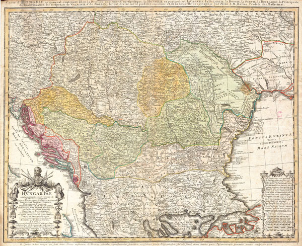
Hvngariae (Huntariae)
1752 18.5 x 23 in (46.99 x 58.42 cm)
1752 18.5 x 23 in (46.99 x 58.42 cm)
Description
A stunning 1752 Homann Heirs hand colored map of Hungary, northern Greece, and the Balkans. Expansive view of the region which covers modern day Hungary, Croatia, Macedonia, Albania, the Slav republics and Romania south to the northern parts of Greece, bounded by the Adriatic and Black Seas. Includes an uncolored decorative title cartouche on the bottom left hand corner of the map.
Cartographer
Homann Heirs (1730 - 1848) were a map publishing house based in Nuremberg, Germany, in the middle to late 18th century. After the great mapmaker Johann Baptist Homann's (1664 - 1724) death, management of the firm passed to his son Johann Christoph Homann (1703 - 1730). J. C. Homann, perhaps realizing that he would not long survive his father, stipulated in his will that the company would be inherited by his two head managers, Johann Georg Ebersberger (1695 - 1760) and Johann Michael Franz (1700 - 1761), and that it would publish only under the name 'Homann Heirs'. This designation, in various forms (Homannsche Heirs, Heritiers de Homann, Lat Homannianos Herod, Homannschen Erben, etc..) appears on maps from about 1731 onwards. The firm continued to publish maps in ever diminishing quantities until the death of its last owner, Christoph Franz Fembo (1781 - 1848). More by this mapmaker...
Condition
Very good condition with light uniform age toning. Narrow upper margin. Blank on verso.