This item has been sold, but you can get on the Waitlist to be notified if another example becomes available, or purchase a digital scan.
1701 Homann Map of Hungary
Hungary-homann-1701$300.00

Title
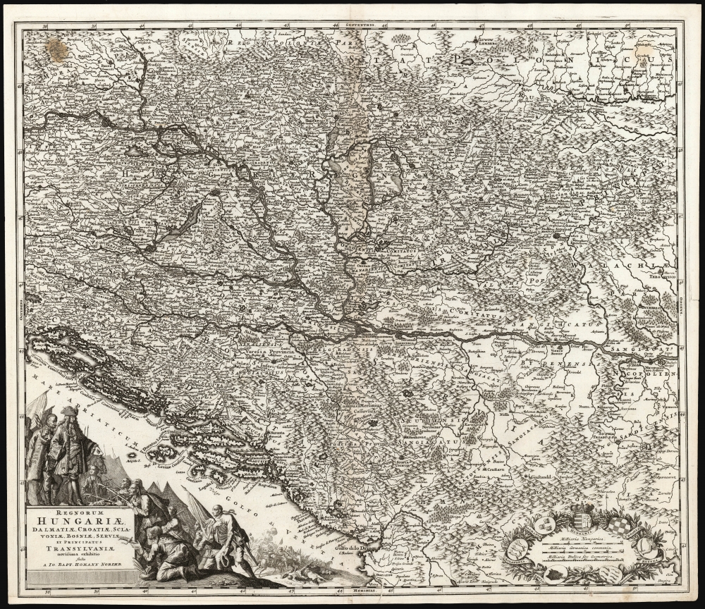
Regnorum Hungariae, Dalmatiae, Croatiae, Sclavoniae, Bosniae, Serviae et Principatus Transylvaniae novissima exhibiteo facta A Io. Bapt. Homann Norimb.
1701 (undated) 19 x 22.25 in (48.26 x 56.515 cm) 1 : 1900000
1701 (undated) 19 x 22.25 in (48.26 x 56.515 cm) 1 : 1900000
Description
This is a first plate, first state example of Johann Baptist Homann's 1701 map of the Kingdoms of Hungary and the Balkans, produced in celebration of the 1699 victory of the Holy League following the Great Turkish War (1683 - 1699), concluded by the Ottoman Empire's surrender at the Treaty of Karlowitz. Consequently, this represented the new frontier with the Ottoman Empire following the treaty, spanning from the border of Poland in the north to Albania in the south.
A Closer Look
The map embraces the course of the Danube from Austria to Nikopol in Bulgaria. The Dalmatian coast of the Gulf of Venice from Croatia to Albania appears in the southwest; The Tsarigrad Road (running from Belgrade to Sofia on this map, and ultimately to Istanbul) is also depicted in the southeast.Triumphal Engraving
The ornate, superbly executed cartouche dramatizes the results of the Great Turkish War. A regal figure - probably the Holy Roman Emperor, Leopold I (1640 - 1705) - stands atop the cartouche, directing a band of surrendering Turkish soldiers to kneel as they present their swords.Publication History and Census
This map's printing history is convoluted. This first plate appeared first as a separate issue in 1701; it was included without change in the 1707 and 1710 editions of Homann's Neuer Atlas. We are aware of a second state of this plate, with a new cartouche, produced after 1710 but before 1716, at which point a second plate based on the revised first was engraved. Johann Christian Homann, J. B. Homan's son, replaced it with a new map after his father's death in 1724.Cartographer
Johann Baptist Homann (March 20, 1664 - July 1, 1724) was the most prominent and prolific map publisher of the 18th century. Homann was born in Oberkammlach, a small town near Kammlach, Bavaria, Germany. As a young man, Homann studied in a Jesuit school and nursed ambitions of becoming a Dominican priest. Nonetheless, he converted to Protestantism in 1687, when he was 23. It is not clear where he mastered engraving, but we believe it may have been in Amsterdam. Homann's earliest work we have identified is about 1689, and already exhibits a high degree of mastery. Around 1691, Homann moved to Nuremberg and registered as a notary. By this time, he was already making maps, and very good ones at that. He produced a map of the environs of Nürnberg in 1691/92, which suggests he was already a master engraver. Around 1693, Homann briefly relocated to Vienna, where he lived and studied printing and copper plate engraving until 1695. Until 1702, he worked in Nuremberg in the map trade under Jacob von Sandrart (1630 - 1708) and then David Funck (1642 - 1709). Afterward, he returned to Nuremberg, where, in 1702, he founded the commercial publishing firm that would bear his name. In the next five years, Homann produced hundreds of maps and developed a distinctive style characterized by heavy, detailed engraving, elaborate allegorical cartouche work, and vivid hand color. Due to the lower cost of printing in Germany, the Homann firm could undercut the dominant French and Dutch publishing houses while matching their diversity and quality. Despite copious output, Homann did not release his first major atlas until the 33-map Neuer Atlas of 1707, followed by a 60-map edition of 1710. By 1715, Homann's rising star caught the attention of the Holy Roman Emperor Charles VI, who appointed him Imperial Cartographer. In the same year, he was also appointed a member of the Royal Academy of Sciences in Berlin. Homann's prestigious title came with several significant advantages, including access to the most up-to-date cartographic information as well as the 'Privilege'. The Privilege was a type of early copyright offered to very few by the Holy Roman Emperor. Though less sophisticated than modern copyright legislation, the Privilege offered limited protection for several years. Most all J. B. Homann maps printed between 1715 and 1730 bear the inscription 'Cum Priviligio' or some variation. Following Homann's death in 1724, the firm's map plates and management passed to his son, Johann Christoph Homann (1703 - 1730). J. C. Homann, perhaps realizing that he would not long survive his father, stipulated in his will that the company would be inherited by his two head managers, Johann Georg Ebersberger (1695 - 1760) and Johann Michael Franz (1700 - 1761), and that it would publish only under the name 'Homann Heirs'. This designation, in various forms (Homannsche Heirs, Heritiers de Homann, Lat Homannianos Herod, Homannschen Erben, etc.) appears on maps from about 1731 onwards. The firm continued to publish maps in ever-diminishing quantities until the death of its last owner, Christoph Franz Fembo (1781 - 1848). More by this mapmaker...
Source
Homann, J. B., Neuer Atlas bestehend in einig curieusen Astronomischen Kuppren und vielen auserlesenen accuratensten Land-Charten über die Gantze Welt, (Nuremberg: Homann), 1707.
Homann's Neuer Atlas bestehend in einig curieusen Astronomischen Kuppren und vielen auserlesenen accuratensten Land-Charten über die Gantze Welt was first publihsed in 1707 with 33 maps. A second edition followed in 1710 with 60 maps. Subsequent editions followed until about 1730. The title page notes proudly that the atlas features measurements based on the 'Copernican principle of the moving sky', a truly state-of-the-art innovation for the period. Regardless of editions, collations of the atlas are inconsistent, with some examples having less, while others have more maps - a consequence of the fact that the map sheets were delivered loose, to be bound at the buyer's discretion, and so some buyers chose to omit maps they did not consider relevant, or add others they did. Between editions, the constituent maps, particularly of European regions, were regularly updated to reflect the most recent political events. The atlas continued to be published by Homann's son, J. C. Homann (1703 - 1730), and then by Homann Heirs. Most examples also feature a fine allegorical frontispiece with the title Atlas Novus Terrarum Orbis Imperia, regna et Status, which was used for multiple Homann atlases, including the Neuer Atlas and the Atlas Minor.
Condition
Good. Printer's crease at bottom; lower margin trimmed with some loss of border at lower left; reinstated. Tallow stain to upper left.
References
OCLC 214288988.