1705 Gerard and Leonard Valk Map of Hungary and the Lower Danube
Hungary-valk-1705$750.00

Title
Hungaria Generalis, divisa in proprie dictam Hungariam, Principatum Transylvaniam, Regiones Dalmatiae, Sclavoniae, Moldaviae, Valachiae, Bulgariae, Croatiae, Bosniae, Serviae, Romaniae et Bessarabiae.
1705 (undated) 19.5 x 23.5 in (49.53 x 59.69 cm) 1 : 2300000
1705 (undated) 19.5 x 23.5 in (49.53 x 59.69 cm) 1 : 2300000
Description
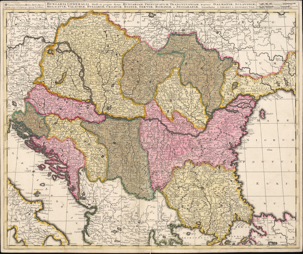
This is a beautiful, contemporary-color example of Gerard and Leonard Valk's c. 1705 map of the lands surrounding the course of the Danube, extending from Vienna to the Black Sea. The map encompasses the perennial seat of war between Christian European powers and the Turkish Empire.
One territory not ceded to the Habsburgs was the Banat of Timisoara: a roughly rectangular piece of land at the center of this map, roughly cornered by Belgrade, Cenad, and Orsov, now occupied mainly by Romania. In earlier maps, this region was not assigned to Hungary; many maps of Hungary did not reach further east than the vicinity of Belgrade. During the war, much of the territory of the Banat fell under the military control of Habsburg forces led by celebrity general Eugene of Savoy, despite Timisoara itself remaining in Ottoman hands. Under the Treaty of Karlowitz, the Banat passed back to the Ottoman Empire, as part of Bulgaria.
In spite of this, the map unambiguously depicts this territory as part of Hungary - not only in terms of the color applied to the map, but also of the engraved borders. Valk's map was not alone in this: contemporary works by Schenk and others also presented the Banat as Hungarian territory. This reflected a situation not in place until the Austro-Turkish War (1716 - 1718), in which Eugene of Savoy reconquered it.
A full census of maps of this region produced before, during, and in the wake of the Great Turkish War might illuminate the source of this apparent discrepancy, and indicate whether the cartographic representation of the Banat as a Hungarian territory ignored the Treaty of Karlowitz inadvertently, or deliberately as a propagandistic statement of Habsburg power.
A Closer Look
Tracing the course of the Danube, the map covers Austria, Hungary, Transylvania, Sclavonia, Croatia, Bosnia, Serbia, and Dalmatia. Portions of Romania, Greece, and Italy appear as well. Vienna, Buda and Pest, Belgrade, and Constantinople are among the major cities appearing here. The map's rich original color distinguishes key principalities.The Banat of Timisoara
This map was produced in the years after the Great Turkish War (1683 - 1699), which ended with the Treaty of Karlowitz (1699). It presents the frontier between Christian Europe and the Ottoman Empire. Following the treaty, Transylvania, Serbia, Bosnia, Croatia, and Slavonia had all passed from the Ottoman Empire to Habsburg Austria.One territory not ceded to the Habsburgs was the Banat of Timisoara: a roughly rectangular piece of land at the center of this map, roughly cornered by Belgrade, Cenad, and Orsov, now occupied mainly by Romania. In earlier maps, this region was not assigned to Hungary; many maps of Hungary did not reach further east than the vicinity of Belgrade. During the war, much of the territory of the Banat fell under the military control of Habsburg forces led by celebrity general Eugene of Savoy, despite Timisoara itself remaining in Ottoman hands. Under the Treaty of Karlowitz, the Banat passed back to the Ottoman Empire, as part of Bulgaria.
In spite of this, the map unambiguously depicts this territory as part of Hungary - not only in terms of the color applied to the map, but also of the engraved borders. Valk's map was not alone in this: contemporary works by Schenk and others also presented the Banat as Hungarian territory. This reflected a situation not in place until the Austro-Turkish War (1716 - 1718), in which Eugene of Savoy reconquered it.
A full census of maps of this region produced before, during, and in the wake of the Great Turkish War might illuminate the source of this apparent discrepancy, and indicate whether the cartographic representation of the Banat as a Hungarian territory ignored the Treaty of Karlowitz inadvertently, or deliberately as a propagandistic statement of Habsburg power.
Improved Eastern Geography
The dominant maps of the mid-17th century, such as the 1677 Visscher, grew increasingly vague the further east one looked. The Ottoman regions north of the Danube presented here are much more sharply detailed than maps just 30 years prior. The chronology of the mapping of Wallachia, Moldova, and Bessarabia would reward scrutiny.Publication History and Census
This map was engraved for publication by Gerard and Leonard Valk I as early as 1705. We see copies cataloged only by the universities of Utrecht and Bern. It does appear on the market from time to time.Cartographer
Gerard Valk (September 30, 1652 - October 21, 1726) (aka. Valck, Walck, Valcke), was a Dutch engraver, globe maker, and map publisher active in Amsterdam in the latter half of the 17th century and early 18th century. Valk was born in Amsterdam where his father, Leendert Gerritsz, was a silversmith. He studied mathematics, navigation, and cartography under Pieter Maasz Smit. Valk and moved to London in 1673, where he studied engraving under Abraham Blooteling (or Bloteling) (1634 - 1690), whose sister he married, and later worked for the map sellers Christopher Browne and David Loggan. Valke and Blooteling returned to Amsterdam in 1680 and applied for a 15-year privilege, a kind of early copyright, from the States General, which was granted in 1684. In 1687, he established his own firm in Amsterdam in partnership with Petrus (Pieter) Schenk, who had just married his sister, Agata. They published under the imprint of Valk and Schenk. Also, curiously in the same year Valk acquired the home of Jochem Bormeester, also engraver and son-in-law of art dealer Clement De Jonghe. Initially Valk and Schenk focused on maps and atlases, acquiring the map plates of Jodocus Hondius and Jan Jansson in 1694. Later, in 1701 they moved into the former Hendrick Hondius (the younger) offices where they began producing globes. Valk and Schenk soon acquired the reputation of producing the finest globes in the Netherlands, a business on which they held a near monopoly for nearly 50 years. In 1702, Valk joined the Bookseller's Guild of which he was promptly elected head. Around the same time, Gerard introduced his son, Leonard, who was married to Maria Schenk, to the business. Leonard spearheaded the acquisition of the map plates of Frederick de Wit in 1709. Nonetheless, Leonard was nowhere near as sophisticated a cartographer or businessman as his father and ultimately, through neglect, lost much the firm's prestige. After his death, the firm was taken over by his widow Maria. More by this mapmaker...
Condition
Very good. Some wormholes with minimal loss.
References
OCLC 902602371.