This item has been sold, but you can get on the Waitlist to be notified if another example becomes available, or purchase a digital scan.
1906 U.S. Coast Survey Map of Hyannis Harbor (Hyannisport), Cape Cod
HyannisHarbor-uscs-1906$325.00

Title
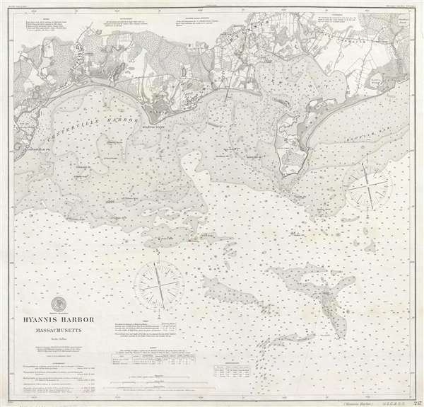
Hyannis Harbor Massachusetts.
1906 (dated) 26.6 x 27 in (67.564 x 68.58 cm) 1 : 20000
1906 (dated) 26.6 x 27 in (67.564 x 68.58 cm) 1 : 20000
Description
A very attractive 1906 separate issue U. S. Coast and Geodetic Survey nautical chart of coastal map of Hyannis Harbor. Centered on Hyannis Point, the map covers from Osterville to Parker's River, including Lewis Bay, Point Gammon, Hyannisport, Craigsville, Hyannis, West Yarmouth, Centerville, and Centerville Harbor. The map extends north roughly as far as modern-day Route 28, which than, as now, was modern day Yarmouth Main Street. There is a high level of inland detail, with topography, individual buildings, streets, and property lots noted. Nautically the map employs depth soundings and stippled shading to convey sea depth. Red beacons indicate light buoys.
This map was initially published in 1894. The present example exhibits updates through 1905. The original surveys for the amp were completed between 1845 and 1888. The topography was completed roughly around the same time, between 1849 and 1890. Magnetic observations were completed in 1845 and 1846, an updated in 1905 and 1906. Published under W. W. Duffield, Superintendent of the Survey.
This map was initially published in 1894. The present example exhibits updates through 1905. The original surveys for the amp were completed between 1845 and 1888. The topography was completed roughly around the same time, between 1849 and 1890. Magnetic observations were completed in 1845 and 1846, an updated in 1905 and 1906. Published under W. W. Duffield, Superintendent of the Survey.
Cartographer
The Office of the Coast Survey (1807 - present) founded in 1807 by President Thomas Jefferson and Secretary of Commerce Albert Gallatin, is the oldest scientific organization in the U.S. Federal Government. Jefferson created the "Survey of the Coast," as it was then called, in response to a need for accurate navigational charts of the new nation's coasts and harbors. The spirit of the Coast Survey was defined by its first two superintendents. The first superintendent of the Coast Survey was Swiss immigrant and West Point mathematics professor Ferdinand Hassler. Under the direction of Hassler, from 1816 to 1843, the ideological and scientific foundations for the Coast Survey were established. These included using the most advanced techniques and most sophisticated equipment as well as an unstinting attention to detail. Hassler devised a labor intensive triangulation system whereby the entire coast was divided into a series of enormous triangles. These were in turn subdivided into smaller triangulation units that were then individually surveyed. Employing this exacting technique on such a massive scale had never before been attempted. Consequently, Hassler and the Coast Survey under him developed a reputation for uncompromising dedication to the principles of accuracy and excellence. Unfortunately, despite being a masterful surveyor, Hassler was abrasive and politically unpopular, twice losing congressional funding for the Coast Survey. Nonetheless, Hassler led the Coast Survey until his death in 1843, at which time Alexander Dallas Bache, a great-grandson of Benjamin Franklin, took the helm. Bache was fully dedicated to the principles established by Hassler, but proved more politically astute and successfully lobbied Congress to liberally fund the endeavor. Under the leadership of A. D. Bache, the Coast Survey completed its most important work. Moreover, during his long tenure with the Coast Survey, from 1843 to 1865, Bache was a steadfast advocate of American science and navigation and in fact founded the American Academy of Sciences. Bache was succeeded by Benjamin Pierce who ran the Survey from 1867 to 1874. Pierce was in turn succeeded by Carlile Pollock Patterson who was Superintendent from 1874 to 1881. In 1878, under Patterson's superintendence, the U.S. Coast Survey was reorganized as the U.S. Coast and Geodetic Survey (C & GS) to accommodate topographic as well as nautical surveys. Today the Coast Survey is part of the National Oceanic and Atmospheric Administration or NOAA as the National Geodetic Survey. More by this mapmaker...
Condition
Very good. Slight discoloration near bottom border.