This item has been sold, but you can get on the Waitlist to be notified if another example becomes available, or purchase a digital scan.
1644 Blaeu Map of Iceland
Iceland-blaeu-1629$450.00

Title
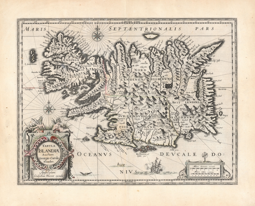
Tabula Islandiae Auctore Georgio Carolo Flandro.
1629 (undated) 15 x 19.5 in (38.1 x 49.53 cm) 1 : 1600000
1629 (undated) 15 x 19.5 in (38.1 x 49.53 cm) 1 : 1600000
Description
This is Willem and Joan Blaeu's 1644 map of Iceland, among the most influential and widely copied 17th-century maps of the island.
Sources
The map was engraved in 1628 by Jodocus Hondius the Younger, who credited it to Joris Carolus. Carolus was a noted Dutch navigator and explorer whose extensive travels to Spitzbergen, Davis Strait, and other islands of the North Atlantic - and whose own exaggerations of the extent of those travels - established him as an authority on the northern oceans. Carolus' travels did take him to Iceland more than once, but it may be that Hondius used the navigator's name specifically to incorporate the navigators' authority without necessarily relying on his information.No Exploration Required
Although Hondius credited Carolus for the map, its composition may well have been Hondius' work. It is mainly a synthesis of Ortelius's Islandia and the Mercator map, which the present work was intended to replace. Both precursor maps were derived from Bishop Gudbrandur, scholar and Archbishop of Holle. Thus, ultimately the information presented here is derived from the report of an actual Icelander. It is somewhat larger than the earlier works, but the topography is drawn from Ortelius while the toponymy - nearly 270 place names - is that of Mercator. The overall shape of the island is improved, but inland there is little new detail: its chains of mountains, and particularly the fiery Mount Hekla, remain the dominant features of the interior. The map does introduce errors: the eastern lake of Lagarfjót, is presented as a fjord, and most notably the imaginary 'I. Gouberman' (the Islands of Gunnbjarnareyjar) off the western shore of the island.A Superb Engraving
This map, intended as a replacement of Mercator's map, was a worthy successor. The evocative mountains of the island place this among the most visually impressive of the maps of Hondius and Blaeu. The map has two fine compass roses, and a finely engraved sailing ship appears at the bottom along with two sedately-presented sea monsters. The scale cartouche at lower right is flanked by two sea-monster heads, and the beautiful cartouche combines a strapwork frame with floral elements and is topped with two reclining nereids (water nymphs tasked with overseeing the fates of sailors). Iceland's Mount Hekla is illustrated erupting massively - it was notorious even on mainland Europe and was thought to be a literal gate to Hell. Also named are some of the country's other volcanoes, such as Eyjafjallajökull (here spelled Eiapialla hokel), which famously erupted in 2010. The absence of the currently-erupting volcano on the Reykjanes Peninsula, Fagradalsfjall, is unsurprising: the 2021 eruption is the first of that volcano to occur in recorded history.Publication History and Census
The map was engraved in and around 1628 by Jodocus Hondius Jr. After he died the next year, his widow sold the plates to Willem Blaeu, who included it in his Appendix to the Mercator atlases. Thereafter, Blaeu replaced Hondius' imprint with his own, and the map would thus appear in Blaeu's atlases throughout the remainder of the firm's existence. This second state example corresponds typographically to the 1644 Latin edition of the Blaeu Atlas Novus. Separate examples of the map are well represented in institutional collections and can be found on the market occasionally.CartographerS
Willem Janszoon Blaeu (1571 - October 18, 1638), also known as Guillaume Blaeu and Guiljelmus Janssonius Caesius, was a Dutch cartographer, globemaker, and astronomer active in Amsterdam during the late 16th and early 17th centuries. Blaeu was born 'Willem Janszoon' in Alkmaar, North Holland to a prosperous herring packing and trading family of Dutch Reformist faith. As a young man, he was sent to Amsterdam to apprentice in the family business, but he found the herring trade dull and instead worked for his cousin 'Hooft' as a carpenter and clerk. In 1595, he traveled to the small Swedish island of Hven to study astronomy under the Danish Enlightenment polymath Tycho Brahe. For six months he studied astronomy, cartography, instrument making, globe making, and geodesy. He returned to Alkmaar in 1596 to marry and for the birth of his first son, Johannes (Joan) Blaeu (1596 – 1673). Shortly thereafter, in 1598 or 1599, he relocated his family to Amsterdam where he founded the a firm as globe and instrument makers. Many of his earliest imprints, from roughly form 1599 - 1633, bear the imprint 'Guiljelmus Janssonius Caesius' or simply 'G: Jansonius'. In 1613, Johannes Janssonius, also a mapmaker, married Elizabeth Hondius, the daughter of Willem's primary competitor Jodocus Hondius the Elder, and moved to the same neighborhood. This led to considerable confusion and may have spurred Willam Janszoon to adopt the 'Blaeu' patronym. All maps after 1633 bear the Guiljelmus Blaeu imprint. Around this time, he also began issuing separate issue nautical charts and wall maps – which as we see from Vermeer's paintings were popular with Dutch merchants as decorative items – and invented the Dutch Printing Press. As a non-Calvinist Blaeu was a persona non grata to the ruling elite and so he partnered with Hessel Gerritsz to develop his business. In 1619, Blaeu arranged for Gerritsz to be appointed official cartographer to the VOC, an extremely lucrative position that that, in the slightly more liberal environment of the 1630s, he managed to see passed to his eldest son, Johannes. In 1633, he was also appointed official cartographer of the Dutch Republic. Blaeu's most significant work is his 1635 publication of the Theatrum orbis terrarum, sive, Atlas Novus, one of the greatest atlases of all time. He died three years later, in 1638, passing the Blaeu firm on to his two sons, Cornelius (1616 - 1648) and Johannes Blaeu (September 23, 1596 - December 21, 1673). Under his sons, the firm continued to prosper until the 1672 Great Fire of Amsterdam destroyed their offices and most of their printing plates. Willem's most enduring legacy was most likely the VOC contract, which ultimately passed to Johannes' son, Johannes II, who held the position until 1617. As a hobbyist astronomer, Blaeu discovered the star now known as P. Cygni. More by this mapmaker...
Jodocus Hondius (October, 14 1563 - February 12, 1612) was an important Dutch cartographer active in the late 16th and early 17th centuries. His common name, Jodocus Hondius is actually a Latinized version of his Dutch name, Joost de Hondt. He is also sometimes referred to as Jodocus Hondius the Elder to distinguish him from his sons. Hondius was a Flemish artist, engraver, and cartographer. He is best known for his early maps of the New World and Europe, for re-establishing the reputation of the work of Gerard Mercator, and for his portraits of Francis Drake. Hondius was born and raised in Ghent. In his early years he established himself as an engraver, instrument maker and globe maker. In 1584 he moved to London to escape religious difficulties in Flanders. During his stay in England, Hondius was instrumental in publicizing the work of Francis Drake, who had made a circumnavigation of the world in the late 1570s. In particular, in 1589 Hondius produced a now famous map of the cove of New Albion, where Drake briefly established a settlement on the west coast of North America. Hondius' map was based on journal and eyewitness accounts of the trip and has long fueled speculation about the precise location of Drake's landing, which has not yet been firmly established by historians. Hondius is also thought to be the artist of several well-known portraits of Drake that are now in the National Portrait Gallery in London. In 1593, Hondius returned to Amsterdam, where he remained until the end of his life. In 1604, he purchased the plates of Gerard Mercator's Atlas from Mercator's grandson. Mercator's work had languished in comparison to the rival atlas, Theatrum Orbis Terrarum by Ortelius. Hondius republished Mercator's work with 36 additional maps, including several which he himself produced. Despite the addition of his own contributions, Hondius recognizing the prestige of Mercator's name, gave Mercator full credit as the author of the work, listing himself as the publisher. Hondius' new edition of Mercator revived the great cartographer's reputation and was a great success, selling out after a year. Hondius later published a second edition, as well as a pocket version called the Atlas Minor. The maps have since become known as the "Mercator/Hondius series". Between 1605 and 1610 Hondius was employed by John Speed to engrave the plates for Speed's The Theatre of the Empire of Great Britaine. Following Hondius' death in 1612, his publishing work in Amsterdam was continued by his widow and two sons, Jodocus II and Henricus. Later his family formed a partnership with Jan Jansson, whose name appears on the Atlasas co-publisher after 1633. Eventually, starting with the first 1606 edition in Latin, about 50 editions of the Atlas were released in the main European languages. In the Islamic world, the atlas was partially translated by the Turkish scholar Katip Çelebi. The series is sometimes called the 'Mercator/Hondius/Jansson' series because of Jansson's later contributions. Hondius' is also credited with a number of important cartographic innovations including the introduction of decorative map borders and contributions to the evolution of 17th century Dutch wall maps. The work of Hondius was essential to the establishment Amsterdam as the center of cartography in Europe in the 17th century. Learn More...
Guðbrandur Þorláksson or Gudbrand Thorlakssøn (c. 1542 - July 20 1627) was bishop of Hólar, Iceland from April 1571 until his death. He was the longest-serving bishop in Iceland. He is known for printing the first complete Icelandic translation of the Bible, and for providing the data for the first accurate maps of Iceland, printed at the end of the sixteenth century by Ortelius and Mercator. He was the son of the priest Þorláks Hallgrímssonar, and Helga Jónsdóttir, daughter of the lawyer Jón Sigmundsson. He studied at Hólar College from 1553 to 1559 before studying theology and logic at the University of Copenhagen: Guðbrandur was one of the first Icelanders to study in Denmark instead of in Germany. He returned to Iceland in 1564 to serve as rector of the Skálholt School before becoming a priest. In 1571 he was named Bishop of Hólar by the Danish King Frederick II; he would serve as bishop of Hólar for 56 years.
As bishop, Guðbrandur focused on printing religious works - including hymns, and the Bible - in Icelandic. He printed nearly 100 books - many of which he wrote and translated himself. In addition to cementing the Reformation firmly in Iceland, his efforts to accurately translate these works are credited with fundamentally strengthening the Icelandic language overall.
A well-rounded scholar, Guðbrandur maintained interests in natural history, astronomy, and surveying. He is credited with the drafting of at least one new map of Iceland, upon which the first printed maps of the Island by Abraham Ortelius and Gerard Mercator were based. Learn More...
Joris Carolus (c. 1566 - c. 1636) was a Dutch cartographer, explorer, navigator, and soldier. He is thought to have been a native of Enkhuizen, in the Netherlands. Nothing is known of his youth, but he served as a soldier in the Eighty Years War, losing a leg at the Siege of Ostend (1601–04.) Contemporaries thereafter referred to him as 'Wooden Leg.' He survived the loss, and went on to learn the art of navigation, becoming a pilot for both the Noordsche Compagnie and the Vereenigde Oost-Indische Compagnie. In 1614 in the service of the Noordsche Compagnie he took part in an expedition to Spitsbergen, during which he produced a map of the islands which would remain the standard Dutch map of the newly discovered coastlines for many years. Carolus claimed to have reached 83° N during this voyage. The following year the Noordsche Compagnie sent him to the Davis Strait region - where he claimed to have sailed to the (impossible) latitude of 80° N. The chart of this voyage is now lost, but Carolus described Baffin Bay later, saying it extended to 79° N and was enclosed by land. in 1617 he was sent out again and claimed to have discovered New Holland and Opdams Island, about twenty miles east of Iceland. His travels appear to have taken him more than a few times to Iceland, and his synthesis of Ortelius' and Mercator's maps of the island would become the dominant depiction of it beginning in 1630. When age and infirmity caught up with him, he became a teacher of navigation in Amsterdam, publishing a book of charts to supplement this (the extremely rare Het nieuw vermeerde Licht, ghenaemt de Sleutel van’t Tresoor, Spiegel, Gesicht, ende vierighe Colon des Grooten Zeevaerts). Learn More...
Source
Blaeu, J., Théâtre du Monde ou Nouvel Atlas, (Amsterdam: Blaeu) 1644.
The classic Dutch atlas, whose publication ushered in the Dutch golden age of cartography. Willem Jansz Blaeu had been, since 1604, producing engraved maps for sale; these were separate issues (and all consequently extremely rare) until the publishing of Blaeu's Appendix in 1630 and 1631, which also included a number of maps purchased from the widow of Jodocus Hondius, (for example his famous iteration of John Smith's map of Virginia.) In 1634, he announced his intention to produce a new world atlas in two volumes, entitled Theatrum Orbis Terrarum, sive Atlas Novus (Théâtre du Monde ou Nouvel Atlas) (in an effort to invoke the successful work of the same title produced by Ortelius the previous century, while reinforcing the notion of it being a new work.) This work was published first in German in 1634, followed by Latin, Dutch and French editions in 1635. Blaeu's maps have always been noted for the quality of their paper, engraving and fine coloring, and this was the intent from the very start. The 1634 announcement of the upcoming work described it: 'All editions on very fine paper, completely renewed with newly engraved copperplates and new, comprehensive descriptions.' (van der Krogt, p,43) Many of the most beautiful and desirable maps available to the modern collector were printed and bound in Blaeu's atlases. Willem's son, Joan, would go on to add further volumes to the Atlas Novus, concurrently printing new editions of the first two volumes with additional maps, in effect making these new editions an entirely new book. Under Joan there would be nine Latin editions, twelve French, at least seven Dutch, and two German. This exceedingly successful work would be the mainstay of the Blaeu firm until 1661, at which point the work was supplanted by Joan Blaeu's masterwork Atlas Maior in 1662.
Condition
Very good. Some areas of scuffing with minor loss to upper border and one rhumb line. Else excellent with a bold strike, heightened with delicate original color.
References
OCLC 828267220. van der Krogt 1250 2.2 variant a. cf. Rumsey 10017.026 (1665 variant b.).