This item has been sold, but you can get on the Waitlist to be notified if another example becomes available, or purchase a digital scan.
1587 / 1603 Abraham Ortelius Map of Iceland Surrounded with Monsters
Iceland-ortelius-1587-3$8,750.00

Title
Islandia.
1587 (dated) 13.25 x 19.25 in (33.655 x 48.895 cm) 1 : 1700000
1587 (dated) 13.25 x 19.25 in (33.655 x 48.895 cm) 1 : 1700000
Description
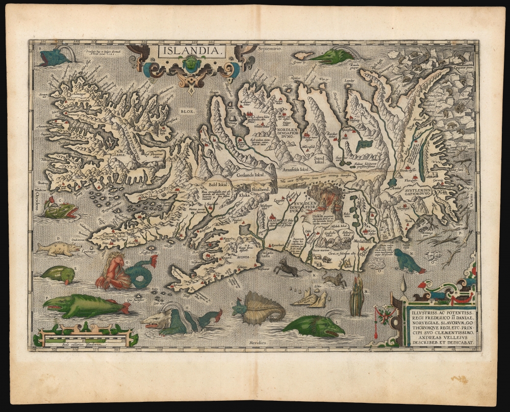
This is a superb example of Abraham Ortelius' 1587 map of Iceland, in a desirable 1603 Vrients edition with original color. Ortelius' Islandia is arguably the most famous decorative map, being the 'monster map' par excellence, as it presents a menagerie of the sea monsters typically found on early maps. The map is geographically important as well. Beyond strongly evoking Iceland's astonishing terrain with its vigorously engraved mountains, it is remarkably accurate since it is the first map of Iceland derived from the contemporaneous work of an Icelander, Gudbrandur Thorlaksson (Guðbrandur Þorláksson; c. 1542 - 1627).
The North Edge of the World
Despite being settled by Norse mariners in the 9th century, Iceland was nearly as remote to European navigators as the Americas or Africa. It appeared first, nearly unrecognizable, on the 1482 Ulm Ptolemy map of the world. The first map specifically of Iceland, the 1528 Bordone, contains a single place name: 'Islanda'. The first significant breakthrough occurred in 1539 with the printing of Olaus Magnus' Carta Marina, just two copies of which survive. This nine-sheet woodcut set the standard for the mapping of northern Europe for the remainder of the century. It informed Ortelius' 1570 Septentrionalium Regionum, both for his mapping of Scandinavia and of Iceland itself. Its abundant illustrations provided many of the decorative elements apparent here in Ortelius' Islandia. Nevertheless, the Olaus Magnus mapping of Iceland - though improved over the Bordone - is largely imaginary.The Bishop's Map
Enter Ortelius' map, the first to present the island with accurate detail, topography, and toponomy - it is superior to every preceding map of Iceland. Ortelius did not perform personal surveys; instead, he sourced and compiled cartographic data from the best authorities with scrupulous attribution. In this case, he credits the Danish priest and historiographer Anders Sørensen Vedel (1542 - 1616). But Vedel likely did not visit Iceland, and it is not credible that he could have produced such an accurate and detailed map without having done so. It is believed that the map was provided to Vedel by an Icelander, specifically Gudbrandur Thorlaksson (1542 - 1627), Bishop of Holar. Thorlaksson was a mathematician and astronomer, thus equipped with the necessary cartographic skills. Moreover, there are surviving lists of Icelandic settlements and geographical features positively attributed to Thorlaksson that would have been necessary in producing this map.The Wonders of the Sea
While the topography and toponymy of Iceland presented here are attributable to Thorlaksson, the teeming waters are populated with elements drawn from the 1539 Olaus Magnus map. Each creature and other notable wonders are assigned a letter, which keys to a text on the verso. Many of these creatures can be attributed to whale sightings, while others resemble recognizable walruses and rays. Some, such as the hippocampus (Hroshvalur), come from ancient myth. Others, such as the sea-bulls marked 'K', are fantastical. The ice floes on the northeast coast and the bears gamboling upon them are drawn from Olaus Magnus. Also noted are floating lumps of ambergris and floes of driftwood - an essential resource in tree-starved Iceland! The sagas discuss families warring over the right to harvest driftwood.Publication History and Census
Although dated 1585, this map did not appear until the 1587 French edition of the Theatrum. From that point, it remained unchanged for the remainder of its publication run. Van den Broecke notes a possible proof state - lacking the identifying letters for the monsters - but is skeptical that it actually exists (having appeared in a sole 1992 auction record). Apart from this phantom, the map is known in a single state. The present example appeared in the 1603 Latin edition of Ortelius's Theatrum, published by Vrients. This edition was limited to 300 copies; maps exhibiting original color applied during Vrients' executorship over the late Ortelius' atlas are particularly sought after for their quality. While various editions of this map are well represented in institutional collections, we see no example of this edition listed in OCLC.CartographerS
Abraham Ortelius (April 14, 1527 - June 28, 1598) also known as Ortels, was a cartographer, geographer, and cosmographer of Brabant, active in Antwerp. He was the creator of the first modern atlas, Theatrum Orbis Terrarum and is a seminal figure in the history of cartography. Along with Gerard Mercator and Gemma Frisius, he was a founder of the Netherlandish school of cartography. His connections with Spain - culminating in his 1575 appointment as Royal Cartographer to King Phillip II of Spain - gave him unmatched access to Spanish geographical knowledge during a crucial period of the Age of Discovery. Ortelius was born in 1527 in Antwerp. In 1547 he entered the Antwerp Guild of Saint Luke as an illuminator of maps. He began trading in books, prints, and maps, traveling regularly to the Frankfurt book and print fair, where in 1554 he met Mercator. He accompanied Mercator on journeys throughout France in 1560 and it was at this time, under Mercator's influence, that he appears to have chosen his career as a scientific geographer. His first published geographic work appeared in 1564, an eight-sheet cordiform world map. A handful of other maps preceded the 1570 publication of the first edition of the Theatrum Orbis Terrarum, which would prove to be his life work. Appearing with but 53 maps in its first edition, Ortelius' work expanded with new maps added regularly. By 1592, it had 134 maps. Many of Ortelius' maps remained the standard for nearly a century. He traveled extensively, but his genius was as a compiler, locating the best informed maps on which to base his own. His contacts throughout Europe and extending even (via the Portuguese) to the Far East were formidable. Moreover, many of his maps were based on his own scholarship, particularly his historical works. His theories of geography were particularly ahead of his time with respect to the notion of continental drift, the possibility of which he mused on as early as 1596, and which would be proven correct centuries later.
In a sense his greatest achievement was his successful navigation of the religious and political violence endemic to his city throughout his adult life: The Dutch Revolt, or Eighty Years' War (1568 - 1648), fully embroiled Antwerp. Although outwardly and officially recognized as Catholic (Arias Montanus vouched for Ortelius' Catholic orthodoxy prior to his appointment as Royal Geographer), Ortelius was able to separate himself from the religious furor which characterized the war in the low countries. Ortelius showed a glimpse of himself in a letter to a friend, regarding humanist Justus Lipsius: 'I do not know whether he is an adherent of the Pope or a Calvinist, but if he has ears to hear, he will neither be one nor the other, for sins are committed on both sides'. Ortelius' own explorations of Biblical history in his maps, and the Christogram contained in his own motto, suggest him to be a religious man, but his abjuration of political religious authorities mark him as an individualist. His tombstone at St Michael's Præmonstratensian Abbey in Antwerp bears the inscription, Quietis cultor sine lite, uxore, prole. ('served quietly, without accusation, wife, and offspring.') More by this mapmaker...
Guðbrandur Þorláksson or Gudbrand Thorlakssøn (c. 1542 - July 20 1627) was bishop of Hólar, Iceland from April 1571 until his death. He was the longest-serving bishop in Iceland. He is known for printing the first complete Icelandic translation of the Bible, and for providing the data for the first accurate maps of Iceland, printed at the end of the sixteenth century by Ortelius and Mercator. He was the son of the priest Þorláks Hallgrímssonar, and Helga Jónsdóttir, daughter of the lawyer Jón Sigmundsson. He studied at Hólar College from 1553 to 1559 before studying theology and logic at the University of Copenhagen: Guðbrandur was one of the first Icelanders to study in Denmark instead of in Germany. He returned to Iceland in 1564 to serve as rector of the Skálholt School before becoming a priest. In 1571 he was named Bishop of Hólar by the Danish King Frederick II; he would serve as bishop of Hólar for 56 years.
As bishop, Guðbrandur focused on printing religious works - including hymns, and the Bible - in Icelandic. He printed nearly 100 books - many of which he wrote and translated himself. In addition to cementing the Reformation firmly in Iceland, his efforts to accurately translate these works are credited with fundamentally strengthening the Icelandic language overall.
A well-rounded scholar, Guðbrandur maintained interests in natural history, astronomy, and surveying. He is credited with the drafting of at least one new map of Iceland, upon which the first printed maps of the Island by Abraham Ortelius and Gerard Mercator were based. Learn More...
Source
Ortelius, A., Theatrum Orbis Terrarum, (Antwerp: Vrients) 1603.
Abraham Ortelius' magnum opus, Theatrum Orbis Terrarum, was the world's first regularly produced atlas, which 'set the standards for later atlases . . . It was the first undertaking of its kind to reduce the best available maps to an uniform format.' (Koeman) A modestly-sized work of fifty-three maps in its first edition of May 1570, it was an immediate success: there were three further editions that year, and the work remained in print for a total of 32 editions, the last of which was 1641, well after its author's 1598 death. Ortelius added to his atlas constantly, and by 1595 the Theatrum contained 147 maps. Ortelius is renowned generally as an editor, and indeed much of the Theatrum is compiled from a variety of sources: in such cases, Ortelius was scrupulous in naming his sources. But Ortelius was also a mapmaker in his own right: many of his maps are a distillation of various sources into his own work, and there were many maps - particularly in his atlas of Biblical and ancient history Parergon - which were entirely Ortelius' work. In his role as an editor, Ortelius followed in the footsteps of Munster, whose Cosmographia was, until Ortelius, the best window on the world for the curious European reader. In terms of the artistry of his maps, Ortelius oversaw the first great flourishing of copperplate engraving in the service of cartography to occur in Northern Europe. Ortelius' work provided the model for the atlases of Mercator, Hondius, Blaeu and all their progeny in the 17th century - many of whom were to produce faithful editions of Ortelius' maps in their own productions.
Condition
Excellent. Light toning and some discoloration in margin, not impacting printed image. Else fine with generous margins and a bold strike.
References
OCLC 159851001. Campbell, T., Early Maps, plate 40; van den Broecke, M., Ortelius Atlas Maps 161.