This item has been sold, but you can get on the Waitlist to be notified if another example becomes available, or purchase a digital scan.
1930 Rand McNally Pictorial Map of Idaho, Montana, and Wyoming
IdahoMontanaWyoming-randmcnally-1930s$50.00

Title
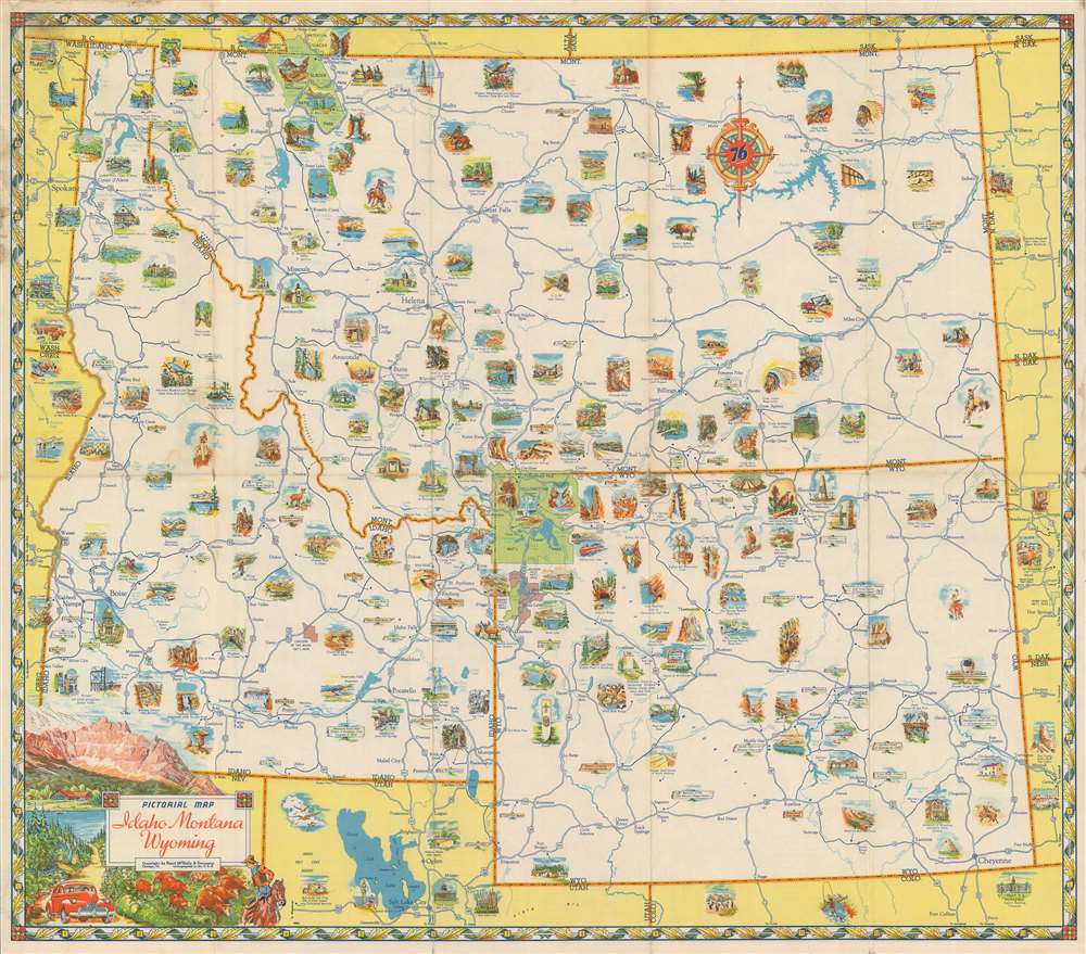
Pictorial Map Idaho Montana Wyoming.
1930s (undated) 19.25 x 22 in (48.895 x 55.88 cm) 1 : 2000000
1930s (undated) 19.25 x 22 in (48.895 x 55.88 cm) 1 : 2000000
Description
Centered on Yellowstone National Park, this c. 1930 Rand McNally pictorial map of Idaho, Montana, and Wyoming promotes a romantic view of the American West. Yellowstone, the first national park in the U.S., fascinates people across the U.S. and the world and is famous for its geothermal activity, especially Old Faithful, illustrated here. The 'great outdoors' is synonymous with the American West, and Rand McNally uses that connotation to their advantage. People are depicted fishing, working cattle ranches, and taking in the fantastic scenery. National parks, monuments, and forests are all labeled, while the flora, fauna, and landscapes they were created to protect are front and center. The region's state and national highways crisscross the map, allowing vacationers to plan which sites to visit and how best to access each one. After spending some time looking at this map, one can't help but want to take a 'Great American Road Trip'!
Publication History and Census
This map was created and published by Rand McNally c. 1930. We have been unable to trace any other examples.Cartographer
Rand, McNally and Co. (fl. 1856 - present) is an American publisher of maps, atlases and globes. The company was founded in 1856 when William H. Rand, a native of Quincy, Massachusetts, opened a print shop in Chicago. Rand hired the recent Irish immigrant Andrew McNally to assist in the shop giving him a wage of 9 USD per week. The duo landed several important contracts, including the Tribune's (later renamed the Chicago Tribune) printing operation. In 1872, Rand McNally produced its first map, a railroad guide, using a new cost effective printing technique known as wax process engraving. As Chicago developed as a railway hub, the Rand firm, now incorporated as Rand McNally, began producing a wide array of railroad maps and guides. Over time, the firm expanded into atlases, globes, educational material, and general literature. By embracing the wax engraving process, Rand McNally was able to dominate the map and atlas market, pushing more traditional American lithographic publishers like Colton, Johnson, and Mitchell out of business. Eventually Rand McNally opened an annex office in New York City headed by Caleb S. Hammond, whose name is today synonymous with maps and atlases, and who later started his own map company, C. S. Hammond & Co. Both firms remain in business. More by this mapmaker...
Condition
Good. Exhibits wear along original fold lines and light soiling. Text on verso.