
This item below is out of stock, but another example (left) is available. To view the available item, click "Details."
Details
1824 Schoolgirl Manuscript Map of Illinois
1824 (undated) $1,000.00
1828 Finley Map of Illinois
Illinois-finley-1828$175.00

Title
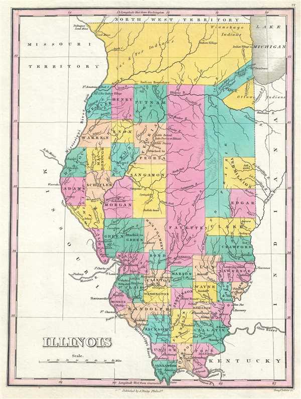
Illinois.
1828 (undated) 11.75 x 9 in (29.845 x 22.86 cm) 1 : 2200000
1828 (undated) 11.75 x 9 in (29.845 x 22.86 cm) 1 : 2200000
Description
This is an 1828 Anthony Finley map of Illinois. The map depicts the state and the region from the Northwest Territory to Kentucky and from the Missouri Territory to Indiana in Finley's classic minimalist style. Rivers, roads, canals, and some topographical features are illustrated. Color coding at the county level allows for easy differentiation between the counties.
Finley's map of Illinois is particularly interesting and important due to its portrayal of the rapidly changing American Indian situation in the northern part of the state. In 1827, northern Illinois was a confined territory assigned to Sac and Fox, Ottowa, and Winnebago Indians. Of note is the fact that the commercial interests of European settlers divides the otherwise singular American Indian lands to provide river access to Chicago and Lake Michigan. Within these lands, a handful of settlements, labeled Indian Villages, are included. Within a few short years of this map's construction, most of these tribes were forcibly removed to the Indian Territory, modern-day Oklahoma. This map was updated yearly from 1824 to the mid-1830s. A full series of these maps is a powerful illustration of both the American Indian relocations and the Westward Expansion.
This map was engraved by Young and Delleker for the 1828 edition of Anthony Finley's General Atlas.
Cartographer
Anthony Finley (August 25, 1784 - June 9, 1836) was an American book and map publisher based in Philadelphia, Pennsylvania. Finley was born in Philadelphia in 1784. He opened a bookshop and publishing house at the Northeast corner of Fourth and Chestnut Street, Philadelphia in 1809. His earliest known catalog, listing botanical, medical and other scientific works, appeared in 1811. His first maps, engraved for Daniel Edward Clarke’s Travels in Various Countries of Europe, Asia, and Africa also appear in 1811. His first atlas, the Atlas Classica, was published in 1818. He soon thereafter published the more significant A New American Atlas and the New General Atlas…, both going through several editions from 1824 to 1834. Although most of Finley's cartographic material was borrowed from European sources, his atlases were much admired and favorably reviewed. In addition to his work as a printer, Finley ran unsuccessfully on the 1818 Democratic ticket for Philadelphia Common Council. He was a founding officer of the Philadelphia Apprentices’ Library, and a member of both the American Sunday-School Union and the Franklin Institute. He was also an ardent supporter of the American Colonization Society, an organization dedication to returning free people of color to Africa - which led to the founding of Liberia. Much of his wealth was dedicated to supporting this cause. Finley was active as a publisher until his 1836 death, apparently of a 'lingering illness.' Shortly thereafter advertisements began appearing for his map business and plates, most of which were acquired by Samuel Augustus Mitchell. More by this mapmaker...
Source
Finley, Anthony, A New General Atlas, Comprising a Complete Set of Maps, representing the Grand Divisions of the Globe, Together with the several Empires, Kingdoms and States in the World; Compiled from the Best Authorities, and corrected by the Most Recent Discoveries, Philadelphia, 1828.
Condition
Very good. Blank on verso.
References
Rumsey 0282.031 (1827 edition). Phillips (Atlases) 4314, 760, 752, 6045.