This item has been sold, but you can get on the Waitlist to be notified if another example becomes available, or purchase a digital scan.
1938 T. Johnson Pictorial Map of Illinois
Illinois-tjohnson-1938$125.00


Title
Illinois Its Geography Its History.
1938 (dated) 22 x 17 in (55.88 x 43.18 cm)
1938 (dated) 22 x 17 in (55.88 x 43.18 cm)
Description
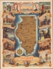
This is a striking 1938 J. Theodore Johnson pictorial map of Illinois. This map is likely one of the last pieces Johnson produced in Chicago while working with the Works Progress Administration initiative Illinois Federal Art Project. It illustrates the state as it emerged from the Great Depression (1929 - 1939) and was seeking to brand itself as an emerging hub of industry and commerce.
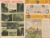
The verso further emphasizes 'Illinois the Beautiful', with striking photos of local sites, a textual history, and bullet points generally promoting the state's industrial capacity.
A Closer Look
The view presents Illinois as an island, isolated from surrounding states by rivers and lakes, an aesthetic statement underscored by the nautical compass rose in the lower left. Illustrations throughout highlight historical sites and the state's signature industries. The map is surrounded by colorful pictorial vignettes chronicling the history of Illinois from Jacques Marquette's (1637 - 1675) arrival in 1673, to the 1893 World's Columbian Exposition. Portraits of Shadrach Bond and Henry Horner, the first and present governors of Illinois, flank a simple view of the Chicago skyline at the top of the page.The verso further emphasizes 'Illinois the Beautiful', with striking photos of local sites, a textual history, and bullet points generally promoting the state's industrial capacity.
Publication History and Census
This image was drawn by Illinois artist John Theodore Johnson and published in 1938 by the State of Illinois. The verso bears the elusive 'L.I.P. and B.A. Union' stamp, often misread as 'LIBABA'. This refers to the Lithographers International Protective and Beneficial Association, a labor union supporting the printing trade. We are aware of only one edition.Cartographer
Theodore Taylor Johnson (b. 1818 fl. c. 1849 - 1866) was an American travel writer. He is best known for his work Sights in the Gold Region, and Scenes by the Way, the first published book relating personal experiences in the gold fields of California. More by this mapmaker...
Condition
Very good.