This item has been sold, but you can get on the Waitlist to be notified if another example becomes available, or purchase a digital scan.
1897 Poole Brothers Railroad Map of the Illinois Central Railroad
IllinoisCentral-poole-1897$500.00

Title
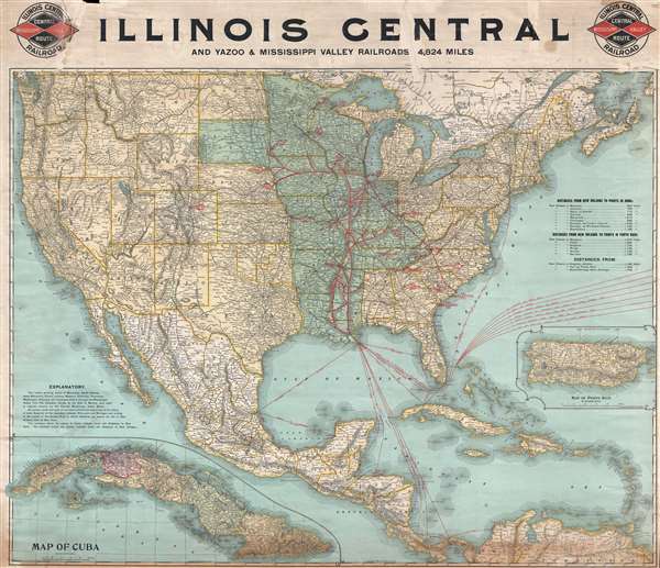
Illinois Central and Yazoo and Mississippi Valley Railroads. 4,824 miles.
1897 (dated) 32.5 x 37 in (82.55 x 93.98 cm) 1 : 6110000
1897 (dated) 32.5 x 37 in (82.55 x 93.98 cm) 1 : 6110000
Description
This is an 1897 Poole Brothers railroad map of the Illinois Central and Yazoo and Mississippi Valley railroads. The map depicts the continental United States from the Pacific Ocean to the Atlantic Ocean and from the Canada to Mexico, the Gulf of Mexico, and the Antilles. A highly detailed railroad map, the routes owned by the Illinois Central are highlighted in red and all the stops along these routes are labeled. Major stops are highlighted in bold red lettering. Outside of the Illinois Central network, myriad different rail lines are illustrated and the company running that line is noted along with numerous stops along each route. Sea routes from New Orleans to locations in Central America, the Caribbean, and Europe are illustrated and labeled with destination and distance, along with routes originating from Havana. An inset map of Puerto Rico is included along the right border. An inset map of Cuba is situated I the bottom left corner.
The Yazoo and Mississippi Valley Railroad as incorporated in 1882 as part of the Illinois Central Railroad. The original line ran from Jackson, Mississippi to Yazoo City, Mississippi but was later expanded through the Mississippi Delta to Memphis, Tennessee. Several acquisitions in the following years, including the Mississippi and Tennessee Railroad, would steadily increase the miles of track owned by the Illinois Central and would lead to the creation of the Louisville, New Orleans, and Texas Railway.
The Yazoo and Mississippi Valley – or its predecessor, the Yazoo Delta Railway – features in quite a few blues songs as the Yellow Dog Railroad. Apparently, locals assigned the words 'Yellow Dog' to the Y.D. on freight cars used by the railroad. The Yazoo and Mississippi Valley depot at Rosedale, Mississippi has been designated as a site on the Mississippi Blues Trail. The marker commemorates the original lyrics of legendary blues artist Robert Johnson's 'Traveling Riverside Blues,' which traced the route of the Yazoo and Mississippi Valley. 'Traveling Riverside Blues' has been covered by several other musicians, including Led Zeppelin and Eric Clapton.
This map was produced by Poole Brothers in 1897.
Cartographer
Poole Brothers (1878 - 1968) were a Chicago based firm active in the late 19th and early 20th century with an initial focus on promotional railroad maps. Poole Brothers was founded by George Amos Poole (March 20, 1843 – September 7, 1918). In 1868, Poole, along with his uncle William H. Rand (1828 - 1915) and Andrew McNally (1836 - 1904), purchased the Chicago Tribune's job printing plant and formed the firm Rand McNally. In 1878, he left Rand McNally to form, with his brother William H. Poole, Poole Brothers, a direct competitor to Rand McNally for the lucrative railroad business. Like many of its competitors, Poole Brothers maintained an office on Chicago's Printer's Row (downtown Loop district). Their earliest known work is an 1880 map of Yellowstone National Park. In 1887, Poole Brothers, Andrew McNally, and several others formed the United Typothetae of America, a master printers association. In 1848, they were cited, along with Rand McNally and George Cram, by the Federal Trade Commission for price fixing. Their earliest known work is an 1880 map of Yellowstone National Park. Afterward they went on to produce a vast range of maps and other print products including tickets, cards, coupons, and restaurant menus. In time Poole Brothers merged with Newman-Randolph, which was then acquired by the American Can Company in the early 1960s. The American Can Company liquidated its printing concerns later in the same decade. More by this mapmaker...
Condition
Good. Nearly all old tape repairs removed from recto and verso. Some loss along top border due to old tape removal. Patched holes and reinforced and repaired tears on verso along the top four inches. Top four inches reinforced. Blank on verso.