This item has been sold, but you can get on the Waitlist to be notified if another example becomes available, or purchase a digital scan.
1833 S.D.U.K. Map of Illinois, Missouri, Iowa and Indiana
IllinoisMissouri-sduk-1833$62.50

Title
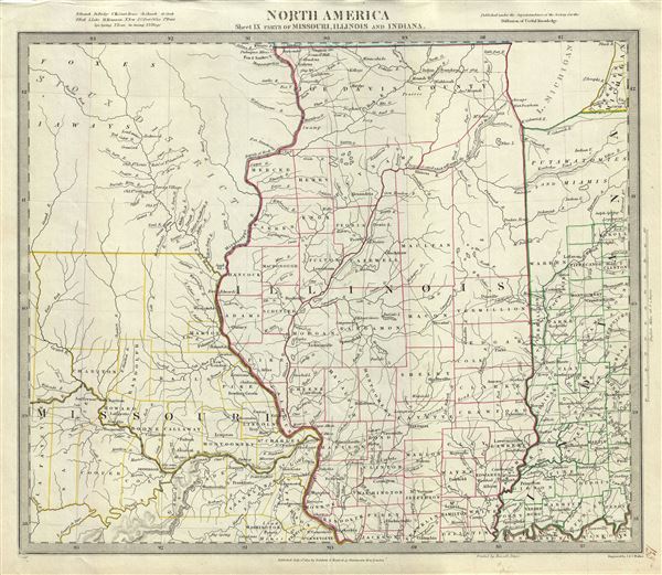
North America Sheet IX Parts of Missouri, Illinois and Indiana.
1833 (dated) 13.5 x 16 in (34.29 x 40.64 cm) 1 : 1770000
1833 (dated) 13.5 x 16 in (34.29 x 40.64 cm) 1 : 1770000
Description
This is a beautiful 1833 map of Illinois, Missouri, Iowa and Indiana issued by the S.D.U.K. The map covers parts of modern day Iowa, Illinois, Missouri and Indiana from the Sioux Territory south as far as the Kentucky border and east as far as Lake Michigan. Depicts a very early county configuration. The map is particularly interesting and important due to its portrayal of the rapidly changing American Indian situation. Several Indian tribes are identified, including the Sioux, Foxes, and others. Published in 1833 by Baldwin and Cradock of Paternoster Row for the Society for the Diffusion of Useful Knowledge, or S.D.U.K. Although the Society formally closed its doors in 1848, subsequent reissues of the S.D.U.K. atlas were printed well into the 1870s by Chapman and Hall, who acquired the original plates.
Cartographer
The "Society for the Diffusion of Useful Knowledge" (1826 - 1848) was a Whiggish organization founded in 1828 at the instigation of idealistic British lord Henry Peter Brougham. The admirable goal of the Society was to distribute useful information via a series of publications to the English working and middle classes. It promoted self-education and the egalitarian sharing of all knowledge. While closely tied to the London University and publishing houses on the order of Baldwin and Cradock, Chapman and Hall, and Charles Knight, the Society failed to achieve its many lofty goals in finally closed its doors in 1848. Most likely the failure of the Society resulted from its publications being too expensive for its intended lower to middle class markets and yet not large and fine enough to appeal to the aristocratic market. Nonetheless, it did manage to publish several extraordinary atlases of impressive detail and sophistication. Their most prominent atlas consisted of some 200 separately issued maps initially published by Baldwin and Cradock and sold by subscription from 1829 to 1844. Afterwards, the Society combined the maps into a single world atlas published under the Chapman and Hall imprint. In its day, this atlas was unprecedented in its quality, scope, and cost effectiveness. Today Society, or S.D.U.K. as it is commonly known, maps are among the most impressive examples of mid-19th century English mass market cartographic publishing available. The S.D.U.K. is especially known for its beautiful and accurately detailed city plans. More by this mapmaker...
Source
Maps of the Society for the Diffusion of Useful Knowledge, (London: Baldwin & Cradock), 1833.
Condition
Very good. Blank on verso.
References
Rumsey 0890.136. Phillips (Atlases) 794.