This item has been sold, but you can get on the Waitlist to be notified if another example becomes available, or purchase a digital scan.
1956 Moss Pictorial Map of Manhattan, New York City
IllustratedNewYork-moss-1956$87.50

Title
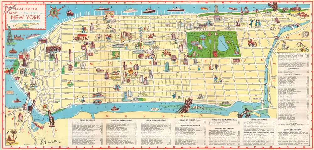
Illustrated Map of the City of New York.
1956 (dated) 13.75 x 29.75 in (34.925 x 75.565 cm)
1956 (dated) 13.75 x 29.75 in (34.925 x 75.565 cm)
Description
Providing a charming and entertaining visual summary of Manhattan's numerous museums, sites, and hotels, this 1956 Ira Ross pictorial map of Manhattan in New York City creates a perfect introduction to the 'Big Apple' for visiting tourists. The map depicts the borough in detail from Battery Park to the Met Cloisters and the Bronx and from the Hudson River to Brooklyn and Queens. Manhattan's famous street grid, with its parallel streets and avenues, is clearly labeled and easily navigated.
The city's most recognizable destinations, including the Metropolitan Museum of Art, the American Museum of Natural History, the Whitney Museum of Modern Art, and the Museum of Modern Art are all marked by vignettes highlighting their most well-known attributes: ancient sculpture, a Tyrannosaurus Rex, and modernist paintings. Other landmarks, such as the Chrysler Building, the Empire State Building, the Flatiron Building, the United Nations Headquarters, and the Washington Arch are illustrated in profile. Numerous hotels are highlighted, as are New York City mainstays like Macy's at Herald Square, Madison Square Garden, and even Yankee Stadium.
Other sites are more comically represented, such as a reading lion for the New York Public Library, a patient chasing a nurse at Bellevue Hospital, or caricatures of opera singers for the Metropolitan Opera House. A now lost part of New York City's, and America's popular culture, the automat, a fast food restaurant where foods and drinks were served out of vending machines is present throughout, with numerous automats marked by blue stars. The city's bridges, including the iconic Brooklyn Bridge, are sketched in profile as well. The city's numerous parks, such as Riverside Park, Fort Tryon Park, and, of course Central Park, stand out as green oases in a desert of yellow. The Statue of Liberty and Ellis Island are included along the left border in New York Harbor.
Publication History
This map was drawn by Ira Moss and published by Barry, Moss, and Shore in 1956.Cartographer
Ira Moss (fl. c. 1954 - 1956) was an American painter and graphic designer active in New York City during the mid-20th century. His corpus includes pictorial maps of New York City as well as national 'fish and game' maps. More by this mapmaker...
Condition
Very good. Light wear along original fold lines. Text and map of New York City Subway on verso.