1861 Mitchell Map of Illinois, Missouri, Iowa, Nebraska, and Kansas
ILMOIANEKS-mitchell-1861$200.00

Title
Illinois, Missouri, Iowa, Nebraska, and Kansas.
1860 (dated) 11 x 14 in (27.94 x 35.56 cm) 1 : 3600000
1860 (dated) 11 x 14 in (27.94 x 35.56 cm) 1 : 3600000
Description
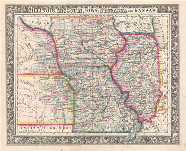
This is an 1861 Samuel Augustus Mitchell, Jr. map of Illinois, Missouri, Iowa, Nebraska, and Kansas. The map depicts the region from Nebraska and Kansas to Indiana and Kentucky and from Dacotah, Iowa, and Wisconsin to the Indian Territory, Missouri, and Kentucky. No map better encapsulates the industrial capacity of the northern United States at the outbreak of the Civil War. The rail network that was in place in Illinois and Iowa, along with those that were projected to be built, far the status of built lines and planned lines in Missouri, a slave state. It is interesting to note that all railroad construction, in both Iowa and Missouri, stops at the Missouri River, with no planned lines illustrated in either Nebraska or Kansas. One of the major factors that gave the Union an advantage was its industrial capacity. The exigencies of war also caused the North to exploit this potential with incredible speed. For example, by the war's end, over 15,000 miles of telegraph cable had been laid. The increase in the speed of communication and transportation allowed for the American Civil War to change the reality of warfare forever.
Individual counties are illustrated, labeled, and shaded different colors to allow for easy differentiation in both all five states, although counties are only illustrated in the eastern portion of Kansas and Nebraska. Cities, Chicago, Springfield, Des Moines, St. Louis, Kansas City, St. Joseph, Madison, and Omaha are labeled, along with myriad other towns and villages. Rivers, creeks, and lakes are illustrated as well, though not all are labeled.
This map was prepared by S. A. Mitchell Jr. for inclusion in the 1861 edition of Mitchell's New General Atlas. Like many American map publishers of this period, Mitchell did not regularly update his copyrights, consequently this map is dated and copyrighted to 1860: 'Entered according to Act of Congress in the Year 1860 by S. Augustus Mitchell Jr. in the Clerk's Office of the District Court of the U.S. for the Eastern District of Pennsylvania.'
Cartographer
Samuel Augustus Mitchell (March 20, 1792 - December 20, 1868) began his map publishing career in the early 1830s. Mitchell was born in Bristol, Connecticut. He relocated to Philadelphia in 1821. Having worked as a school teacher and a geographical writer, Mitchell was frustrated with the low quality and inaccuracy of school texts of the period. His first maps were an attempt to rectify this problem. In the next 20 years Mitchell would become the most prominent American map publisher of the mid-19th century. Mitchell worked with prominent engravers J. H. Young, H. S. Tanner, and H. N. Burroughs before attaining the full copyright on his maps in 1847. In 1849 Mitchell either partnered with or sold his plates to Thomas, Cowperthwait and Company who continued to publish the Mitchell's Universal Atlas. By about 1856 most of the Mitchell plates and copyrights were acquired by Charles Desilver who continued to publish the maps, many with modified borders and color schemes, until Mitchell's son, Samuel Augustus Mitchell Junior, entered the picture. In 1859, S.A. Mitchell Jr. purchased most of the plates back from Desilver and introduced his own floral motif border. From 1860 on, he published his own editions of the New General Atlas. The younger Mitchell became as prominent as his father, publishing maps and atlases until 1887, when most of the copyrights were again sold and the Mitchell firm closed its doors for the final time. More by this mapmaker...
Source
Mitchell, S. A., Mitchell's New General Atlas Containing Maps of the Various Countries of the World, Plans of Cities, Etc., embraced in Forty-Seven Quarto Maps, Forming a series of Seventy-Six Maps and Plans, together with Valuable Statistical Tables (Philadelphia: S. Augustus Mitchell, Jr.) 1861.
Mitchell's New General Atlas was published by Samuel Augustus Mitchell, Jr., the son of the prolific cartographer Samuel Augustus Mitchell. Many of the plates are derived from the his father's Mitchell's Universal Atlas, but not directly. The Mitchell's Universal Atlas was initially sold to Thomas, Cowperthwait, and Company in 1849, and again to Charles Deliver in 1856. It was Deliver who introduced the new vibrant color scheme, abandoning the older Mitchell's Universal Atlas green borders and themes for bright reds, blues, and yellows. Samuel Augustus Mitchell, Jr. acquired the Deliver plates in 1859. He added his own floral motif border, but doubled down on the vibrant color scheme, thus introducing to the American public the most vividly colored American atlas of the 19th century. In 1860, he published the first edition of his New General Atlas and, despite a slump in sales during the American Civil War, attained a level of success to rival his father. Mitchell would continue to publish the New General Atlas until 1887, when the firm formally closed.
Condition
Very good. Even overall toning. Light foxing. Blank on verso.
References
Rumsey 0565.023 (1860 edition).