1787 Bonne Map of Ancient India in the Time of Alexander the Great
ImperiaAntiquaIndia-bonne-1787$175.00

Title
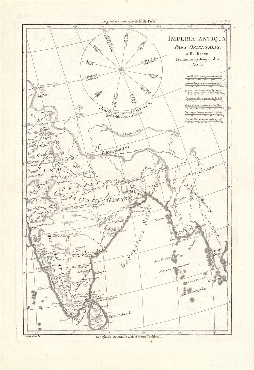
Imperia Antiqua, Pars Orientalis.
1787 (undated) 13.5 x 9 in (34.29 x 22.86 cm) 1 : 14000000
1787 (undated) 13.5 x 9 in (34.29 x 22.86 cm) 1 : 14000000
Description
This is a c. 1787 Rigobert Bonne map of Ancient India, depicted at the time of Alexander's conquest of the Punjab c. 320 BCE. The map, which appeared in Bonne and Desmarest's Atlas Encyclopedique, combines modern geographical knowledge with ancient (Latin) terminology and units of measurement.
The map is rich with information, including seven scales, a diagram of compass winds as described by Aristotle and updated by Pliny the Elder, latitude, and longitude given from both the Ferro Meridian and Paris. As might be expected, the description of some of the surrounding places and people are fantastical, such as the cannibals (antropophagi) supposedly inhabiting Upper Burma.
A Closer Look
This map depicts the Indian subcontinent and the Bay of Bengal, using Latin names for places and peoples as they appeared in Greek and later Roman sources discussing the conquests of Alexander the Great. The last conquests of Alexander before his death took place in the Punjab, at top-left here, in the 320s BCE. The map notes mountains, rivers, large settlements, and the names of regions and kingdoms. At right is the Bay of Bengal and Burma.The map is rich with information, including seven scales, a diagram of compass winds as described by Aristotle and updated by Pliny the Elder, latitude, and longitude given from both the Ferro Meridian and Paris. As might be expected, the description of some of the surrounding places and people are fantastical, such as the cannibals (antropophagi) supposedly inhabiting Upper Burma.
Publication History and Census
This map was made by Rigobert Bonne and appeared as map No. 7 in Bonne and Nicolas Desmarest's Atlas Encyclopedique, a very successful atlas that went through several editions in the late 18th century. The map is only independently cataloged among the holdings of the Bayerische Staatsbibliothek and the Universitätsbibliothek Eichstätt-Ingolstadt, while the entire Atlas Encyclopedique is more widely distributed among universities and research institutions.Cartographer
Rigobert Bonne (October 6, 1727 - September 2, 1794) was one of the most important French cartographers of the late 18th century. Bonne was born in Ardennes à Raucourt, France. He taught himself mathematics and by eighteen was a working engineer. During the War of the Austrian Succession (1740 - 1748) he served as a military engineer at Berg-op-Zoom. It the subsequent years Bonne became one of the most respected masters of mathematics, physics, and geography in Paris. In 1773, Bonne succeeded Jacques-Nicolas Bellin as Royal Cartographer to France in the office of the Hydrographer at the Depôt de la Marine. Working in his official capacity, Bonne compiled some of the most detailed and accurate maps of the period - most on an equal-area projection known erroneously as the 'Bonne Projection.' Bonne's work represents an important step in the evolution of the cartographic ideology away from the decorative work of the 17th and early 18th century towards a more scientific and practical aesthetic. While mostly focusing on coastal regions, the work of Bonne is highly regarded for its detail, historical importance, and overall aesthetic appeal. Bonne died of edema in 1794, but his son Charles-Marie Rigobert Bonne continued to publish his work well after his death. More by this mapmaker...
Source
Bonne, Rigobert and Desmarest, N., Atlas encyclopédique contenant la géographie ancienne, et quelques cartes sur la géographie du moyen age, la geographie moderne, et les cartes relatives a la géographie physique, (P1 81787-1788).. 7.
Condition
Very good.
References
OCLC 633583131, 643715158.