This item has been sold, but you can get on the Waitlist to be notified if another example becomes available, or purchase a digital scan.
1739 Hase and Homann Heirs Map of Russia and Asia
ImperiiRussici-homannheirs-1739$350.00

Title
Imperii Russici et Tatariae Universal.
1739 (dated) 19.5 x 23 in (49.53 x 58.42 cm) 1 : 4000000
1739 (dated) 19.5 x 23 in (49.53 x 58.42 cm) 1 : 4000000
Description
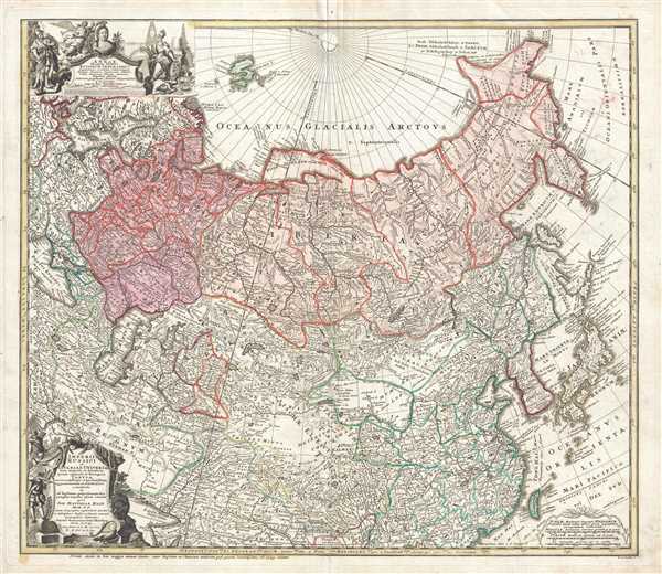
This is a 1739 Johann Matthias Hase and Homann Heirs map of Russia and Asia. The map depicts the region from Denmark, Norway, and the Black Sea to Japan and the Pacific Ocean and from the Arctic Ocean to India. Two intriguing cartographic missteps are illustrated here. The first is the depiction of Novaya Zemlya. Today, we know Novaya Zemlya is an archipelago in the Arctic Ocean off the northern coast of Russia, however here it is illustrated as a large peninsular protrusion. Evidently the southern coast of the islands had not yet been fully explored, thus Hase did not know that Navaya Zemlya was not connected to the mainland. Another landmass, ghosted in off the coast of Yeso, is labeled 'Terra Societatis Batavicæ'. Only the westernmost part of this region is illustrated, with the rest vanishing into the Pacific Ocean. This also was not an uncommon practice for cartographers during the 17th, 18th, and 19th centuries when they received information from explorer's reports, but it was inconclusive at best. Cartographers wanted to include the most up-to-date information, which meant that sometimes only a portion of a landmass would be included. Most likely the 'Terra Societatis Batavicæ' was one of the Kurile Islands that Maerten de Vries and Cornelis Jansz Coen charted during their 1643 expedition for the Dutch East Indiat Company. This is likely because the Straat de Vries is labeled just below the 'Terra Societatis Batavicæ', which was mapped by Vries and Coen. They were also the first European navigators to discover the forklike peninsulas of Sakhalin and map its coastline. Although, apparently the Castricum was mired in heavy fog as Vries and Coen attempted to explore these seas, leading to the inaccurate mapping of Hokkaido (Yeso) as a part of the Asian mainlain and not as a separate island.
A highly detailed map, myriad cities, towns, and villages are labeled, including Moscow, St. Petersburg, Berlin, and Peking. The Black Sea, Caspian Sea, and Aral Sea are all illustrated, along with numerous rivers and lakes. The Volga, Ganges, and Yangtze Rivers are among the rivers illustrated. A decorative title cartouche is situated in the lower left corner, while a cartouche bearing the map's dedication occupies the upper left corner. A cartouche containing the map's scale is included in the lower right corner.
This map was created by Johann Matthias Hase and published by Homann Heirs in 1739.
CartographerS
Johann Matthias Hase (January 14, 1684 - September 24, 1742) was a German cartographer, historical geographer, mathematician, and astronomer. Born in Augsburg, Hase was the son of a mathematics teacher, thus exhibited skill at mathematics early in life. He began attending the University of Helmstedt in 1701, where he studied mathematics under Rudolf Christian Wagner and then moved to the University of Leipzig to pursue a master's degree. He received his master's in 1707 and promptly returned to Augsburg to work as a teacher. However, he soon returned to Leipzig to serve as court master for two Augsburg patricians. There he became increasingly involved with geography, astronomy, and cartography as adjunct to the philosophical faculty. Hase was recommended for the position of chair of higher mathematics at the University of Wittenberg by his former professor, Christian Wolff, in 1715, but he was rejected. Five years later in 1720, however, he was named Professor of Mathematics at the University of Wittenberg. It is unclear exactly when Hase began working with the Homann Heirs firm, but he Hase compiled numerous maps under that imprint. He was also a prolific writer, publishing several treatises on universal history. More by this mapmaker...
Homann Heirs (1730 - 1848) were a map publishing house based in Nuremberg, Germany, in the middle to late 18th century. After the great mapmaker Johann Baptist Homann's (1664 - 1724) death, management of the firm passed to his son Johann Christoph Homann (1703 - 1730). J. C. Homann, perhaps realizing that he would not long survive his father, stipulated in his will that the company would be inherited by his two head managers, Johann Georg Ebersberger (1695 - 1760) and Johann Michael Franz (1700 - 1761), and that it would publish only under the name 'Homann Heirs'. This designation, in various forms (Homannsche Heirs, Heritiers de Homann, Lat Homannianos Herod, Homannschen Erben, etc..) appears on maps from about 1731 onwards. The firm continued to publish maps in ever diminishing quantities until the death of its last owner, Christoph Franz Fembo (1781 - 1848). Learn More...
Condition
Very good. Even overall toning. Light soiling. Verso repair to centerfold separation. Blank on verso.
References
OCLC 788953814.