This item has been sold, but you can get on the Waitlist to be notified if another example becomes available, or purchase a digital scan.
1800 Wilkinson Map of the Ancient Empires of Europe and the Near East
ImperiorumAntiquorum-wilkinson-1800$75.00

Title
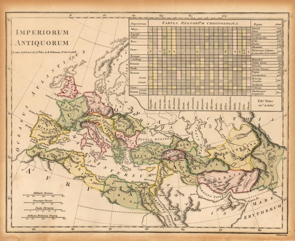
Imperiorum Antiquorum.
1800 (dated) 8.75 x 11 in (22.225 x 27.94 cm) 1 : 30000000
1800 (dated) 8.75 x 11 in (22.225 x 27.94 cm) 1 : 30000000
Description
This is Robert Wilkinson's 1800 historical map of Europe, North Africa, and the Near East, illustrating the ancient empires: in particular, the Roman Empire. It includes an ingenious table giving the chronology of various empires pertinent to the areas on the map, indicating which regions were occupied by whom, and when.
Publication History and Census
The map was produced for inclusion in Wilkinson's Atlas Classica Being a Collection of Maps of the Countries Mentioned By the Ancient Authors, Both Sacred And Profane. The first edition of this work was printed in 1797. While we have not encountered an example of this map so dated, it is likely that it appeared in that work as it did in every other edition. The atlas is well represented in institutional collections.Cartographer
Robert Wilkinson (fl. c. 1758 - 1825) was a London based map and atlas publisher active in the late 18th and early 19th centuries. Most of Wilkinson's maps were derived from the earlier work of John Bowles, one of the preeminent English map publishers of the 18th century. Wilkinson's acquired the Bowles map plate library following that cartographer's death in 1779. Wilkinson updated and retooled the Bowles plates over several years until, in 1794, he issued his first fully original atlas, The General Atlas of the World. This popular atlas was profitably reissued in numerous editions until about 1825 when Wilkinson died. In the course of his nearly 45 years in the map and print trade, Wilkinson issued also published numerous independently issued large format wall, case, and folding maps. Wilkinson's core cartographic corpus includes Bowen and Kitchin's Large English Atlas (1785), Speer's West Indies (1796), Atlas Classica (1797), and the General Atlas of the World (1794, 1802, and 1809), as well as independent issue maps of New Holland (1820), and North America ( 1823). Wilkinson's offices were based at no. 58 Cornhill, London form 1792 to 1816, following which he relocated to 125 Frenchurch Street, also in London, where he remained until 1823. Following his 1825 death, Wilkinson's business and map plates were acquired by William Darton, an innovative map publisher who reissued the General Atlas with his own imprint well into the 19th century. More by this mapmaker...
Source
Wilkinson, R., Atlas Classica being a Collection of Maps of the Countries, mentioned by the Ancient Authors, (London) 1806.
Condition
Fair. Toned and brittle margins from mat burn. Else very good with original wash and outline color.
References
OCLC 22150471. Rumsey 1203.043 (1823 edition).