This item has been sold, but you can get on the Waitlist to be notified if another example becomes available, or purchase a digital scan.
1700 Cluver Map of India, Chia, and Southeast Asia (Siam, Malay)
IndeOrientale-cluver-1700$125.00

Title
Inde Orientale.
1700 (undated) 8 x 10.5 in (20.32 x 26.67 cm)
1700 (undated) 8 x 10.5 in (20.32 x 26.67 cm)
Description
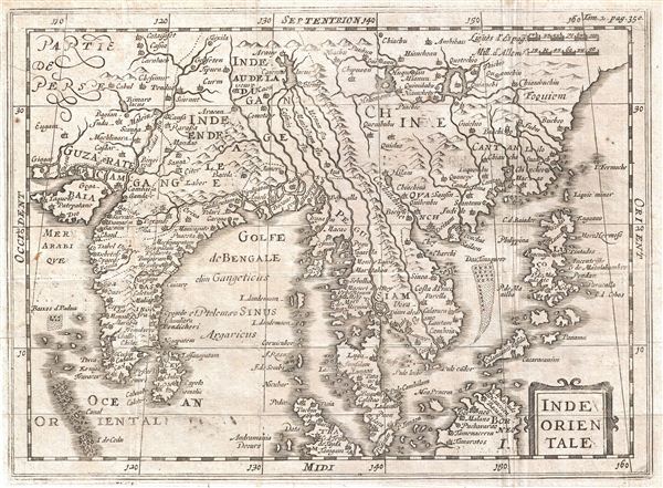
An uncommon c. 1700 map of India and Southeast Asia most likely drawn by Phillip Cluver. Centered on Siam (Thailand), Cluver's map covers from western India and the Indus Valley eastward as far as China, the Philippines, and Borneo, inclusive of India, Ceylon, the Gulf of Bengal, Southeast Asia, the Malay Peninsula, China, the Philippines, and parts of Borneo. The mapping of the region is noticeably primitive, especially as regards the overall form of India and the orientations of the inland river systems.
Cluver maps the apocryphal Lake of Chiamay, which he identifies is Cawmai, roughly in what is today Assam, India. early cartographers postulated that such a lake must exist to source the four important Southeast Asian river systems: the Irrawaddy, the Dharla, the Chao Phraya, and the Brahmaputra. This lake began to appear in maps of Asia as early as the 16th century and persisted well into the mid-18th century. Its origins are unknown but may originate in a lost 16th century geography prepared by the Portuguese scholar Jao de Barros. It was also heavily discussed in the journals of Sven Hedin, who believed it to be associated with Indian legend that a sacred lake linked several of the holy subcontinent river systems. There are even records that the King of Siam led an invasionary force to take control of the lake in the 16th century. Nonetheless, the theory of Lake Chiamay was ultimately disproved and it disappeared from maps entirely by the 1760s.
This map was originally drawn by Cluver in the early 1600s and was reissued many times – often posthumously – well into the early 18th century. The current example was prepared for Martineau de Plessis' Nouvelle Geographie, published in 1700.
CartographerS
Philipp Clüver (also Klüwer, Cluwer, or Cluvier, Latinized as Philippus Cluverius and Philippi Cluverii) (1580 - December 31, 1622) was a German geographer and historian active in Leiden in the late 16th and early 17th centuries. Clüver was born in the Royal Prussian city of Danzig (Gdansk), then a province of the Kingdom of Poland. He study of law at the University of Leiden before turning his attention to history and geography. Cluver traveled, mostly by foot, extensively throughout Europe, spending time in Germany, England, Scotland, Holland and Italy. On returning to Leiden he was given a special appointment as geographer and put in charge of the university's library. Cluver is best known for his general study of the geography of antiquity. A popular Enlightenment era field of study, antiquarian geography attempted to resolve place names known from classical literature but, by the time of the Renaissance, geographically confused. Cluver based his research not only on classical literary sources, but — and this was his primary contribution to the genre — also his extensive and local inspections of sites. Today he is considered one of the founding fathers of historical geography. Cartographically Cluver's most prominent works include his edition of Ptolemy's Geographia (based on Mercator's edition of 1578) and for miniature atlases that were reprinted for most of the 17thand 18th centuries. Cluver was also known as Klüwer, Cluwer, or Cluvier, Latinized as Philippus Cluverius and Philippi Cluverii. He died in Leiden in 1622. More by this mapmaker...
Martineau Du Plessis (fl. c. 1700) was a French geographer and schoolmaster from Fontenay, possibly Fontenay-le-Comte. He is best known for his multivolume geography, Nouvelle Geographie issued in 1700. Little else is known of his life. Learn More...
Source
Martineau du Plessis, Nouvelle Geographie, ou Description Exacte de l'Univers (George Gallet, Directeur de l'Imprimerie des Huguetan), vol 2, 1700.
Condition
Very good. Original fold lines. Blank on Verso.
References
Bibliotheque Nationale de France: Réserve A 200 189