1753 Jonas Hanway Map of Independent Tartary
IndependentTartary-gibson-1753$650.00

Title
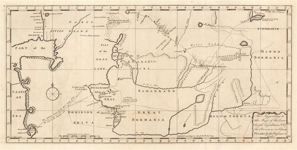
The Appendage to the Maps of the Orenburg Expedition, No. 1. and the Provinces in Siberia, No. 2. As taken by the Russians in 1747.
1753 (dated) 9.25 x 19.25 in (23.495 x 48.895 cm) 1 : 4056307
1753 (dated) 9.25 x 19.25 in (23.495 x 48.895 cm) 1 : 4056307
Description
This fascinating map of modern-day Turkmenistan, Uzbekistan and Tajikistan, engraved by John Gibson in 1753, was based on Russian maps Jonas Hanway included in his An Historical Account of the British Trade Over the Caspian Sea. Hanway supplemented the results of his own travels to the Caspian with a multiplicity of travelers' journals and the maps of other explorers, compiling an exhaustive collection of the most up to date geographical sources for this area, which remained one of the most obscure regions in the world. The map is centered on the Silk Route capitals of Samarkand and Bukhara, east of the Aral Sea. The cities of Tashkent and Badakshan are shown; the northeastern Caspian Sea and the lower part of the Ural River appears at the west; the eastern shore of the endoheiric Aral Sea is shown as well, but the western shore and indeed all the land between the Caspian and the Aral Sea is obscure. (The nomadic Tatars occupying that region were notoriously ill disposed towards travelers.) The map excels in detailing the regions south and east of the Aral, which include cities having 'plantations of trees' and 'mountains on which the Persians say is Gold and Silver and Lapis Lazuli.'
The Orenbergh Expedition
Ivan Kirillovich Kirilov (Иван Курилов, 1689 - 1737), the father of Russian Cartography, took part in Shestakov's expedition to Kamchatka between 1731 and 1733. The experience led him to appreciate the economic and strategic opportunities offered Russia in assessing her more remote provinces. In 1734, he proposed the creation of an administrative center to aid the assessment and exploitation of Russia's southeastern frontier regions. The ambitious project called for the construction of fortresses and even cities in order to extend Russia's influence and the reach of her geographers. To this end, the city of Orenburg was constructed in the southern Urals in 1735, the site having been chosen by Kirilov himself. Specifically, his intent was '...opening up transit routes to Bukhara, Badakhshan, Bulk, and to India'. Kirilov died in 1737, but the bureaucracy he established lived on under new administrators. After several false starts, Orenburg was re-founded in 1743, at the juncture of the Yaik and the Sakmara rivers, its present location. From that time on, Orenburg functioned as both a military and administrative center on the Kazakh frontier. Exploration in the Caspian region fell within Orenberg's sphere of influence. Even the work of English merchant explorers like Woodroofe and Elton would inform the geographical information compiled at Orenberg. This did not guarantee, however, that the material disseminated by the Expedition would be state-of-the-art: the maps based on the Orenberg Expedition that came to Jonas Hanway fell far short of his own maps of the Caspian and the Aral Sea published in the same work.Publication History and Census
The chart was engraved by John Gibson in 1753 for inclusion in Jonas Hanway's An Historical Account of the British Trade over the Caspian Sea. We are aware of three editions of the work; this example appeared in the third. We see eight examples of the complete work in institutional collections. We see only three examples of this map catalogued in OCLC, in the 1753 issue, at the Bibliotheque National de France, the National Library of Scotland, and the National Library of Israel.CartographerS
Jonas Hanway (August 12, 1712 - September 5, 1786), was an English philanthropist, traveller, and writer. He was apprenticed in 1729 to a merchant in Lisbon, but in 1743 he became partner to merchant and member of the British Russia Company Robert Dingley (1710 - 1780) who was based in St. Petersburg. This led to the travels in Russia, Central Asia, and Persia which would inform Hanway's (copious) writing on the topic of British trade in the Caspian Sea, which would earn him the attentions of scholar Charles Wilson who hailed him 'one of the most indefatigable and splendid bores of English history.' On his return to London his narrative brought him some fame and success, and thereafter he remained in the city devoted to good causes and good citizenship. He founded The Marine Society in 1756 (a charity supporting inland youths wishing to go to sea.) He was instrumental in the aid of various hospitals; arranged improvements in Londons's birth registration system; and in 1762 he was appointed a commissioner for victualling the navy. Hanway was an eccentric and a gadfly. He protested, voluminously, the English practice of tea drinking, both on the grounds of its effect on the health and on the balance of foreign trade. He was the first male Londoner to carry an umbrella. This shocking move drew the opprobrium of fellow Londoners who objected to the effeminate, French contraption, and the ire of hansom cab drivers who quite correctly identified the invention as a threat to their trade (rainstorms caused Londoners to flock to hansom cabs as a sheltered means of transport.) He died unmarried. A monument to his memory stands in Westminster Abbey, praising his works of charity. It discusses neither umbrellas nor tea. More by this mapmaker...
John Gibson (1724 – 1773) was an English map engraver active in London at the end of the 18th century. Gibson was the son of a locksmith. In 1739 he apprenticed to John Blundell as a stationer of Grub Street. Gibson proved a fine engraver and was much in demand by London map publishers. During his career he produced thousands of maps and was admired as a skilled engraver and sculptor. Among others, he engraved for Emanuel Bowen, Robert Sayer, Jean Palairet, John Rocque, Andrew Dury, and Benjamin Martin. His best known work was prepared in conjunction with Gentleman's Magazine. Gibson, sadly, was not as astute in his fiscal affairs as with the engravers pen and consequently spent much of his life consigned to debtor's prison. Learn More...
Source
Hanway, Jonas, An Historical Account of the British Trade over the Caspian Sea with the Author's Journal of Travels from England through Russia into Persia; and back through Russia, Germany and Holland, (London) 3rd Edition, 1762.
Condition
Very good. Original folds visible. Faint offsetting, small tallow spot, else excellent.
References
OCLC 764013906.