This item has been sold, but you can get on the Waitlist to be notified if another example becomes available, or purchase a digital scan.
1851 Tallis / Rapkin Map of Independent Tartary (Central Asia)
IndependentTartary-tallis-1851-2$87.50

Title
Independent Tartary.
1851 (undated) 10 x 13 in (25.4 x 33.02 cm) 1 : 10600000
1851 (undated) 10 x 13 in (25.4 x 33.02 cm) 1 : 10600000
Description
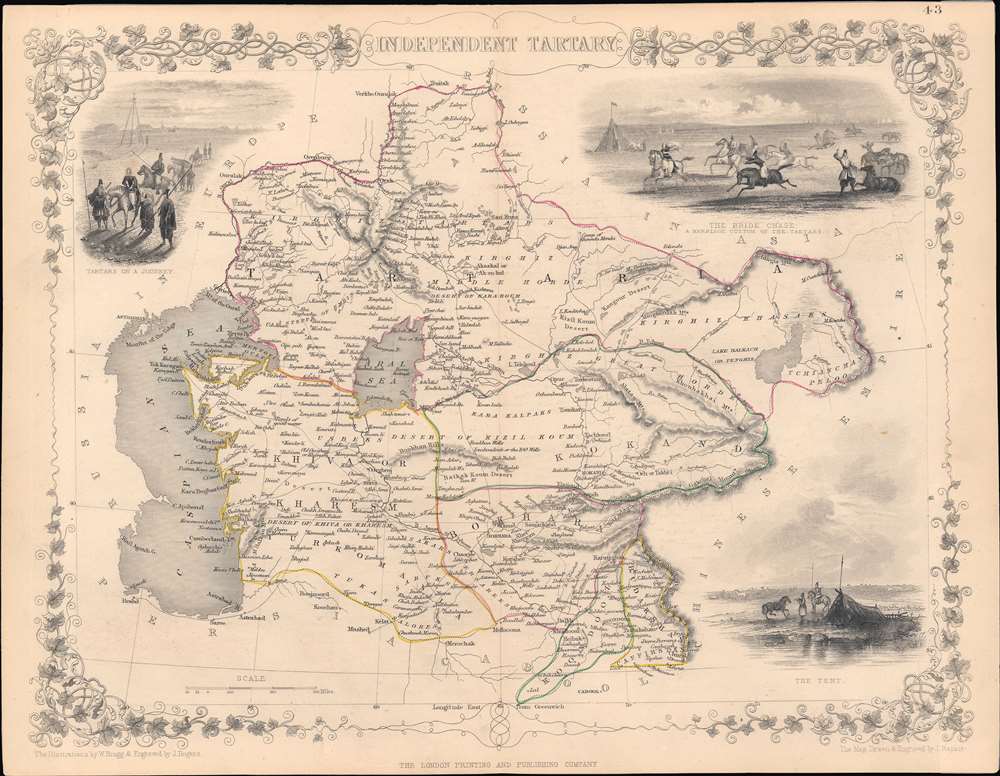
This is a highly decorative 1851 map of Central Asia drawn by John Rapkin and published by John Tallis, with hand-drawn colored borders between polities (the Emirate of Bukhara, the Khanate of Khiva, the Khanate of Kokand, and 'Tartaria,' roughly equivalent to today's Kazakhstan, Kunduz, and Badakhshan).
The Russians also encountered difficulties in trying to control the region, starting with a disastrous attack on Khiva in 1839. Rather than military strategy or technology, the main obstacle for the Russians was supplying troops so far from the Russian heartland in a region with minimal infrastructure. What could not be moved up rivers had to be carried over land, usually by caravans of horses, oxen, and camels, which required their own food and water. Thus, Russian progress into Central Asia was consistent but slow, and was aided by tensions between the independent states of the region. It was only in the final stage of the Russian conquest of Central Asia that railways reached the region, greatly aiding the control of Central Asia after conquest and facilitating the arrival of colonists.
Although there had been in-depth study of the region by Russian 'Orientalist' scholars by the time this map was produced, Western sources often had a hazy understanding of Central Asia and the peoples who lived there. This was in part a result of an attempt to inscribe taxonomic distinctions on a complex reality, replacing religious identities with ethnic identities in the process, and in part the repurposing of old terms for new purposes. Thus, the differences between, say, 'Tartaria,' 'Tartary,' and 'Turkestan' or between 'Tatars,' 'Turks,' 'Kazakhs,' 'Kirghiz,' and other groups were very uncertain.
A Closer Look
This map covers the regions between the Caspian Sea and Lake Balkhash and between Russia and Afghanistan. These include the ancient Silk Route kingdoms of Khiva, Kokand, and Bukhara. Today this region roughly includes Kazakhstan, Uzbekistan, Turkmenistan, Kyrgyzstan, and Tajikistan. This wonderful map offers a wealth of detail for anyone with an interest in the Central Asian portion of the ancient Silk Road. It identifies various caravan routes, deserts, wells, and stopping points, including the cities of Bokhara and Samarkand. Three vignettes by W. Bragg decorate the map, including an image of Tartars on a Journey, a horseback Bride Chase, and a Tartar campsite.The Great Game
Though part of a world atlas, this map was made for an English-speaking audience in the context of the 'Great Game,' a diplomatic confrontation between the British and Russian Empires over territories in Central and Southern Asia. The conflict, rooted in long-standing animosity between Russia and Britain, revolved around Afghanistan, which, while lacking significant resources of its own, was strategically situated. For its part, Russia feared Britain was making commercial and military inroads into Central Asia, an area long within the sphere of influence of St. Petersburg. Britain, conversely, feared Russia making gains in India, 'the jewel in the crown' of British Asia. The escalating tensions led to several wars and proxy wars in India and Afghanistan, were connected with the Russian annexations of Khiva, Bukhara, and Kokand, and tied to wider geopolitical tensions between Russia and Britain, evident in the Crimean War and elsewhere.Central Asia and the Russian Empire
Russian contacts with Central Asia predated this map by many centuries and Russian national identity is largely rooted in the relationship with the steppe and interaction (trade, warfare, etc.) with steppe-dwelling peoples, including the Mongols. However, using the latest military, communication, and transportation technology, the Russian Empire focused intently in the mid-19th century on subjugating Central Asia. Although the region had lost some of its wealth and luster from the height of the Silk Road, it was still home to powerful states that held their own in tussles with neighboring empires in the 18th and early 19th centuries.The Russians also encountered difficulties in trying to control the region, starting with a disastrous attack on Khiva in 1839. Rather than military strategy or technology, the main obstacle for the Russians was supplying troops so far from the Russian heartland in a region with minimal infrastructure. What could not be moved up rivers had to be carried over land, usually by caravans of horses, oxen, and camels, which required their own food and water. Thus, Russian progress into Central Asia was consistent but slow, and was aided by tensions between the independent states of the region. It was only in the final stage of the Russian conquest of Central Asia that railways reached the region, greatly aiding the control of Central Asia after conquest and facilitating the arrival of colonists.
Although there had been in-depth study of the region by Russian 'Orientalist' scholars by the time this map was produced, Western sources often had a hazy understanding of Central Asia and the peoples who lived there. This was in part a result of an attempt to inscribe taxonomic distinctions on a complex reality, replacing religious identities with ethnic identities in the process, and in part the repurposing of old terms for new purposes. Thus, the differences between, say, 'Tartaria,' 'Tartary,' and 'Turkestan' or between 'Tatars,' 'Turks,' 'Kazakhs,' 'Kirghiz,' and other groups were very uncertain.
Publication History
This map was part of the well-known Tallis's Illustrated Atlas and Modern History of the World published in 1851. It was drawn and engraved by John Rapkin and the vignette illustrations were drawn by W. Bragg and engraved by J. Rogers. This appears to be an atypical edition, as at bottom it says 'The London Printing and Publishing Company' rather than 'John Tallis and Company London and New York' as is generally the case in the published atlas.CartographerS
John Rapkin (July 18, 1813 - June 20, 1899) was an English mapmaker and engraver. Born in Southwark, Rapkin was the son of George Rapkin, a shoemaker, and his wife Elizabeth Harfy. Rapkin and his brother Richard both became engravers and his other brother, William Harfy Rapkin, became a copperplate printer. Rapkin produced works for James Wyld and John Tallis, including The United States and the relative position of Oregon and Texas for Wyld around 1845, and a series of eighty maps for Tallis that became 'Tallis's illustrated atlas, and modern history of the world' in 1851. Rapkin married Frances Wilmot Rudell on January 4, 1837, with whom he had at least eight children, some of whom became engravers, including his sons John Benjamin Rapkin (1837 - 1914), Alfred Thomas Rapkin (1841 - 1905), Joseph Clarke Rapkin (1846? - 1912), and Frederick William Rapkin (1859 - 1945). Rapkin operated under the imprint 'John Rapkin and Sons from 1867 until 1883, and was operating as 'John Rapkin and Sons' by 1887. Rapkin died in 1899 at the age of 85 soon after the death of his wife of over sixty years. More by this mapmaker...
John Tallis and Company (1838 - 1851) published views, maps, and atlases in London from roughly 1838 to 1851. Their principal works, expanding upon the earlier maps of John Cary and Aaron Arrowsmith, include an 1838 collection of London Street Views and the 1849 Illustrated Atlas of the World. The firm’s primary engraver was John Rapkin, whose name and decorative vignettes appear on most Tallis maps. Due to the embellishments typical of Rapkin's work, many regard Tallis maps as the last bastion of English decorative cartography in the 19th century. Although most Tallis maps were originally issued uncolored, it was not uncommon for 19th century libraries to commission colorists to "complete" the atlas. The London Printing and Publishing Company of London and New York bought the rights for many Tallis maps in 1850 and continued issuing his Illustrated Atlas of the World until the mid-1850s. Specific Tallis maps later appeared in innumerable mid to late-19th century publications as illustrations and appendices. Learn More...
John Tallis (November 7, 1817 - June 3, 1876) was an English map publisher and bookseller. Born in Stourbridge in Worcestershire, worked in his father's Birmingham agency from 1836 until 1842. Roughly in 1838, Tallis published a collection of London Street Views, and entered into a partnership with his brother Frederick Tallis from 1842 - 1849. Tallis and Company also published the Illustrated Atlas of the World in 1849. Also in 1849, Tallis traveled to New York City where he founded publishing agencies in six American cities. Upon returning from New York, Tallis paid his brother £10,000 for his share of the business, and operated from then on as John Tallis and Company until 1854. By 1853, John Tallis and Company had agencies in twenty-six cities in the United Kingdom, the United States, and Canada and employed over 500 people. By the end of 1853, Tallis had made the decision to share the burden of running such an extensive company and formed the London Printing and Publishing Company on February 24, 1854, becoming co-managing director with Ephraim Tipton Brain. After a series of setbacks, however, Tallis had to sell his estate and by 1861 was declared bankrupt. He was kept afloat by the kindness of friends and former employees, but none of his 'various ambitious projects' ever worked out for the rest of his life. Tallis married Jane Ball on December 6, 1836 in Birmingham, with whom he lived until her death in 1862. Tallis remarried on June 27, 1863 to Mary Stephens, with whom he had two children. Learn More...
Source
Tallis, J., The Illustrated Atlas, And Modern History Of The World Geographical, Political, Commercial and Statistical, (London and New York: Tallis) 1851.
Condition
Very good. Trace amounts of soiling near bottom center.
References
Rumsey 0466.045. Phillips (Atlases) 804.