This item has been sold, but you can get on the Waitlist to be notified if another example becomes available, or purchase a digital scan.
1780 Raynal / Bonne Map of India
IndeSuperieureInferieure-bonne-1780$100.00


Title
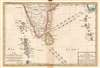
Carte de la Partie Superieure de l'Inde; Carte de la Partie Inferieure de l'Inde.
1780 (undated) 17.25 x 12.25 in (43.815 x 31.115 cm) 1 : 10000000
1780 (undated) 17.25 x 12.25 in (43.815 x 31.115 cm) 1 : 10000000
Description
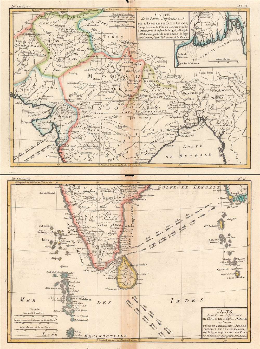
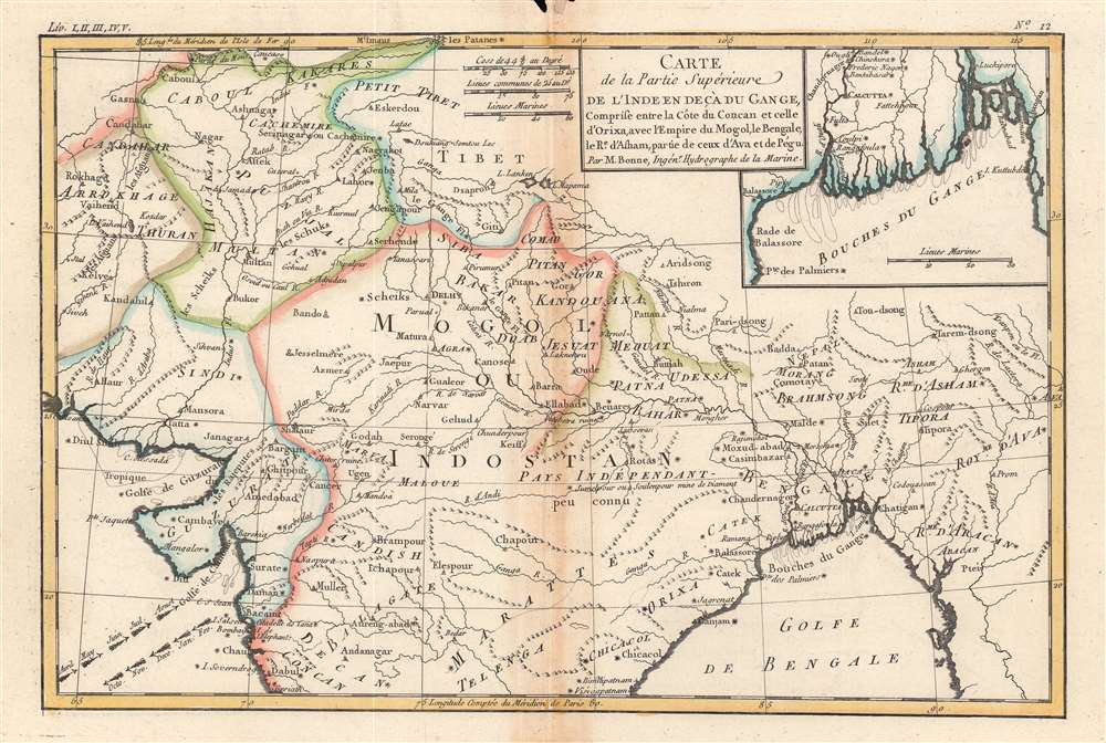
This is the 1780 Rigobert Bonne map of South Asia. In two sheets, it covers the entire subcontinent, from Afghanistan, Kashmir, and Tibet in the north to Ceylon, the Maldives, and the Nicobar Islands in the south.
At the time this map was made, India was undergoing important transitions that would eventually open the door to British dominance on the subcontinent, though that was not clearly apparent at the time. The once might Mughal Empire was beset by upstart competitors, namely the Marathas and Sikhs. The British were just one among several European empires with coastal outposts focused on trade rather than conquest. But in the decades following this map's publication, the British East India Company would displace the French as their main European competitors, gain control of Bengal and other territories, and begin taking on greater administrative roles.
A Closer Look
This map is highly detailed and beautifully crafted. Towns, religious sites, cities, and mountains are depicted in miniature representations. The direction of the all-important Indian Ocean trade winds and their corresponding seasons are depicted. An inset at top-right illustrates the Ganges Delta (or 'mouths of the Ganges') around Calcutta.At the time this map was made, India was undergoing important transitions that would eventually open the door to British dominance on the subcontinent, though that was not clearly apparent at the time. The once might Mughal Empire was beset by upstart competitors, namely the Marathas and Sikhs. The British were just one among several European empires with coastal outposts focused on trade rather than conquest. But in the decades following this map's publication, the British East India Company would displace the French as their main European competitors, gain control of Bengal and other territories, and begin taking on greater administrative roles.
Publication History and Census
This map was drawn by Bonne for Raynal's Atlas de Toutes les Parties Connues du Globe Terrestre, Dressé pour l'Histoire Philosophique et Politique des Établissemens et du Commerce des Européens dans les Deux Indes. Both the map itself and the entire atlas in this edition are held by numerous in North America and Europe.CartographerS
Rigobert Bonne (October 6, 1727 - September 2, 1794) was one of the most important French cartographers of the late 18th century. Bonne was born in Ardennes à Raucourt, France. He taught himself mathematics and by eighteen was a working engineer. During the War of the Austrian Succession (1740 - 1748) he served as a military engineer at Berg-op-Zoom. It the subsequent years Bonne became one of the most respected masters of mathematics, physics, and geography in Paris. In 1773, Bonne succeeded Jacques-Nicolas Bellin as Royal Cartographer to France in the office of the Hydrographer at the Depôt de la Marine. Working in his official capacity, Bonne compiled some of the most detailed and accurate maps of the period - most on an equal-area projection known erroneously as the 'Bonne Projection.' Bonne's work represents an important step in the evolution of the cartographic ideology away from the decorative work of the 17th and early 18th century towards a more scientific and practical aesthetic. While mostly focusing on coastal regions, the work of Bonne is highly regarded for its detail, historical importance, and overall aesthetic appeal. Bonne died of edema in 1794, but his son Charles-Marie Rigobert Bonne continued to publish his work well after his death. More by this mapmaker...
Guillaume Thomas Raynal (April 12, 1711 - March 6, 1796) was a French writer, philosopher, and historian active during the Enlightenment. Raynal was educated as a Jesuit, but left the order for unknown reasons, and moved to Paris where he dedicated himself to the production of a number of minor but popular historical works. Raynal's histories opened doors to elite social and artistic circles where he met and befriended various members of the Philosophe Coteries. Raynal's most important work is generally considered to be a 1770 collaboration with Diderot and others entitled, L'Histoire philosophique et politique des établissements et du commerce des Européens dans les deux Indes. Some of the philosophical ideas developed in the book drew negative attention from the authorities who banned the book and posted a notice for the arrest of its authors. Raynal fled to Berlin and later to St. Petersburg, where he lived for a number of years before returning to France in 1787. Though not a cartographer Raynal's name is often attached to several Atlases by Rigobert Bonne, from whom he composed the text. Learn More...
Source
Raynal, G., Atlas de Toutes les Parties Connues du Globe Terrestre, Dressé pour l'Histoire Philosophique et Politique des Établissemens et du Commerce des Européens dans les Deux Indes, (Paris) 1780.
Condition
Good. Some discoloration along original fold lines. Minor loss top center, both sheets.
References
Rumsey 3083.027, 3083.028, OCLC 977508035, 163641704.