This item has been sold, but you can get on the Waitlist to be notified if another example becomes available, or purchase a digital scan.
1844 Black Map of India and Singapore
India-black-1844$112.50

Title
India.
1844 (undated) 22.5 x 17 in (57.15 x 43.18 cm) 1 : 6100000
1844 (undated) 22.5 x 17 in (57.15 x 43.18 cm) 1 : 6100000
Description
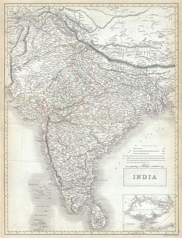
This is a fine example of the Adam and Charles Black's 1844 map of India. It covers the Indian subcontinent from the Indian Caucasus Mountains to the Indian Ocean and includes Ceylon or Sri Lanka and part of Kabul in Afghanistan. The map is coded with outline color according to territories under British Possession, territories under British influence by tribute protection and independent states. Various towns, cities, rivers, mountains, islands and several other topographical details are noted with relief shown by hachure.
This map's large inset of Singapore Island, in the lower right quadrant, is of particular interest. Like India, Singapore was administered by the British East India Company and, largely due to the opening of the Chinese market, was rapidly rising to dominate regional shipping. The map identifies the city of Singapore, the hospital, the European settlement, mercantile yards, the powder magazine, battery, and the sultan's mosque. This is one of the earliest maps to offer a specific detail of Singapore Island that we have encountered.
Most of India had, at this juncture, fallen under the control of the British East India Company. India, long an exporter of manufactured goods, instead became a supply house for raw materials to the British Empire. The Empire by this time had also started initiating the non-economic programs for education, culture, and social reform throughout the Subcontinent. Most historians consider this to be the true beginning of India's colonial period. The East India Company ruled India until 1858, after which it was governed by the British Raj until it finally gained independence in 1947. This map was engraved by Sidney Hall and issued as plate no. XXXIX in the 1844 edition of Black's General Atlas.
CartographerS
Charles and Adam Black (fl. 1807 - present) were map and book publishers based in Edinburgh. Charles and his uncle, Adam, both of Edinburgh, Scotland, founded their publishing firm in 1807. They published a series of maps and atlases throughout the 19th century. In addition to an array of atlases, the Black firm is known for their editions of the Encyclopedia Britannica (1817 - 1826) and the first publishing of Sir Walter Scott's novels in 1854. In 1889 the A. & C. Black publishing house moved to London where it remains in operation to this day. More by this mapmaker...
Sidney Hall (1788 - 1831) was an English engraver and map publisher active in London during the late 18th and early 19th centuries. His earliest imprints, dating to about 1814, suggest a partnership with Michael Thomson, another prominent English map engraver. Hall engraved for most of the prominent London map publishers of his day, including Aaron Arrowsmith, William Faden, William Harwood, and John Thomson, among others. Hall is credited as being one of the earliest adopters of steel plate engraving, a technique that allowed for finer detail and larger print runs due to the exceptional hardness of the medium. Upon his early death - he was only in his 40s - Hall's business was inherited by his wife, Selina Hall, who continued to publish under the imprint, "S. Hall", presumably for continuity. The business eventually passed to Sidney and Selina's nephew Edward Weller, who became extremely prominent in his own right. Learn More...
Source
Black, A. and C., Black's General Atlas (Edinburgh), 1844.
Black's General Atlas was a popular Scottish atlas of the world issued by the Edinburgh firm of Adam and Charles Black. This atlas was first issued in 1840 with subsequent editions being printed well into the 1890s. While most editions were printed in Edinburgh, an American edition was issued in 1857. Most early editions of his atlas were engraved by S. Hall. Typically this refers to Sidney Hall, who died in 1831, but in this case, since the engraving was initiated well after his death, it was most likely his widow, Selina Hall, who did the engraving. Later editions feature additional maps updated and engraved by William Hughes. Early editions featured outline color only, but later editions embraced a full color approach with pale green, yellow, and blue pastels. All editions are known for their meticulous presentation of the most up-to-date cartographic information. Moreover, this exceptionally long publication run provides a fine cartographic record of the middle to late 19th century - particularly as regards the complex cartographic evolution of the Americas through this period.
Condition
Very good. Original platemark visible. Blank on verso. Minor wear along original centerfold.
References
Philips (atlases) 4334.