This item has been sold, but you can get on the Waitlist to be notified if another example becomes available, or purchase a digital scan.
1851 Black Map of India and Singapore
India-black-1851$112.50

Title
India.
1851 (undated) 23 x 17 in (58.42 x 43.18 cm)
1851 (undated) 23 x 17 in (58.42 x 43.18 cm)
Description
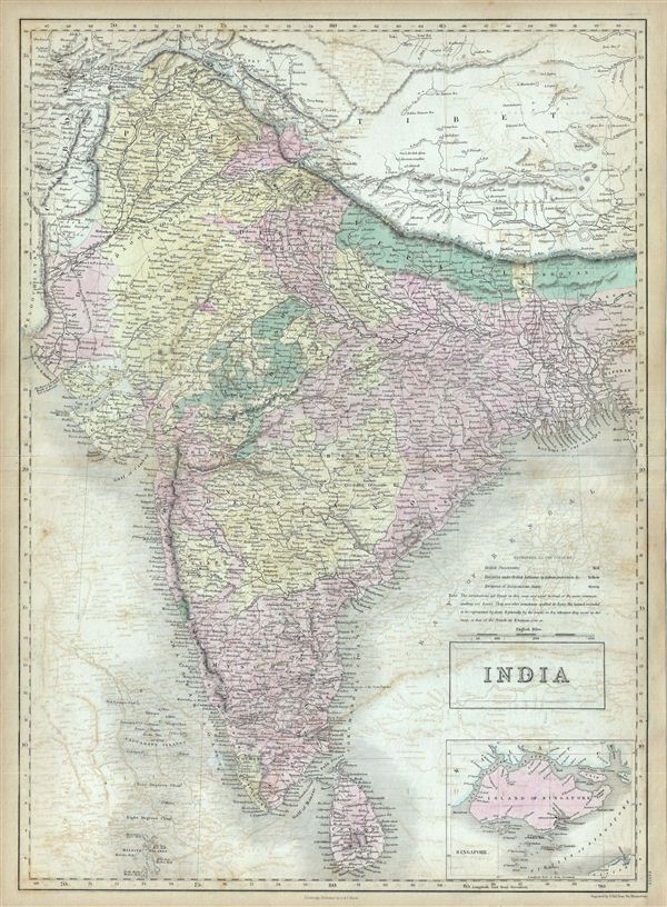
This is a fine example of the Adam and Charles Black's 1851 map of India. It covers the Indian subcontinent from the Indian Caucasus Mountains to the Indian Ocean and includes Ceylon or Sri Lanka and part of Kabul in Afghanistan. The map is color coded according to territories under British Possession, territories under British influence by tribute protection and independent states.
This map's large inset of Singapore Island, in the lower right quadrant, is of particular interest. Like India, Singapore was administered by the British east India Company and, largely due to the opening of the Chinese market, was rapidly rising to dominate regional shipping. The map identifies the city of Singapore, the hospital, the european settlement, mercantile yards, the powder magazine, battery, and the sultan's mosque. This is one of the earliest maps to offer a specific detail of Singapore Island that we have encountered.
At the same time, the Indian subcontinent was ruled by the British east India Company. The newly appointed Governor General, Lord Dalhousie brought along several progressive changes including education, railways, canals, telegraph etc. At the same time dissatisfaction with the east India Company was rapidly growing. In 1857, the sepoys of the British east Indian Company would revolt in India's First War of Independence. This ultimately led to the dissolution of the east India Company. Subsequently governance of India was administered directly by the British Crown. The British Raj ruled India until its independence in 1947.
Various towns, cities, rivers, mountains, islands and several other topographical details are noted with relief show in hachures. This map was engraved by Sidney Hall and issued as plate no. XXXIX in the 1851 edition of Black's General Atlas of the World.
CartographerS
Charles and Adam Black (fl. 1807 - present) were map and book publishers based in Edinburgh. Charles and his uncle, Adam, both of Edinburgh, Scotland, founded their publishing firm in 1807. They published a series of maps and atlases throughout the 19th century. In addition to an array of atlases, the Black firm is known for their editions of the Encyclopedia Britannica (1817 - 1826) and the first publishing of Sir Walter Scott's novels in 1854. In 1889 the A. & C. Black publishing house moved to London where it remains in operation to this day. More by this mapmaker...
Sidney Hall (1788 - 1831) was an English engraver and map publisher active in London during the late 18th and early 19th centuries. His earliest imprints, dating to about 1814, suggest a partnership with Michael Thomson, another prominent English map engraver. Hall engraved for most of the prominent London map publishers of his day, including Aaron Arrowsmith, William Faden, William Harwood, and John Thomson, among others. Hall is credited as being one of the earliest adopters of steel plate engraving, a technique that allowed for finer detail and larger print runs due to the exceptional hardness of the medium. Upon his early death - he was only in his 40s - Hall's business was inherited by his wife, Selina Hall, who continued to publish under the imprint, "S. Hall", presumably for continuity. The business eventually passed to Sidney and Selina's nephew Edward Weller, who became extremely prominent in his own right. Learn More...
Source
Black, A. and C., General Atlas Of The World, (Edinburgh) 1851.
Condition
Very good. Minor overall toning. Blank on verso. Offestting. Verso repair on original centerfold.
References
Rumsey 2305.045 (1854 edition). Philips (atlases) 4334.