This item has been sold, but you can get on the Waitlist to be notified if another example becomes available, or purchase a digital scan.
1548 Gastaldi Map of the Indian Peninsula
India-gastaldi-1548$300.00

Title
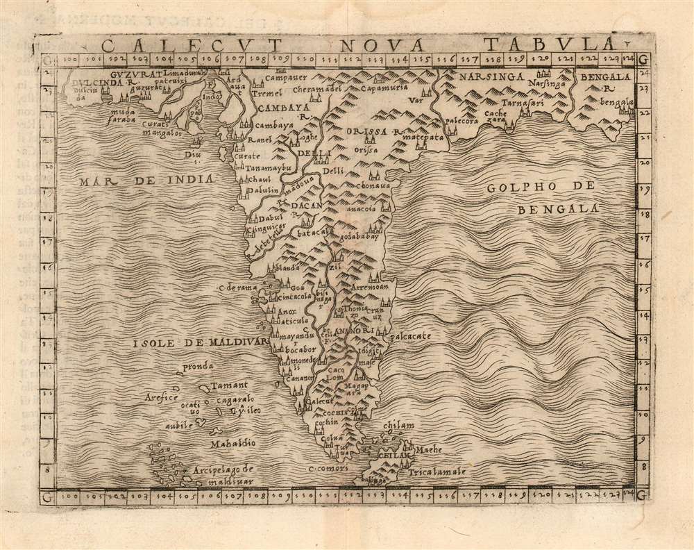
Calecut Nova Tabula.
1548 (undated) 5.15 x 6.75 in (13.081 x 17.145 cm) 1 : 16000000
1548 (undated) 5.15 x 6.75 in (13.081 x 17.145 cm) 1 : 16000000
Description
This is Giacomo Gastaldi's 1548 map of the Indian Peninsula. It is the earliest printed, modern map of India - all earlier maps of the region being iterations of Claudius Ptolemy's geographical information of the 2nd century. Though a Venetian, Gastaldi's information shows knowledge of the depth of Portuguese penetration of the subcontinent. Guzarat, Goa, Calecut, Delhi and many other place names appear on the map. Sri Lanka (Ceilam) is shown in its correct location and is not conflated with Sumatra, as many of the Ptolemaic maps appeared to do. The archaic term 'Taprobana' does not appear. The Maldives are shown with some exaggeration.
Publication History and Census
The map was printed in Venice for Gastaldi's La Geografia, his modernized Ptolemy, which was published in a sole 1548 edition. It appears separately in only the British Library, the Bayerische Staatsbibliothek, and the University of Toronto. The book is well represented in institutional collections.Cartographer
Giacomo Gastaldi (c. 1500 - October, 1566) was an Italian astronomer, cartographer, and engineer active in the second half of the 16th century. Gastaldi (sometimes referred to as Jacopo or Iacobo) began his career as an engineer, serving the Venetian Republic in that capacity until the fourth decade of the sixteenth century. During this time he traveled extensively, building a large library relating to voyages and exploration. From about 1544 he turned his attention to mapmaking, working extensively with Gextantiovanni Battista Ramusio, Nicolo Bascarini, and Giovanbattista Pedrezano, as well as taking private commissions for, among others, Venice's Council of Ten. He is credited with the fresco maps of Asia and Africa still extant in the map room of the Doge's Palace. Gastaldi was also one of the first cartographers to embrace copper plate over woodblock engraving, marking an important development in the history of cartography. His 1548 edition of Ptolemy's Geographia was the first to be printed in a vernacular; it was the first to be printed in copperplate. As with his Swiss/German contemporary Münster, Gastaldi's work contained many maps depicting newly discovered regions for the first time, including the first map to focus on the East Coast of North America, and the first modern map of the Indian Peninsula. His works provided the source for the vast majority of the Venetian and Roman map publishers of the 1560s and 70s, and would continue to provide an outsize influence on the early maps of Ortelius, De Jode, and Mercator. More by this mapmaker...
Source
Gastaldi, G., La Geografia, (Venice: Pedrezzano) 1548.
Giacomo Gastaldi's 1548 La Geografia was one of the most important early editions of Claudius Ptolemy's foundational geographical work. It was the first small-format, portable edition of a Ptolemy, and the first of the 16th century to be executed with copperplate maps. It was the most complete, modernized, edition of Ptolemy yet attempted, with 34 tabulae modernae included to correspond with the classic 26 Ptolemaic maps. Of the first Ptolemies, Gastaldi's 1548 work was the first to include separate regional maps of the Americas, most notably a map of the American east coast derived from the explorations of Verrazzano and Cartier. Perhaps most importantly, Gastaldi's Ptolemy was the first to be published in a vernacular language, Italian. This work is a testament to the humanist correspondence of the 16th century: many of the modern maps were derived from those of the German-Swiss geographer Sebastian Münster, who provided Gastaldi with commentary in the text of the new translation as well. Although Gastaldi's Ptolemy would only be published in one edition, it provided the basis for Girolamo Ruscelli's editions beginning in 1561.
Condition
Good condition. Faint waterstain to upper margin not affecting image.
References
Rumsey 11479.111. OCLC 500518634,