This item has been sold, but you can get on the Waitlist to be notified if another example becomes available, or purchase a digital scan.
1899 George Gill Chromolithograph Wall Map of India, Nepal, and Burma
India-gill-1899$1,250.00

Title
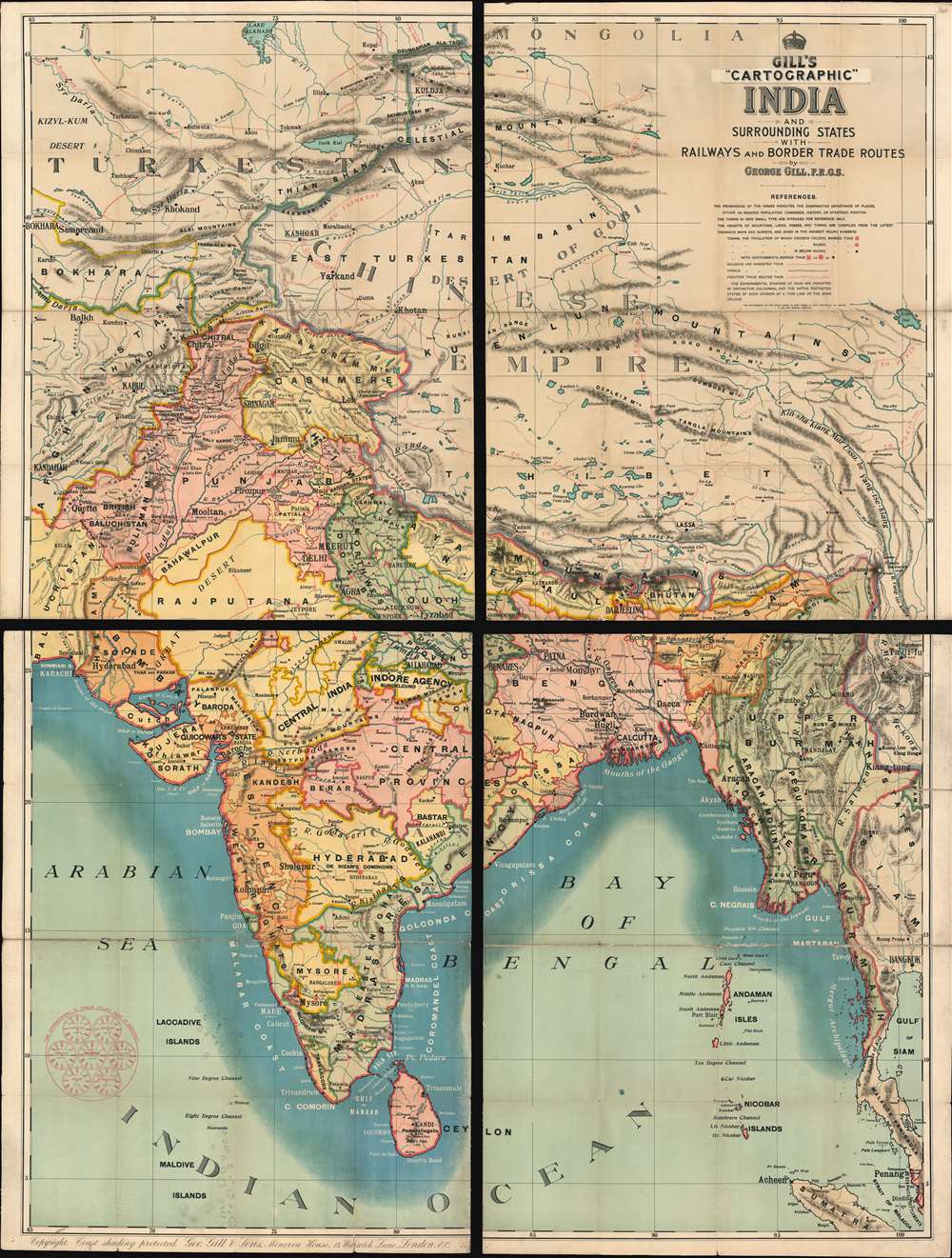
Gill's Cartographic India and Surrounding States with Railways and Border Trade Routes
1899 (undated) 81 x 61 in (205.74 x 154.94 cm)
1899 (undated) 81 x 61 in (205.74 x 154.94 cm)
Description
A rare and majestically enormous c.1900 four-part map of India by George Gill and Sons. Presented in chromolithographic color and consisting of four linen back folding sections, this massive map covers from Mongolia to Sri Lanka and from Karachi to Bangkok, with the central focus being the Indian Subcontinent. The subcontinent is divided into various British run or influenced agencies and sub-agencies, ranging from British Baluchistan to the Indore Agency. As a schoolroom map, the chart is not excessively dense, has bold color, and large easy to read print. The intense blue coastal shading is apparently something the at Gill was rightfully proud of, as a note int the lower left margin, states 'Copyright coast shading protected.
Chromolithography
Chromolithography is a color lithographic technique developed in the mid-19th century. The process involved using multiple lithographic stones, one for each color, to yield a rich composite effect. Oftentimes, the process would start with a black basecoat upon which subsequent colors were layered. Some chromolithographs used 30 or more separate lithographic stones to achieve the desired effect. Chromolithograph color could also be effectively blended for even more dramatic effects. The process became extremely popular in the late 19th and early 20th centuries, when it emerged as the dominate method of color printing.Publication History and Census
We have found very little evidence of this map private or institutional collections and no market history. We have found advertisements for Gill's 'Cartographic' series ranging from 1885 to 1901. We have tentatively dated this map to c. 1900 based upon the geographyCartographer
George Gill (April 1, 1836 - November 24, 1901) was a Liverpool and London based schoolmaster and educational publisher active in the late 19th and early 20th centuries. Gill began his career as an educated and schoolmaster who, recognizing a dearth of good educational materials, began publishing in Liverpool in 1864. He transferred the company to London in 1879, becoming a limited company under the imprint of George Gill and Sons. In time the firm was taken over by his sons, George Reginald Gill (1862 - and Claude Edward Gill (August 30, 1872 - August 16, 1960). The firm published books and maps for schoolrooms. Advertisements for their 'Cartographic' appear in educational periodicals from 1885 to about 1901. Under the Gill family the educational publishing firm prospered until closing its doors in 1941. The firm was based at Minerva House, no. 12 Warwick lane, London. More by this mapmaker...
Condition
Very good. Minor wear on original fold lines, especially at fold intersections. Four sections, as issued, mounted on original linen. Could be joined by a professional restorer.