This item has been sold, but you can get on the Waitlist to be notified if another example becomes available, or purchase a digital scan.
1733 Homann Heirs Map of India
India-homannheirs-1733$275.00

Title
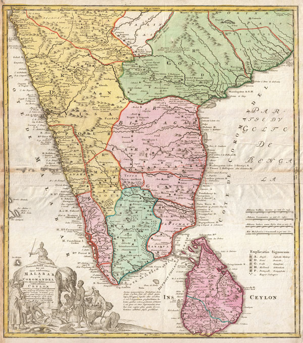
Peninsula Indiae citra Gangem, hoc est, Orae celeberrimae Malabar & Coromandel Cum adjacent Insula non minus celebratissima Ceylon Secundum prototypon Del' Islianum edita, insuperqs novissimis Observationibus correcta, et notates, quae cuivis genti Europaeae possidentur, terries et emporys, aucta, studio. Homannianorum Heredum Noriv. MDCCXXXIII Cum Privilegio S.C.M.
1733 (dated) 22 x 19 in (55.88 x 48.26 cm)
1733 (dated) 22 x 19 in (55.88 x 48.26 cm)
Description
A rare map of India and Ceylon issued in 1733 by the Homann Heirs. Covers the subcontinent roughly from Bombay south to Cape Comorin and includes all of Ceylon (Sri Lanka). Homan offers good detail along the coast naming numerous ports and, where appropriate, appending either an English, French, Danish, Dutch or Portuguese flag to indicate the European power laying claim to that port. The interior is more vague, though many of the major caravan routes are noted, if only speculatively. There are numerous annotations in Latin throughout. Homann also identifies various battle sites associated with the southward progress of the Mughal Empire in 1707. When Homann drew this map, only Madras, Malabar, Ceylon, and the European ports remained independent of Mughal control. A large title cartouche depicting Indian traders and an elephant appears in the lower left quadrant.
Cartographer
Homann Heirs (1730 - 1848) were a map publishing house based in Nuremberg, Germany, in the middle to late 18th century. After the great mapmaker Johann Baptist Homann's (1664 - 1724) death, management of the firm passed to his son Johann Christoph Homann (1703 - 1730). J. C. Homann, perhaps realizing that he would not long survive his father, stipulated in his will that the company would be inherited by his two head managers, Johann Georg Ebersberger (1695 - 1760) and Johann Michael Franz (1700 - 1761), and that it would publish only under the name 'Homann Heirs'. This designation, in various forms (Homannsche Heirs, Heritiers de Homann, Lat Homannianos Herod, Homannschen Erben, etc..) appears on maps from about 1731 onwards. The firm continued to publish maps in ever diminishing quantities until the death of its last owner, Christoph Franz Fembo (1781 - 1848). More by this mapmaker...
Source
Seutter, Matthaeus, Atlantis Geographicus Maior, [Grosser Atlas], Pts. 1 and 2, Nuremberg: Homann Erben, 1734-1781.
Condition
Good condition. Some creasing. Minor wear and discoloration along original centerfold and left margin. Else clean.
References
University of Washington Libraries, Rare Map Division, Atlas 912 At651.