This item has been sold, but you can get on the Waitlist to be notified if another example becomes available, or purchase a digital scan.
1898 'The Indian Engineer' Map of Rail and Canal Infrastructure, British Raj
India-indianengineer-1898$1,000.00


Title
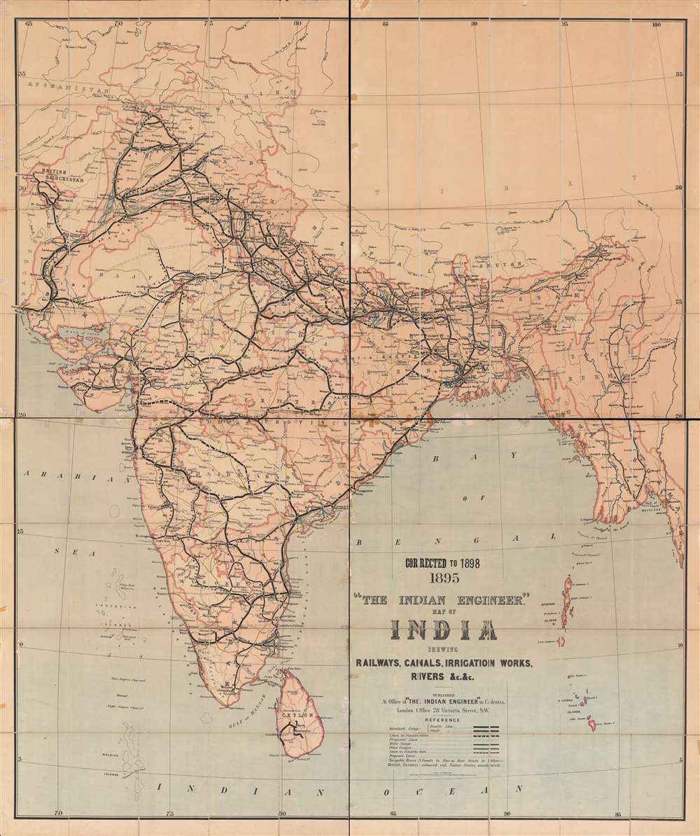
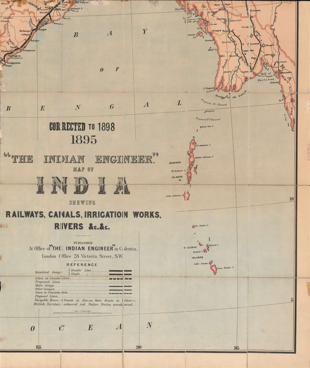
1895 Corrected to 1898 'The Indian engineer' map of India : shewing railways, canals, irrigation works, rivers, etc.
1898 (dated) 60 x 50.25 in (152.4 x 127.635 cm) 1 : 1900800
1898 (dated) 60 x 50.25 in (152.4 x 127.635 cm) 1 : 1900800
Description
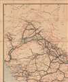
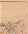
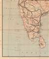
This is a unique and very large 1898 map of India, highlighting rail and irrigation infrastructure across the Raj. The map depicts India amid a railway and irrigation building boom that saw incredible feats of engineering and the tying together of distant corners of the Raj, but also enhanced colonial control and exploitation.
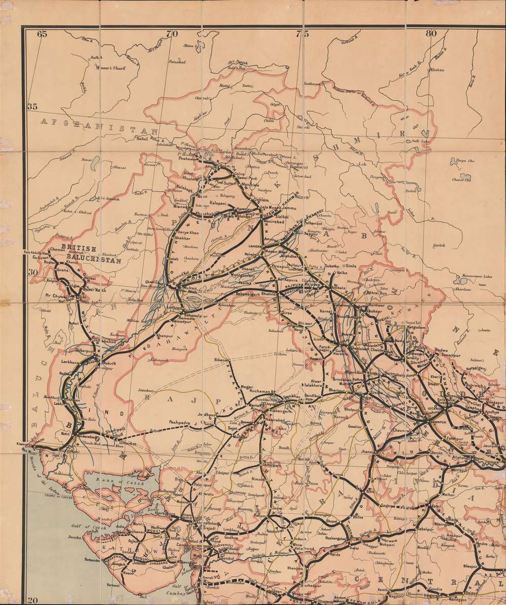
The gauge of rail lines is indicated, with narrow gauge, standard gauge, and other gauge lines all marked. Intriguingly, the British generally used an especially broad gauge of 5 feet 6 inches (1,676 mm) (here noted as 'standard gauge'), in South Asia, which they believed provided greater stability when faced with floods or strong winds. Smaller narrow gage lines were generally preferred for steep ascents.
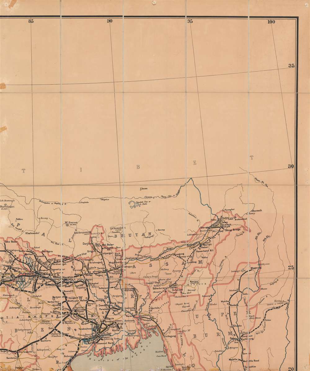
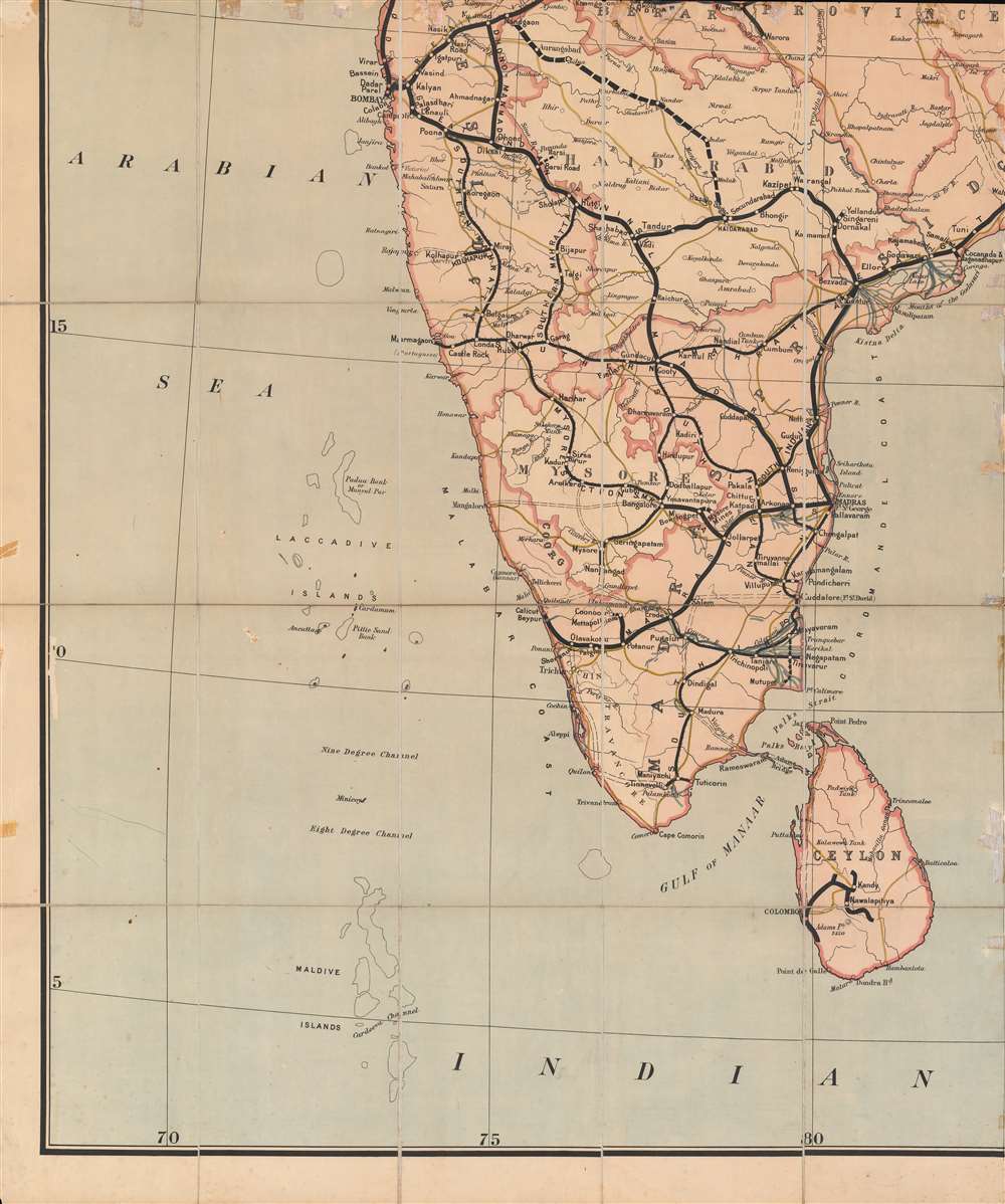
The rail network extended to the furthest reaches of the Raj, right up to the border with Afghanistan at Chaman, near Quetta, and Peshawar in the west, to the Himalayas in the north, and to Rangoon in the southeast. The sheer ambition of railway construction is astounding and includes a line connecting Chittagong to the Burmese rail network and a rail line across a string of limestone shoals known as Adams Bridge (Ram Setu) in the Palk Strait between the Indian mainland and Ceylon (partially completed in 1914 as the Pamban Bridge, an engineering marvel in its day).
After the Indian Mutiny in 1857 (to which, ironically, Dalhousie's centralizing agenda probably contributed), railways were seen as an essential tool for maintaining British control of the subcontinent, which also helps explain their density by century's end. At the same time, the easy travel between cities also aided the organizing efforts of independence activists. As incredible as the railways were as an engineering feat, they would not have been possible without the work of native laborers, who died by hundreds and thousands due to disease and accidents.
In the era of independence, despite the upheavals of partition and the severing of many lines, Indian Railways and the other successor companies continued to operate and improve passenger and freight rail. The rail network, which was nationalized in 1951, is still the primary means of intercity travel and carries millions of passengers daily.
Railways and the Raj
The map depicts the Indian railway network, including proposed lines and lines under construction, single versus double-tracked lines, major roads, navigable rivers, and canals. It also denotes the division of territory in the Raj, illustrating directly administered British India and the semi-autonomous Native or Princely States, of which there were hundreds, however only the largest appear here.The gauge of rail lines is indicated, with narrow gauge, standard gauge, and other gauge lines all marked. Intriguingly, the British generally used an especially broad gauge of 5 feet 6 inches (1,676 mm) (here noted as 'standard gauge'), in South Asia, which they believed provided greater stability when faced with floods or strong winds. Smaller narrow gage lines were generally preferred for steep ascents.
The rail network extended to the furthest reaches of the Raj, right up to the border with Afghanistan at Chaman, near Quetta, and Peshawar in the west, to the Himalayas in the north, and to Rangoon in the southeast. The sheer ambition of railway construction is astounding and includes a line connecting Chittagong to the Burmese rail network and a rail line across a string of limestone shoals known as Adams Bridge (Ram Setu) in the Palk Strait between the Indian mainland and Ceylon (partially completed in 1914 as the Pamban Bridge, an engineering marvel in its day).
Irrigation Projects
Less well-known than the railways is the wide-ranging irrigation works, particularly in the agricultural heartland of northern India. In the northeast especially, irrigation was used to produce cash crops, namely opium for export to China. Despite these public works, India suffered a series of horrific famines in the late 19th century. Soon after this map was published, a renewed push to irrigate land for food production was launched and irrigated land nearly doubled by independence in 1947.India's Railways, from Colonialism to Independence
India's railways were one of the most obvious impacts of British colonialism and remain one of the most tangible legacies of the British in India. The railway system became an important symbol of national identity and unity in the postcolonial era. Although initially driven by private interests, the government historically played an important management role. After all, it was Lord Dalhousie, Governor General of India, who determined that broad gauge should become the standard on the subcontinent (for him, railways were one of the 'three great engines of social improvement,' in India, along with the telegraph and a postal system). The Great Indian Peninsula Railway was built on an Act of Parliament and Dalhousie worked to centralize management of the railways, even if financing and construction was still primarily through private joint stock corporations.After the Indian Mutiny in 1857 (to which, ironically, Dalhousie's centralizing agenda probably contributed), railways were seen as an essential tool for maintaining British control of the subcontinent, which also helps explain their density by century's end. At the same time, the easy travel between cities also aided the organizing efforts of independence activists. As incredible as the railways were as an engineering feat, they would not have been possible without the work of native laborers, who died by hundreds and thousands due to disease and accidents.
In the era of independence, despite the upheavals of partition and the severing of many lines, Indian Railways and the other successor companies continued to operate and improve passenger and freight rail. The rail network, which was nationalized in 1951, is still the primary means of intercity travel and carries millions of passengers daily.
Publication History and Census
This map was prepared and published by The Indian Engineer, a specialized technical journal. This is the only known example of the 1898 edition. A 1901 edition is cataloged in OCLC (557742796) but is not noted as belonging to any institution. The original 1895 edition is also not known to exist in any institution or on the market.Cartographer
The Indian Engineer (c. 1858 – 1987) was a technical periodical published in Calcutta. It was originally titled The Engineer's Journal and Railway and Public Works Chronicle of India and the Colonies and was closely related to a monthly publication The Indian and Eastern Engineer. More by this mapmaker...
Condition
Average. Previous repairs evident, especially along fold lines. Foxing at bottom.